Duperre Islands
Bramble Haven is an atoll in the Louisiade Archipelago. Its islands on the northern section are grouped as the Duperre Islands.
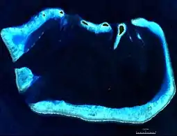 NASA-Satellite | |
 Bramble Haven | |
| Geography | |
|---|---|
| Location | Oceania |
| Coordinates | 11°14′00″S 152°00′00″E[1] |
| Archipelago | Louisiade Archipelago |
| Adjacent bodies of water | Solomon Sea |
| Total islands | 5, with 1 inhabited |
| Major islands |
|
| Area | 0.82 km2 (0.32 sq mi) |
| Length | 19.5 km (12.12 mi) |
| Width | 11 km (6.8 mi) |
| Administration | |
| Province | |
| District | Samarai-Murua District |
| LLG [2] | Louisiade Rural Local Level Government Area |
| Island Group | Duperre Islands |
| Largest settlement | Punawan (pop. 10) |
lagoon area | |
| Area covered | 110 km2 (42 sq mi; 13414.6%) |
total area | |
| Area covered | 175 km2 (68 sq mi; 21341.5%) |
| Demographics | |
| Population | 10 (2014) |
| Ethnic groups | Papauans, Austronesians, Melanesians. |
| Additional information | |
| Time zone |
|
| ISO code | PG-MBA |
| Official website | www |
Administration
it belongs to Milne Bay Province in the southeastern part of Papua New Guinea .
Geography
Bramble Haven is the eastern part of a large chain of atolls, reefs and islands that extends from the western side of the barrier reef of Vanatinai for a length of 400 km to the west, extending to the south coast of Papua peninsula.
Bramble Haven is located 5 km east of Long Reef and 9 km west of the Jomard Channel. Between Bramble Haven and Vanatinai are the small archipelago of Jomard Islands. Bramble Haven is a small, 17 km wide and 11 km long, atoll-like formation. The five most important reefs are concentrated around a rectangular lagoon. The reefs are wide and submerged. The reefs in the northern part of Bramble Haven have five small islands, which are also called Duperré Islands: Punawan (51 ha ), the small Duperre Island, Siva, and Panapwa Awanagamwana.
Bramble Haven stands since 2006 in the category "Mixed objects" that combines both criteria of the cultural and natural heritage, together with the Conflict Group, the Jomard Islands and Samarai and Lunn Island under the name: Milne Bay Seascape (Pacific Jewels of Marine Biodiversity) on the Tentative list of Papua New Guinea for the list in the world heritage of UNESCO . [3]
History
The atoll was named after a Schooner called Bramble Haven shipping in the area on August 5, 1846 have crashed on the reefs. Captain Charles B. Yule, the crew, and scientist Owen Stanley have all perished.[4]
The island is briefly described by Alan Villiers at several places in "The Coral Sea" [5]
Population
The population of the islands speak Misima-Paneati language. The language belongs to Western Oceanic languages group.[6] Only Punawan island is inhabited, although most of its villagers usually reside on Utian island through the year. The Utian islanders have many gardens for yams, coconuts, and brought cattle to ranch in the island.
References
- Prostar Sailing Directions 2004 New Guinea Enroute, p. 168
- LLG map
- Milne Bay Seascape (Pacific Jewels of Marine Biodiversity) UNESCO, World Heritage Centre
- Arthur Wichman: History of New Guinea (year 1828). Bd. 1, E. J. Brill, Leiden 1909, S. 72
- Villiers, Alan, The Coral Sea, Whittlesey House/McGraw-Hill, 1949
- M. Paul Lewis: Misima Paneati, A language of Papua New Guinea Ethnologue: Languages of the World. SIL International, Dallas 2009