Long Island (Papua New Guinea)
Long Island is a volcanic island in Papua New Guinea. It is located north of the island of New Guinea, separated from it by the Vitiaz Strait.
| Long Island | |
|---|---|
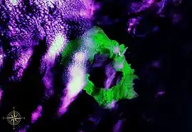 Long Island seen from space, with Lake Wisdom clearly visible (false color). | |
| Highest point | |
| Elevation | 1,280 m (4,200 ft) |
| Prominence | 1,280 m (4,200 ft) |
| Coordinates | 5°21′S 147°7′E |
| Geography | |
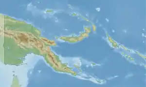 Long Island Location in Papua New Guinea | |
| Location | Papua New Guinea |
| Geology | |
| Mountain type | Complex volcano |
| Last eruption | November 1993 |
Geography
Two stratovolcanoes are located on the island: Mount Reaumur and Cerisy Peak. The summit of the volcanic complex collapsed during at least three major explosive eruptions, about 16,000, 4000, and 300 years ago. These produced a large caldera 10 x 12.5 km in size, now filled with a freshwater crater lake, Lake Wisdom. In 1953-1954 and 1968, volcanic activity created Motmot Island on the crater lake,[1] 200 x 200 m in size. The 1660 eruption was one of the largest in Papua New Guinea's recent history with an estimated air-fall volume in excess of 11 cu km,[2] comparable to the 1991 eruption of Mount Pinatubo, but the Global Volcanism Program gives a much higher estimate of 30 cu km. This cataclysmic event prompted legends of a "Time of Darkness".[3] The most recent (and a smaller) eruption occurred in 1993.
History
The first sighting by Europeans of Long Island was by the Spanish navigator Iñigo Órtiz de Retes on 12 August 1545 when on board of the carrack San Juan he tried to return from Tidore to New Spain.[4]
Long Island was charted in 1643 by Abel Tasman but he mistook it for part of the New Guinea mainland.
Long Island was utilised as a barge staging area by the Imperial Japanese during World War II. On December 26, 1943, D Company of the 592d Engineer Boat and Shore Regiment, 2d Engineer Special Brigade, US Army, landed on Long Island to prepare a radar station as part of the Battle of Cape Gloucester. The Royal Australian Air Force No. 338 Radar Station was set up at Matfum Point and became operational on April 6, 1944 and was to remain until March 1945.
References
- Specht, J.; et al. (1980). "Long Island, Papua New Guinea: Introduction" (PDF). Records of the Australian Museum. 34 (6): 407–417. doi:10.3853/j.0067-1975.34.1982.288. Retrieved 2016-04-08.
- Hoffman, G. (Fall 2008). "Volcanic flow deposits on the flanks of Long Island, Papua New Guinea: lavas or pyroclastics?". AGU Fall Meeting Abstracts. Harvard. 2008: V11C–2067. Bibcode:2008AGUFM.V11C2067H.
- Blong, Russell J. (1982). Time of Darkness. Canberra: Australian National University Press.
- Coello, Francisco "Conflicto hispano-alemán" Boletín de Sociedad Geográfica de Madrid, t.XIX. 2º semestre 1885, Madrid, p.371.
External links