Dzuluk
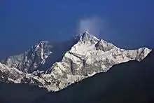
Dzuluk or Zuluk or Jhuluk or Jaluk is a small hamlet located at a height of 9,400 feet (2,900 m) on the rugged terrain of the lower Himalayas in East Sikkim of the Indian state Sikkim (Pincode 737131). This place is relatively an emerging and offbeat destination in East Sikkim. Today it is a tourist destination for the view of the eastern Himalayan mountain range including the Kanchenjunga.[1]
Dzuluk | |
|---|---|
Hamlet | |
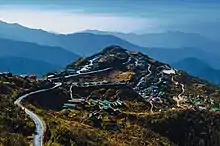
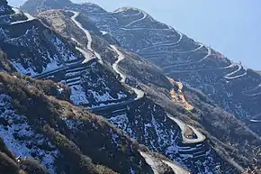 The switchback road at Dzuluk | |
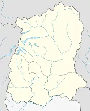 Dzuluk Location in Sikkim, India  Dzuluk Dzuluk (India) | |
| Coordinates: 27.2509908°N 88.7750191°E | |
| Country | |
| State | Sikkim |
| District | East Sikkim |
| Elevation | 2,900 m (9,400 ft) |
| Population | |
| • Total | 306 |
Historical importance
It was once a transit point to the historic Silk Route[2] from Tibet to India. The silk route that connected Lhasa[3] (Tibet) to Kalimpong was in use even a few decades ago until the Chinese invasion of Tibet. It was commonly used by traders traveling to Tibet through Jelep-la ("La" stands for mountain pass) as an overnight base. The route started from Kalimpong and passed through Pedong, Aritar, Dzuluk and Jelepla to Chumbi valley in Tibet.
Geography
Dzuluk is located at 27.2518°N 88.7775°E.
Climate
Dzuluk is at an altitude of about 9,400 feet. The summer temperature would be near 20 °C (68 °F) with substantial difference between the day and night temperature. The rainy season is a little protracted, and heavy to very heavy showers are common. The winter may see snowfall in the area of about 3–5 feet (0.91–1.52 m) of snow.
- October to February — winter, cold and snow.
- March to May — cold.
- June to September — the monsoon season.
Flora and fauna
Dzuluk is surrounded by wild forest, some of which are completely virgin. Sightings of deer, wild dogs, Himalayan bear, and the red panda are common. Some tigers have also reportedly been sighted in the area.

Several birds can also be seen such as Blood Pheasant, Himalayan monal, Kalij pheasant, Snow Pheasant and others. During the summer months, the area and its surrounding hills are covered with thousands of blooming rhododendron. Dzuluk during these months is colorful due to the variety of rhododendron.
Population
This small village accommodates a population of around 306 people and 65 households. Historically, Zuluk provides the accommodation facilities to the trader and porters of the silk route. The trader and porter are mostly from Tibet and Nepal at that instant. In Indo-China war, the pass has closed the trade between India and Tibet were stop, due to the agitation of Indo china War, the most of trader and porter retreat from silk route and some settle there after the war. The remaining settlers used to work in BRO (Border Road Organisation ), some in agriculture and the Indian army as a porter. There is an Indian Army base at Dzuluk, which has been used as a transit camp for the army movement to the Indo-Chinese border nearby. Farming is near-impossible due to soil quality and weather, and most of the land is fenced and military-controlled, making it unfit for grazing. BRO (Border Road Organisation ) , Tourism and porter in the Indian army are the only livelihoods of zuluk.
Transport
- Air
The Pakyong Airport,[4] (IATA airport code PYG) in Pakyong, Sikkim is the nearest airport. One can drive for around 3–4 hours from there to reach Dzuluk.
- Train
New Jalpaiguri railway Station (NJP) in West Bengal is the closest railway station. A drive of around 7–8 hours will take one to Dzuluk.
- Road
Dzuluk can be reached from Siliguri by various hired vehicle in roughly 7 hours. Tourists can also travel to Dzuluk from Gangtok in roughly 4 hours by hiring vehicles.
Nearby places
The three-level switchback roads of Dzuluk offer views of the Kangchenjunga and its mountain range. The other attractions of the place include lakes, temples, forests, and a route that leads to Tibet.
References
- Freshfield, D. W. (1903). Round Kangchenjunga: a narrative of mountain travel and exploration. London: Edward Arnold.
- Xinru Liu. The Silk Road In World History (PDF). Oxford University Press.
- Anne-Marie Blondeau and Yonten Gyatso, 'Lhasa, Legend and History,'in Françoise Pommaret-Imaeda (ed.)Lhasa in the seventeenth century: the capital of the Dalai Lamas, BRILL, 2003, pp.15–38, pp.21–22.
- "Archived copy". Archived from the original on 22 December 2015. Retrieved 5 November 2016.CS1 maint: archived copy as title (link)