Earlwood, New South Wales
Earlwood is a suburb in Inner West, in the state of New South Wales, Australia. Earlwood is located 10 kilometres south-west of the Sydney central business district, in the local government area of the City of Canterbury-Bankstown.
| Earlwood Sydney, New South Wales | |||||||||||||||
|---|---|---|---|---|---|---|---|---|---|---|---|---|---|---|---|
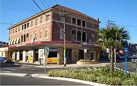 Earlwood Hotel, Homer Street | |||||||||||||||
| Population | 17,741 (2016 census)[1] | ||||||||||||||
| Established | 1829 | ||||||||||||||
| Postcode(s) | 2206 | ||||||||||||||
| Location | 10 km (6 mi) Inner West of Sydney CBD | ||||||||||||||
| LGA(s) | City of Canterbury-Bankstown | ||||||||||||||
| State electorate(s) | Canterbury | ||||||||||||||
| Federal Division(s) | Barton | ||||||||||||||
| |||||||||||||||
Earlwood stretches from the southern bank of the Cooks River to the northern bank of Wolli Creek. Marrickville is located to the east across Cooks River. Earlwood is primarily residential with some commercial developments around the main road, Homer Street.
History
Earlwood began as a land grant obtained by John Parkes in 1827. John Parkes and his sons operated logging camp called Parkes Camp in 1829 and felled the timber on his 50-acre grant. Later it became known as Parkestown.[2] The name was changed to Forest Hill around 1905-06 and changed again to Earlwood in 1918. 'Wood' reportedly commemorated a former mayor of Canterbury and 'Earl' was the name of two brothers who owned a pig and poultry farm on Wolli Creek. The Woodearl' estate was a subdivision in the area of Earlwood Primary School.
Early residents included F. and A. Martin who were granted land in the eastern part, and Joshua Thorpe, architect and Assistant Colonial Engineer, whose 80-acre (32 ha) estate was in the west, stretching from Cooks River to Wolli Creek. In 1828, Joshua Thorp built a house he called Juhan Munna, an Aboriginal phrase meaning "to go away." The house was later renamed Undecliffe and rented to managers of the Canterbury Sugarworks. The property was bought by the solicitor P.A.Tompson in 1850. In 1854, Tompson built a bridge on the site of Thorp's punt.
Frederick Wright Unwin, solicitor and director of the Australasian Sugar Company, obtained land in the Undercliffe area, east of Thorp's property, in 1840, and built his home, which he called Wanstead. Initially, a punt was used to cross the Cooks River. Later, a wooden bridge was built and the road eventually became known as Unwins Bridge Road. The name of the property survives in Wanstead Avenue and Wanstead Reserve. Abraham B. Pollack acquired eight grants in the 1830s, totalling 790 acres (320 ha), which covered most of Earlwood and Undercliffe. Subdivision began in the 1880s.
After World War I, a war services subdivision was created west of Wardell Road for retired soldiers and their families. The streets of that subdivision commemorate the names of famous men and battles connected with the war, such as Kitchener, Hamilton, Vimy, Fricourt, Polygon, Thompson, Guedecourt and Flers. The area incorporating Bedford, River, Grove, Richmond, and Stone streets was a subdivision known as the Canterbury estate and was divided for workers of the quarry at the end of River Street. This estate also took in Louisa, Sparke, Caroline, Elsie and Ann streets and also Willow lane, some of the streets had different names to those that they are known by today. A notable occupant of the area was the Scott family which operated the Scotties tissue factory on the corner of Louisa and River Streets.[3]
Between 1912 and 1957, electric trams operated along Homer Street to Earlwood, providing service to the city via Marrickville and Newtown.[4] The service is now provided by buses. Since the 1960s, the area has had an increasing population of Greek ancestry.
| 🌍 |
Heritage listings
Earlwood has a number of heritage-listed sites, including:
- Pine Street: Cooks River Sewage Aqueduct[5]
- Unwin Street: Wolli Creek Aqueduct[6]
- Earlwood Aboriginal Art Site[7]
Commercial area
The shopping centre is located on Homer Street, 500 metres up the hill from Bardwell Park railway station. A Coles supermarket and shops are also located in nearby Clarke Street. Earlwood has a number of restaurants and cafes scattered amongst the retail outlets, including Greek, Thai many other European establishments.
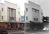
The site of the current KFC outlet was at one time the home of former prime minister John Howard whose parents operated two fuel outlets in neighbouring Dulwich Hill. At one time two cinemas were located on Homer Street, known as the Chelsea and the Mayfair. Some of the shopping centre buildings, churches and Chelsea Theatre were constructed by the builder William Ernest May formerly of 421 Homer Street.
The Earlwood Hotel is located on the corner of Earlwood Avenue and Homer Street. Earlwood - Bardwell Park RSL is located between Bardwell Park railway station and Wolli creek. The club also manages the EBP Sports Bowling Club in Doris Street. The Earlwood ex-servicemens club is located in Fricourt Avenue. Earlwood local library is located on the corner of William Street and Homer Street, with a heritage listed post box outside the library.
Transport
Earlwood is serviced by a number of bus routes by Transit Systems and Punchbowl Bus Company.
Earlwood was previously the end of the line for electric tram services running on a similar route to that of the current 423 bus service, an extension from the bottom of the hill at Undercliffe.
Churches
- Our Lady of Lourdes Catholic Church
- St Georges Anglican Church
- Earlwood Presbyterian Church
- Earlwood Uniting Church
- Earlwood Baptist Church
- The Salvation Army Earlwood
- The Transfiguration of Our Lord Greek Orthodox Church.
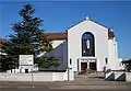 Our Lady of Lourdes Catholic Church
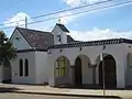 The Transfiguration of Our Lord Greek Orthodox Church
Parks and gardens
- Gough Whitlam Park and Waterworth reserve are on Bayview Avenue near Tempe station. Canterbury bicycle velodrome is located nearby. Clean up Australia day was originated here on the banks of Cooks river. The Cooks river Festival is an annual event held in Gough Whitlam park.
- Heynes Reserve is a passive recreation area at the junction of the Cooks River and Cup and Saucer Creek.
- Sutton Reserve is adjacent to Heynes Reserve. It features a playground and is connected to the northern bank of the Cooks River by a wooden footbridge.
- Hughes Park is a sporting and multi-use area located near the Canterbury border and runs along a concrete canal leading to the Cooks River.
- Simpson Reserve is further west along the Cooks River.
- Beaman Park and Wills Ground are located further east along the river near Wardell Road, and offer sporting fields, bike paths and BBQ facilities. Beaman Park is also home to Earlwood Wanderers soccer club and Earlwood Saints rugby league club and Wills Ground is home to the Canterbury Rugby Union Club. Stafford Walk, passing through the park alongside the river, was named after Ailsie Stafford, a long-time member of the Cooks River Valley Association. A plaque was installed on 6 May 1980.
- Earlwood Oval is a local park and sporting ground. It also has historical and social importance as a long-standing home to one of the lawn bowls clubs, cricket club, soccer and football fixtures and the location of one of very few "rocket" type playground fixtures. Earlwood Oval also serves as the primary home ground for the football (soccer) club, Earlwood Wanderers.
- Girrawheen Park is a large recreational area along the northern bank of Wolli Creek. It has views over Arncliffe, Turrella and Bardwell Park. This area is heritage listed and covers a large area of rare remnant bushland along the banks of Wolli creek and played a large part in the reasoning behind the construction of a road tunnel beneath the Bardwell valley.
- Wanstead Reserve, located between Wanstead Avenue and the Cooks River, was named after Wanstead, the property of Frederick Wright Unwin, established in 1840.[8]
- In the 1960s, Nanny Goat Hill (sometimes known as Prickly Pear Hill) was about to be quarried for use as fill in the construction of Sydney Airport runway extensions. Harold May, Peter Ridsdale and Carl Lyons formed a resistance committee to thwart the operation and succeeded in having Canterbury Council cancel the proposed destruction of this now valued recreation area. The Canterbury Mayor Jim Beaman was an advisor to the May, Ridsdale, Lyons committee. Beaman Park is named after him.
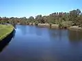 Cooks River, between Marrickville and Earlwood
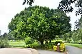 Tree at Gough Whitlam Park, Earlwood 2018
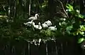 White ducks sunbathing at Gough Whitlam Park, Earlwood 2018
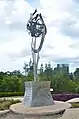 Statue of respect, unity & peace at Gought Whitlam Park 2018
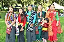 Women in traditional dress at Ubhauli Kirati festival 2017 at Gough Whitlam Park, Earlwood
Population
Demographics
Earlwood is a multicultural area, having a large proportion of Greek-Australians. Nearby Marrickville was a major centre of Sydney's Greek community in the 1950s and 1960s and many of its residents moved south into suburbs like Earlwood, which offered larger family homes and blocks of land. 18.0% of the population reported Greek ancestry at the 2016 Census.[1]
According to the 2016 census of Population, there were 17,741 residents in Earlwood. The most common reported ancestries were Greek 18.0%, Australian 12.5%, English 12.1%, Italian 7.2% and Lebanese 5.9%. 58.9% of people were born in Australia. The next most common countries of birth were Greece 7.6%, China 2.9%, Italy 2.6%, Portugal 2.3% and Lebanon 2.2%. 45.3% of people spoke only English at home. Other languages spoken at home included Greek 19.4%, Arabic 5.8%, Italian 4.2%, Portuguese 3.1% and Vietnamese 2.8%. The most common responses for religious affiliation were Catholic 30.1%, Orthodox 23.8% and No Religion 19.0%.[1]
Notable residents
The following notable people have lived in Earlwood:
- Former Prime Minister John Howard[9]
- Actor Grahame Bond (The Aunty Jack Show)
- Actor Alex Dimitriades
- Boxers Anthony Mundine and Tony Mundine
- Former Newtown and Australian Rugby league player Dick Poole
- Melbourne Storm player Josh Addo-Carr[10]
- Parramatta Eels player Blake Ferguson[11]
Politics
Federal Government: Earlwood is in the Division of Barton in the Australian House of Representatives. Historically, the Division of Watson has been a safe Labor electorate.
State Government: Earlwood is in the Electoral district of Canterbury in the New South Wales Legislative Assembly. The district includes surrounding suburbs of Canterbury, Campsie, Hurlstone Park, Croydon Park, western Dulwich Hill, eastern Belfield and northern Turrella.
Local Government: Earlwood is part of the Canterbury Ward of the City of Canterbury-Bankstown, which elects three councillors to the city council.
Topography
The suburb of Earlwood stretches in the northeast from the tall escarpment on the south bank of the Cooks River at its junction with Wolli Creek, a locality called Undercliffe. It stretches west (upriver) along the southern bank of the Cooks River up to the junction of Cup and Saucer Creek, by which point the river bank becomes much flatter. Wolli Creek forms the boundary of the suburb to the south. The Airport & South Line runs along the valley of Wolli Creek in this area, just outside the boundary of Earlwood, and provides the nearest rail access for residents of the suburb. In the west, the local artery road Bexley Road forms the boundary between Earlwood and neighbouring Clemton Park.
Region of Sydney
Although by most customary definitions Earlwood falls into the customary region of South Western Sydney or Canterbury-Bankstown, it sits at the far eastern end of that region and is viewed as culturally or demographically similar to Marrickville, from which it is separated by the Cooks River valley and parklands. Marrickville is part of the Inner West region, and so Earlwood is sometimes, especially in commercial contexts, identified as part of the Inner West region despite the geographical separation.[12] Because Earlwood is also within the cadastral Parish of St George (used for land title purposes), it also falls within the St George region by the traditional definition.
References
- Australian Bureau of Statistics (27 June 2017). "Earlwood (State Suburb)". 2016 Census QuickStats. Retrieved 14 March 2018.

- "Canterbury Rates Valuation Book-1879-84". Archived from the original on 1 September 2007. Retrieved 23 April 2007.
- The Book of Sydney Suburbs, Compiled by Frances Pollon, Angus & Robertson Publishers, 1990, Published in Australia ISBN 0-207-14495-8, page 90
- D. Keenan: Tramways of Sydney. Transit Press 1979
- "Cooks River Sewage Aqueduct". New South Wales State Heritage Register. Office of Environment and Heritage. H01322. Retrieved 18 May 2018.
- "Wolli Creek Aqueduct". New South Wales State Heritage Register. Office of Environment and Heritage. H01355. Retrieved 18 May 2018.
- "Earlwood Aboriginal Art Site". New South Wales State Heritage Register. Office of Environment and Heritage. H01801. Retrieved 21 January 2020.
- Dictionary of Sydney
- "Before office- John Howard".
- "In my shoes: Josh Addo-Carr". Melbourne Storm. 1 March 2017. Retrieved 13 January 2020.
- Walter, Brad (2 June 2013). "Family backs Ferguson to take the next step". The Sydney Morning Herald. Retrieved 25 January 2020.
- Australian Suburb Guide "Archived copy". Archived from the original on 26 December 2012. Retrieved 2013-01-16.CS1 maint: archived copy as title (link)
External links
- History of Earlwood (Canterbury City Council.)
- Greek Immigration to Australia
| Wikimedia Commons has media related to Earlwood, New South Wales. |