East Aceh Regency
East Aceh Regency (Indonesian: Kabupaten Aceh Timur) is a regency in eastern Aceh Special Region (Nanggroe Aceh Darussalam) of Indonesia. It is located on the island of Sumatra. The regency covers an area of 6,286.01 square kilometres and according to the 2010 census had a population of 360,475 people; the latest official estimate (as at 2014) is 379,507.[1]
East Aceh Regency
Kabupaten Aceh Timur | |
|---|---|
 Seal | |
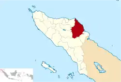 Location within Aceh | |
| Coordinates: 4°37′N 97°37′E | |
| Country | Indonesia |
| Region | Sumatra |
| Province | Aceh |
| Established | 1956 |
| Regency seat | Idi Rayeuk |
| Government | |
| • Regent | Hasballah Muhammad Thaib |
| • Vice Regent | Syahrul Syamaun |
| Area | |
| • Total | 6,286.01 km2 (2,427.04 sq mi) |
| Population (2014) | |
| • Total | 379,507 |
| • Density | 60/km2 (160/sq mi) |
| Time zone | UTC+7 (IWST) |
| Area code | (+62) 646 |
| Website | acehtimurkab |

The regency borders the Malacca Strait to the north-east, the city of Langsa and Aceh Tamiang Regency to the south-east, Gayo Lues Regency to the south, and Central Aceh Regency, Bener Meriah Regency and North Aceh Regency to the west.
Economy
This regency is rich in petroleum, more so than the North Aceh and Aceh Tamiang regencies. Fishing employs many people in the regency but little of it is exported; people depend on it for food.[2] The main fishing centre in the regency is in Idl. The regency also has several food-plant based industries producing tofu, tempeh and sun-dried banana chips.[2] Some areas are under plantation exploitation for palm oil and rubber, although there is only one state-owned company (TPN I) operating in the area. Plantations also produce cacao and chocolate and in the Lokop area iron ore and lead is mined.[2]
Administrative divisions
The regency is divided administratively into twenty-four districts (kecamatan), listed below with their areas and their populations at the 2010 Census.[3]
| Name | Area in km2[4] | Pop'n Census 2010[5] |
|---|---|---|
| Serba Jadi | 2,165.66 | 5,766 |
| Simpang Jernih | 544.63 | 3,397 |
| Peunaron | 79.74 | 8,206 |
| Birem Bayeun | 253.68 | 25,330 |
| Rantau Selamat | 159.80 | 11,223 |
| Sungai Raya | 159.00 | 10,672 |
| Peureulak | 318.02 | 39,691 |
| Peureulak Timur (East Peureulak) | 182.70 | 12,601 |
| Peureulak Barat (West Peureulak) | 92.30 | 13,633 |
| Ranto Peureulak | 129.00 | 21,945 |
| Idi Rayeuk | 79.60 | 33,136 |
| Peudawa | 75.90 | 10,274 |
| Banda Alam | 90.95 | 7,296 |
| Idi Tunong | 74.70 | 8,895 |
| Darul Ihsan | 54.50 | 5,447 |
| Idi Timur (East Idi) | 55.15 | 5,210 |
| Darul Aman | 131.50 | 17,043 |
| Nurussalam | 137.07 | 15,308 |
| Darul Falah | 42.40 | 2,902 |
| Julok | 234.36 | 23,884 |
| Indra Makmur | 89.05 | 15,772 |
| Pante Bidari (or Pante Beudari) | 233.25 | 21,490 |
| Simpang Ulim | 123.80 | 18,136 |
| Madat | 200.84 | 23,218 |
| Totals | 6,040.60 | 360,475 |
References
- Biro Pusat Statistik, Jakarta, 2011.
- "Aceh Timur" (PDF). Aceh Investment and Promotion Board. February 2010. Archived from the original (PDF) on July 7, 2011. Retrieved December 20, 2010.
- Biro Pusat Statistik, Jakarta, 2011.
- Badan Pusat Statistik, Jakarta, 2016.
- Biro Pusat Statistik, Jakarta, 2011.
Regencies and cities of Aceh | ||
|---|---|---|
Capital: Banda Aceh | ||
| Regencies |  | |
| Cities | ||
| Authority control |
|---|
