Subulussalam
Subulussalam is a city (Indonesian: kota) in Aceh province of Indonesia.[1] It is located on the island of Sumatra. Since 2 January 2007, the provincial government of Aceh declared Subussalam as a city as a result of the administration expansion from Aceh Singkil Regency.[2] It is located at 2°38′32″N 98°00′15″E.[1][3][4][5] It covers an area of 1,391 km2, and it had a population of 67,446 at the 2010 Census and of 75,044 at the 2015 Census; the latest official estimate (as mid 2019) is 79,991.[4][5][6]
Subulussalam | |
|---|---|
| Other transcription(s) | |
| • Jawoë | سبل السلام |
 Coat of arms | |
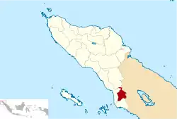 Location within Aceh | |
| Coordinates: 2°38′32″N 98°0′15″E | |
| Country | Indonesia |
| Region | Sumatra |
| Province | Aceh |
| City | 2 January 2007 |
| Government | |
| • Mayor | Merah Sakti Kombih |
| • Vice Mayor | Salmaza Kombih |
| Area | |
| • Total | 1,391 km2 (537 sq mi) |
| Population (mid 2019) | |
| • Total | 79,991 |
| • Density | 58/km2 (150/sq mi) |
| Time zone | UTC+7 (IWST) |
| Area code | (+62) 627 |
| Website | subulussalamkota.go.id |

Administrative divisions
The city is divided administratively into five districts (kecamatan):[2][3]
- Longkib
- Penanggalan
- Rundeng
- Simpang Kiri
- Sultan Daulat
Climate
Subulussalam has a tropical rainforest climate (Af) with heavy to very heavy rainfall year-round.
| Climate data for Subulussalam | |||||||||||||
|---|---|---|---|---|---|---|---|---|---|---|---|---|---|
| Month | Jan | Feb | Mar | Apr | May | Jun | Jul | Aug | Sep | Oct | Nov | Dec | Year |
| Average high °C (°F) | 30.9 (87.6) |
31.5 (88.7) |
31.8 (89.2) |
31.9 (89.4) |
32.0 (89.6) |
32.1 (89.8) |
31.7 (89.1) |
31.6 (88.9) |
31.0 (87.8) |
30.7 (87.3) |
30.3 (86.5) |
30.4 (86.7) |
31.3 (88.4) |
| Daily mean °C (°F) | 26.0 (78.8) |
26.3 (79.3) |
26.7 (80.1) |
26.9 (80.4) |
27.0 (80.6) |
26.8 (80.2) |
26.4 (79.5) |
26.4 (79.5) |
26.3 (79.3) |
26.3 (79.3) |
25.9 (78.6) |
25.9 (78.6) |
26.4 (79.5) |
| Average low °C (°F) | 21.2 (70.2) |
21.2 (70.2) |
21.6 (70.9) |
22.0 (71.6) |
22.1 (71.8) |
21.6 (70.9) |
21.2 (70.2) |
21.3 (70.3) |
21.6 (70.9) |
21.9 (71.4) |
21.6 (70.9) |
21.5 (70.7) |
21.6 (70.8) |
| Average rainfall mm (inches) | 246 (9.7) |
212 (8.3) |
274 (10.8) |
344 (13.5) |
250 (9.8) |
172 (6.8) |
179 (7.0) |
250 (9.8) |
250 (9.8) |
366 (14.4) |
365 (14.4) |
305 (12.0) |
3,213 (126.3) |
| Source: Climate-Data.org[7] | |||||||||||||
References
- "Subulussalam, Indonesia". geographic.org. Bethesda, MD, USA: National Geospatial-Intelligence Agency. 2008-02-29. Retrieved 2011-02-10.
- "Act No.8 2007". depdagri.go.id. Indonesian Ministry of Home Affairs. 2007-01-02. Retrieved 2011-02-10.
- "Peta Administrasi Subussalam" (PDF). know.arsipan.org. Rehabilitation and Reconstruction Agency (for Aceh and Nais). Retrieved 2011-02-10.
- "Profil Subulussalam". acehprov.go.id. Government of Aceh Province. 2010-05-05. Retrieved 2011-02-11.
- "KOTA SUBULUSSALAM" (PDF). acehprov.go.id. Government of Aceh Province. Retrieved 2011-02-11.
- Badan Pusat Statistik, Jakarta, 2019.
- "Climate: Subulussalam". Climate-Data.org. Retrieved 5 November 2020.
Regencies and cities of Aceh | ||
|---|---|---|
Capital: Banda Aceh | ||
| Regencies |  | |
| Cities | ||
| Authority control |
|---|
This article is issued from Wikipedia. The text is licensed under Creative Commons - Attribution - Sharealike. Additional terms may apply for the media files.
