Sabang, Aceh
Sabang is a city consisting of a main island (Weh Island) and several smaller islands off the northern tip of Sumatra. The islands form a city within Aceh Special Region, Indonesia. The administrative centre is located on Weh Island, 17 km north of Banda Aceh. The city covers an area of 153.0 square kilometres and according to the 2010 census had a population of 30,653 people;[2] the latest estimate (for July 2019) is 34,333.[3] Sabang is also known as the northernmost and westernmost city of Indonesia.
Sabang | |
|---|---|
| City of Sabang Kota Sabang | |
| Other transcription(s) | |
| • Jawoë | سابڠ |
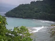
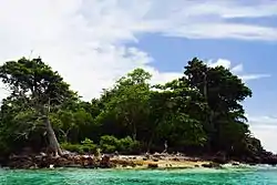 Rubiah Island, Sabang | |
 Coat of arms | |
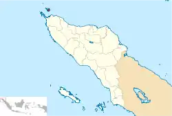 Location within Aceh | |
 Sabang  Sabang Sabang (Indonesia)  Sabang Sabang (Bay of Bengal) | |
| Coordinates: 5°53′39″N 95°19′9″E | |
| Country | |
| Province | |
| Government | |
| • Mayor | Nazaruddin |
| • Vice Mayor | Suradji |
| Area | |
| • Total | 153.00 km2 (59.07 sq mi) |
| Population (mid 2019 Estimate)[1] | |
| • Total | 34,333 |
| • Density | 220/km2 (580/sq mi) |
| Time zone | UTC+7 (Indonesia Western Time) |
| Area code | (+62) 652 |
| Website | sabangkota.go.id |
History
The Japanese occupied the island and installed numerous bunkers, fortifications and gun emplacements. Their remnants can still be seen, though most have been re-purposed or removed. On 6 May 1943, the Imperial Japanese Navy's submarine, the I-29, tasked with a Yanagi mission, landed the Indian leader and freedom fighter, Netaji Subhash Chandra Bose and his lieutenant, Abid Hasan at Sabang on Weh Island, instead of the Penang, to avoid detection by British spies.
Geography
Islands
Following islands in Indonesia are scattered around Sabang:
- Klah Island (0.186 km²)
- Rondo Island (0.650 km²)
- Rubiah Island (0.357 km²)
- Seulako Island (0.055 km²)
- Weh Island (121 km²)
Administrative districts
The city is divided into two districts (kecamatan), listed below with their areas and populations at the 2010 Census:
| Kecamatan | Area in sq.km |
Population at 2010 Census[4] |
No. of Villages |
|---|---|---|---|
| Sukajaya | 72.3 | 15,542 | 10 |
| Sukakarya | 52.5 | 15,111 | 8 |
Villages
Sabang has 18 villages in two districts (Sukajaya and Sukakarya). Sukajaya contained 10 villages, and Sukakarya contained 8 villages. Listed below with the name of all villages in Sabang with 2016 data:
| Villages | Kecamatan |
|---|---|
| Paya | Sukajaya |
| Keunekai | Sukajaya |
| Beurawan | Sukajaya |
| Jaboi | Sukajaya |
| Balohan | Sukajaya |
| Cot Abeuk | Sukajaya |
| Cot Ba'u | Sukajaya |
| Anoi Itam | Sukajaya |
| Ujong Kareung | Sukajaya |
| Ie Meule | Sukajaya |
| Iboih | Sukakarya |
| Batee Shok | Sukakarya |
| Paya Seunara | Sukakarya |
| Krueng Raya | Sukakarya |
| Aneuk Laot | Sukakarya |
| Kota Bawah Timur | Sukakarya |
| Kota Bawah Barat | Sukakarya |
| Kota Atas | Sukakarya |
Climate
Sabang has a tropical rainforest climate (Af) with moderate rainfall from February to August and heavy rainfall from September to January.
| Climate data for Sabang | |||||||||||||
|---|---|---|---|---|---|---|---|---|---|---|---|---|---|
| Month | Jan | Feb | Mar | Apr | May | Jun | Jul | Aug | Sep | Oct | Nov | Dec | Year |
| Average high °C (°F) | 27.4 (81.3) |
28.3 (82.9) |
30.8 (87.4) |
31.8 (89.2) |
29.4 (84.9) |
30.0 (86.0) |
29.7 (85.5) |
30.5 (86.9) |
29.7 (85.5) |
30.1 (86.2) |
28.5 (83.3) |
27.5 (81.5) |
29.5 (85.1) |
| Daily mean °C (°F) | 25.8 (78.4) |
26.2 (79.2) |
27.3 (81.1) |
28.2 (82.8) |
27.3 (81.1) |
27.9 (82.2) |
27.4 (81.3) |
28.2 (82.8) |
27.2 (81.0) |
27.8 (82.0) |
26.6 (79.9) |
26.1 (79.0) |
27.2 (80.9) |
| Average low °C (°F) | 24.2 (75.6) |
24.2 (75.6) |
23.8 (74.8) |
24.7 (76.5) |
25.3 (77.5) |
25.9 (78.6) |
25.2 (77.4) |
26.0 (78.8) |
24.8 (76.6) |
25.6 (78.1) |
24.8 (76.6) |
24.7 (76.5) |
24.9 (76.9) |
| Average rainfall mm (inches) | 183 (7.2) |
112 (4.4) |
100 (3.9) |
100 (3.9) |
154 (6.1) |
110 (4.3) |
114 (4.5) |
99 (3.9) |
174 (6.9) |
217 (8.5) |
241 (9.5) |
339 (13.3) |
1,943 (76.4) |
| Source: Climate-Data.org[5] | |||||||||||||
Transport
Airport
Sabang is served by the Maimun S aleh Airport. The airport is located southeast of the central city on Weh Island.
Sabang Port
India-Indonesia port development
Sabang has an ancient port on the historic Maritime Silk Route. To enhance cooperation in the national and maritime security and safety, trade connectivity, infrastructure and ecobomic development, the strategic partners India and Indonesia are jointly developing the Sabang deepsea port which also lies close to the India's southernmost territory of Andaman and Nicobar Islands. In 2002, Indian Navy and Indonesian Navy signed "Ind-Indo Corpat" agreement. In May 2018, "Shared Vision of Maritime Cooperation in the Indo Pacific" agreement was signed between these two nations when Indian Prime Minister Narendra Modi visited Indonesia. Consequently, both navies have been hosting bilateral "Samudra Shakti" naval exercise since November 2018 including in Java Sea and Andaman Sea. Indian naval ships have been regularly visiting Sabang port after the signing of the agreement. Several Indian navy ships undertook naval exercises and visits to Sabang e.g. a destroyer INS Rana in 2002, INS Sumitra in July 2018, INS VIJIT in 2019.[6]
Indonesia's minister for maritime affairs, Luhut Pandjaitan, stated that Indonesia has given economic and military access to India to strategic Sabang port which will invest in the port and economic zone of Sabang and build a hospital. He further stated that both India and Indonesia are large nations which do not need to lean towards any superpower, and that Indian navy ships will have access to the port which has 40 meter depth which is good for all vessels including submarines. Both nations started to discuss the Sabang port project in 2014. Shipping lanes passing through here are the global Choke point, Indonesia has “global maritime fulcrum” to counter balance the China's BRI, and this new India-Indonesia strategic partnership will balance the power in IOR and address the shared India-Indonesia's concerns about China's assertiveness in this region.[7] Port is a key element of India's Indo-Pacific strategy.[8]
International sail tourism event
The City hosted an international sail tourism event in September 2011. The sail race was participated in by around 50 ships with 15 crew members each. Besides sailing they visited interesting places packed in a 'tsunami' tourism, visit Gapang Beach and Iboih Beach with enchanting underwater scenery.[9]
Sail Sabang 2017 was held from Nov. 28 until Dec. 5 in Sabang. The event is the ninth installment of Sail Indonesia, an annual yacht rally that was first launched in 2009 on Bunaken Island, North Sulawesi.[10]
See also
- Indira Point, India's southernmost point close to Indonesia's Rondo Island
- Rondo Island, Indonesia's northernmost point close to India's Indira Point
- Sittwe Port, Myanmar's multimodal port being developed by India
- India's Look-East Connectivity projects
- Dawei Port Project
- Exclusive economic zone of Indonesia
- Exclusive economic zone of India
- Exclusive economic zone of Malaysia
- Exclusive economic zone of Thailand
- Extreme points of India
- Extreme points of Indonesia
- List of beaches in Indonesia
References
- Badan Pusat Statistik, Jakarta, 2019.
- Seta,William J. Atlas Lengkap Indonesia dan Dunia (untuk SD, SMP, SMU, dan Umum). Pustaka Widyatama. p. 7. ISBN 979-610-232-3.
- Badan Pusat Statistik, Jakarta, 2019.
- Biro Pusat Statistik, Jakarta, 2011.
- "Climate: Sabang". Climate-Data.org. Retrieved 29 October 2020.
- Eyeing Southeast Asia, India builds port in Indonesia, Economic Times, 20 May 2019.
- [https://www.hindustantimes.com/india-news/indonesia-gives-india-access-to-strategic-port-of-sabang/story-KPXWKy7PGAHFUi0jCL26yJ.html#:~:text=Indonesia%20gives%20India%20access%20to%20strategic%20port%20of,passes.%20india%20Updated%3A%20May%2017%2C%202018%2021%3A08%20IST Indonesia gives India access to strategic port of Sabang Sabang, also known as Weh island, is located 710 km southeast of the Andaman Islands and less than 500 km from the entrance of the Malacca Strait, through which almost 40% of India’s trade passes.], Hindustan Times, 17 May 2018.
- India builds Sabang Port in Indonesia, COnstruction World, 25 Mar 2019.
- RH, Priyambodo (28 May 2011). "Sabang to host sail tourism event in September". antaranews.com. Retrieved 13 December 2013.
- "Sail Sabang 2017 aims to put Aceh on global tourism map". The Jakarta Post. Retrieved 22 November 2017.
External links
| Wikivoyage has a travel guide for Sabang (Indonesia). |
- (in Indonesian) Official Sabang City
Regencies and cities of Aceh | ||
|---|---|---|
Capital: Banda Aceh | ||
| Regencies |  | |
| Cities | ||
| Authority control |
|---|