East Lampung Regency
East Lampung Regency is a regency (kabupaten) of Lampung Province, Sumatra, Indonesia. It has an area of 5,325.03 km² and a population of 951,639 people at the 2010 Census;[2] the latest official estimate (for mid 2020) is 1,051,994.[3] The regency seat is at the town of Sukadana.
East Lampung Regency
Kabupaten Lampung Timur | |
|---|---|
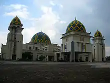
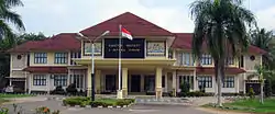 The regent's office in Sukadana | |
 Coat of arms | |
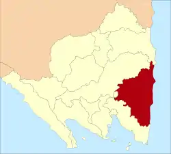 Location within Lampung | |
| Coordinates: 5.1027°S 105.6800°E | |
| Country | Indonesia |
| Province | Lampung |
| Regency seat | Sukadana |
| Government | |
| • Regent | Zaiful Bokhari |
| Area | |
| • Total | 5,325.03 km2 (2,056.01 sq mi) |
| Population (mid 2020)[1] | |
| • Total | 1,051,994 |
| • Density | 200/km2 (510/sq mi) |
| Time zone | UTC+7 (IWST) |
| Area code | (+62) 725 |
| Website | lampungtimurkab |

It contains the Way Kambas National Park and Satwa Elephant Eco Lodge.[4]
Administrative districts
East Lampung Regency is divided into twenty-four administrative districts (kecamatan), tabulated below with their areas and their populations at the 2010 Census,[6] together with the latest official estimates (for mid 2020).[7] The table also includes the number of administrative villages (rural desa and urban kelurahan) in each district and its post code.
| Name | Area in km2 | Pop'n Census 2010 | Pop'n Estimate mid 2020 | No. of vill. | Post code |
|---|---|---|---|---|---|
| Metro Kibang | 76.78 | 20,707 | 24,498 | 7 | 34331 -34335 |
| Batanghari | 148.88 | 54,601 | 62,821 | 17 | 34381 |
| Sekampung | 148.34 | 59,819 | 65,448 | 17 | 34382 |
| Margatiga | 250.73 | 43,395 | 46,885 | 13 | 34386 |
| Sekampung Udik | 339.12 | 68,093 | 75,317 | 15 | 34385 |
| Jabung | 267.85 | 46,550 | 53,057 | 15 | 34384 |
| Pasir Sakti | 193.94 | 34,410 | 38,525 | 8 | 34387 |
| Waway Karya | 211.07 | 34,454 | 31,767 | 11 | 34376 |
| Marga Sekapung | 177.32 | 26,035 | 26,737 | 8 | 34383 |
| Labuhan Maringgai (a) | 194.99 | 61,158 | 74,424 | 11 | 34198 |
| Mataram Baru | 79.56 | 26,672 | 29,320 | 7 | 34199 |
| Bandar Sribawono | 185.71 | 46,133 | 51,130 | 7 | 34389 |
| Melinting | 139.30 | 24,630 | 26,084 | 6 | 34377 |
| Gunung Pelindung | 78.52 | 21,052 | 21,606 | 5 | 34388 |
| Way Japara | 229.27 | 51,073 | 58,135 | 16 | 34396 |
| Braja Slebah | 247.61 | 21,733 | 24,032 | 7 | 34196 |
| Labuhan Retu | 485.51 | 41,386 | 46,712 | 11 | 34375 |
| Sukadana | 756.76 | 64,093 | 71,496 | 20 | 34194 |
| Bumi Agung | 73.17 | 16,931 | 18,369 | 7 | 34182 |
| Batanghari Nuban | 180.69 | 40,992 | 45,495 | 13 | 34372 |
| Pekalongan | 100.13 | 45,209 | 51,469 | 12 | 34391 |
| Raman Utara (North Raman) | 161.37 | 35,760 | 38,132 | 11 | 34371 |
| Purbolinggo | 222.03 | 40,152 | 45,406 | 12 | 34192 |
| Way Bungur (b) | 376.38 | 22,058 | 25,129 | 8 | 34373 |
| Totals | 5,325.03 | 951,639 | 1,051,994 | 264 |
Notes: (a) including 3 offshore islands - Pulau Gosongsekopong, Pulau Segama Besar and Pulau Segama Kecil.
(b) formerly Purbolinggo Utara (or North Purbolinggo).
References
- Badan Pusat Statistik, Jakarta, 2020.
- Biro Pusat Statistik, Jakarta, 2011.
- Badan Pusat Statistik, Jakarta, 2020.
- "Way Kambas Elephants Safari – Lampung". Indonesian Rainforest. Retrieved 22 February 2011.
- "Bird Flu Outbreak Kills Fowl". Jakarta Post. 29 January 2011. Retrieved 22 February 2011.
- Biro Pusat Statistik, Jakarta, 2011.
- Badan Pusat Statistik, Jakarta, 2020.
Regencies and cities of Lampung | ||
|---|---|---|
Capital: Bandar Lampung | ||
| Regencies | ||
| Cities | ||