Elkton, South Dakota
Elkton is a city in Brookings County, South Dakota, United States. The population was 736 at the 2010 census. Some of Elkton's population also have Minnesota addresses since the city is located so close to the state line.
Elkton, South Dakota | |
|---|---|
| Motto(s): "A Community Willing To Grow Together" | |
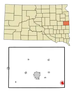 Location in Brookings County and the state of South Dakota | |
| Coordinates: 44°14′9″N 96°28′55″W | |
| Country | United States |
| State | South Dakota |
| County | Brookings |
| Incorporated | 1908[1] |
| Government | |
| • Mayor | Christina Weimer |
| Area | |
| • Total | 1.49 sq mi (3.87 km2) |
| • Land | 1.49 sq mi (3.87 km2) |
| • Water | 0.00 sq mi (0.00 km2) |
| Elevation | 1,752 ft (534 m) |
| Population | |
| • Total | 736 |
| • Estimate (2019)[4] | 726 |
| • Density | 485.94/sq mi (187.68/km2) |
| Time zone | UTC-6 (Central (CST)) |
| • Summer (DST) | UTC-5 (CDT) |
| ZIP code | 57026 |
| Area code(s) | 605 |
| FIPS code | 46-18700[5] |
| GNIS feature ID | 1254907[6] |
History
Elkton was platted in 1880.[7] It was named after the city of Elkton, Maryland.[8]
Geography
Elkton is located at 44°14′9″N 96°28′55″W (44.235716, -96.481887).[9]
According to the United States Census Bureau, the city has a total area of 1.55 square miles (4.01 km2), all land.[10]
Elkton has been assigned the ZIP code 57026 and the FIPS place code 18700.
Demographics
| Historical population | |||
|---|---|---|---|
| Census | Pop. | %± | |
| 1890 | 331 | — | |
| 1900 | 578 | 74.6% | |
| 1910 | 742 | 28.4% | |
| 1920 | 872 | 17.5% | |
| 1930 | 856 | −1.8% | |
| 1940 | 779 | −9.0% | |
| 1950 | 657 | −15.7% | |
| 1960 | 621 | −5.5% | |
| 1970 | 541 | −12.9% | |
| 1980 | 632 | 16.8% | |
| 1990 | 602 | −4.7% | |
| 2000 | 677 | 12.5% | |
| 2010 | 736 | 8.7% | |
| 2019 (est.) | 726 | [4] | −1.4% |
| U.S. Decennial Census[11] | |||
Since 2008 there have been 28 single family units added to the community.
2010 census
As of the census[3] of 2010, there were 736 people, 286 households, and 190 families residing in the city. The population density was 474.8 inhabitants per square mile (183.3/km2). There were 324 housing units at an average density of 209.0 per square mile (80.7/km2). The racial makeup of the city was 85.2% White, 0.4% African American, 12.1% from other races, and 2.3% from two or more races. Hispanic or Latino of any race were 14.5% of the population.
There were 286 households, of which 32.9% had children under the age of 18 living with them, 53.5% were married couples living together, 7.3% had a female householder with no husband present, 5.6% had a male householder with no wife present, and 33.6% were non-families. 28.7% of all households were made up of individuals, and 14% had someone living alone who was 65 years of age or older. The average household size was 2.53 and the average family size was 3.12.
The median age in the city was 31.9 years. 26.6% of residents were under the age of 18; 7.8% were between the ages of 18 and 24; 29.3% were from 25 to 44; 22.1% were from 45 to 64; and 14.1% were 65 years of age or older. The gender makeup of the city was 51.8% male and 48.2% female.
2000 census
As of the census[5] of 2000, there were 677 people, 267 households, and 185 families residing in the city. The population density was 436.2 people per square mile (168.6/km2). There were 289 housing units at an average density of 186.2 per square mile (72.0/km2). The racial makeup of the city was 98.82% White, 0.15% African American, 0.30% Native American, and 0.74% from two or more races. Hispanic or Latino of any race were 0.44% of the population.
There were 267 households, out of which 33.0% had children under the age of 18 living with them, 57.3% were married couples living together, 8.2% had a female householder with no husband present, and 30.7% were non-families. 27.7% of all households were made up of individuals, and 17.2% had someone living alone who was 65 years of age or older. The average household size was 2.51 and the average family size was 3.08.
In the city, the population was spread out, with 27.9% under the age of 18, 6.8% from 18 to 24, 24.1% from 25 to 44, 21.1% from 45 to 64, and 20.1% who were 65 years of age or older. The median age was 39 years. For every 100 females, there were 96.2 males. For every 100 females age 18 and over, there were 96.8 males.
The median income for a household in the city was $36,667, and the median income for a family was $47,969. Males had a median income of $30,313 versus $21,667 for females. The per capita income for the city was $18,912. About 5.9% of families and 6.8% of the population were below the poverty line, including 2.9% of those under age 18 and 18.7% of those age 65 or over.
Education
The Elkton Public School is the only school in Elkton. It is home to the grades of Kindergarten through 12th Grade and includes pre-school. The high school has won multiple state championships since it began and was the first to win three state championships in Boys Basketball. In 2010 the Girls Basketball team won the Class A State Tournament.[12]
See also
References
- "SD Towns" (PDF). South Dakota State Historical Society. Archived from the original (PDF) on 2010-02-10. Retrieved 2010-02-11.
- "2019 U.S. Gazetteer Files". United States Census Bureau. Retrieved July 30, 2020.
- "U.S. Census website". United States Census Bureau. Retrieved 2012-06-21.
- "Population and Housing Unit Estimates". United States Census Bureau. May 24, 2020. Retrieved May 27, 2020.
- "U.S. Census website". United States Census Bureau. Retrieved 2008-01-31.
- "US Board on Geographic Names". United States Geological Survey. 2007-10-25. Retrieved 2008-01-31.
- Chicago and North Western Railway Company (1908). A History of the Origin of the Place Names Connected with the Chicago & North Western and Chicago, St. Paul, Minneapolis & Omaha Railways. p. 68.
- Federal Writers' Project (1940). South Dakota place-names, v.1-3. University of South Dakota. p. 36. Archived from the original on 2016-08-09.
- "US Gazetteer files: 2010, 2000, and 1990". United States Census Bureau. 2011-02-12. Retrieved 2011-04-23.
- "US Gazetteer files 2010". United States Census Bureau. Archived from the original on 2012-01-25. Retrieved 2012-06-21.
- United States Census Bureau. "Census of Population and Housing". Retrieved June 12, 2016.
- "2010 Girls State Class "A" Basketball Tournament". South Dakota Public Broadcasting. Retrieved 3 May 2010.
External links
| Wikimedia Commons has media related to Elkton, South Dakota. |
Municipalities and communities of Brookings County, South Dakota, United States | ||
|---|---|---|
| Cities | 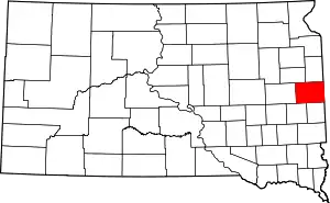 | |
| Towns | ||
| CDP | ||
| Other unincorporated communities | ||
| Townships |
| |
| Footnotes | ‡This populated place also has portions in an adjacent county or counties | |
| ||