Emlenton, Pennsylvania
Emlenton is a borough in Clarion and Venango counties in the U.S. state of Pennsylvania. The population was 625 at the 2010 census.[3] Of this, 617 were in Venango County, and only 8 were in Clarion County. The borough is home to the I-80 Emlenton Bridge, which spans the Allegheny River.
Emlenton, Pennsylvania | |
|---|---|
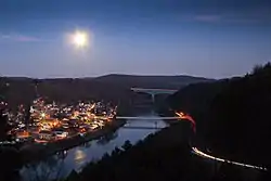 Emlenton with the 208 bridge and I-80 bridge in the background. The Allegheny River runs through this eco-corridor and past the small hamlet situated on the river. | |
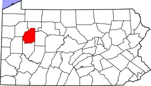
 Location of Emlenton in Clarion County, Pennsylvania. | |
 Map showing Clarion County in Pennsylvania | |
 Emlenton Location of Emlenton in Clarion County, Pennsylvania. | |
| Coordinates: 41°10′42″N 79°42′37″W | |
| Country | United States |
| State | Pennsylvania |
| Counties | Clarion and Venango |
| Settled | 1820 |
| Incorporated | 1859 |
| Government | |
| • Type | Borough Council |
| • Mayor | Jamie L. Hunt |
| Area | |
| • Total | 0.59 sq mi (1.52 km2) |
| • Land | 0.58 sq mi (1.51 km2) |
| • Water | 0.01 sq mi (0.01 km2) |
| Elevation | 920 ft (280 m) |
| Population (2010) | |
| • Total | 625 |
| • Estimate (2019)[2] | 573 |
| • Density | 984.54/sq mi (380.29/km2) |
| Time zone | UTC-5 (Eastern (EST)) |
| • Summer (DST) | UTC-4 (EDT) |
| ZIP code | 16373 |
| Area code(s) | 724 - Exchange: 867 |
| FIPS code | 42-23568 |
| Website | www |
History
Emlenton is named for Emlen, the wife of Joseph M. Fox, one of its founders.[4]
The Emlenton Historic District was added to the National Register of Historic Places in 1997.[5]
Geography
According to the United States Census Bureau, the borough has a total area of 0.59 square miles (1.52 km2), of which 0.004 square miles (0.01 km2), or 0.77%, is water.[3]
Demographics
| Historical population | |||
|---|---|---|---|
| Census | Pop. | %± | |
| 1870 | 488 | — | |
| 1880 | 1,140 | 133.6% | |
| 1890 | 1,126 | −1.2% | |
| 1900 | 1,190 | 5.7% | |
| 1910 | 1,110 | −6.7% | |
| 1920 | 1,025 | −7.7% | |
| 1930 | 1,137 | 10.9% | |
| 1940 | 986 | −13.3% | |
| 1950 | 945 | −4.2% | |
| 1960 | 844 | −10.7% | |
| 1970 | 854 | 1.2% | |
| 1980 | 807 | −5.5% | |
| 1990 | 834 | 3.3% | |
| 2000 | 784 | −6.0% | |
| 2010 | 625 | −20.3% | |
| 2019 (est.) | 573 | [2] | −8.3% |
| Sources:[6][7][8] | |||
As of the census[7] of 2000, there were 784 people, 322 households, and 200 families residing in the borough. The population density was 947.1 people per square mile (364.7/km2). There were 360 housing units at an average density of 434.9 per square mile (167.5/km2). The racial makeup of the borough was 98.85% White, 0.26% Native American, 0.38% Asian, and 0.51% from two or more races.
There were 322 households, out of which 29.2% had children under the age of 18 living with them, 45.3% were married couples living together, 12.7% had a female householder with no husband present, and 37.6% were non-families. 35.4% of all households were made up of individuals, and 17.7% had someone living alone who was 65 years of age or older. The average household size was 2.30 and the average family size was 2.94.
In the borough the population was spread out, with 23.5% under the age of 18, 7.0% from 18 to 24, 23.3% from 25 to 44, 22.7% from 45 to 64, and 23.5% who were 65 years of age or older. The median age was 42 years. For every 100 females there were 77.8 males. For every 100 females age 18 and over, there were 77.5 males.
The median income for a household in the borough was $30,227, and the median income for a family was $40,893. Males had a median income of $33,125 versus $21,875 for females. The per capita income for the borough was $16,952. About 10.7% of families and 15.1% of the population were below the poverty line, including 19.0% of those under age 18 and 11.4% of those age 65 or over.
.jpg.webp)
See also
![]() Media related to Emlenton, Pennsylvania at Wikimedia Commons
Media related to Emlenton, Pennsylvania at Wikimedia Commons
References
- "2019 U.S. Gazetteer Files". United States Census Bureau. Retrieved July 28, 2020.
- "Population and Housing Unit Estimates". United States Census Bureau. May 24, 2020. Retrieved May 27, 2020.
- "Geographic Identifiers: 2010 Census Summary File 1 (G001): Emlenton borough, Pennsylvania". U.S. Census Bureau, American Factfinder. Archived from the original on April 23, 2015. Retrieved April 23, 2015.
- Gannett, Henry (1905). The Origin of Certain Place Names in the United States. Govt. Print. Off. pp. 119.
- "National Register Information System". National Register of Historic Places. National Park Service. July 9, 2010.
- "Census of Population and Housing". U.S. Census Bureau. Retrieved 11 December 2013.
- "U.S. Census website". United States Census Bureau. Retrieved 2008-01-31.
- "Incorporated Places and Minor Civil Divisions Datasets: Subcounty Resident Population Estimates: April 1, 2010 to July 1, 2012". Population Estimates. U.S. Census Bureau. Archived from the original on 11 June 2013. Retrieved 11 December 2013.
External links
Municipalities and communities of Clarion County, Pennsylvania, United States | ||
|---|---|---|
| Boroughs | | |
| Townships | ||
| CDPs | ||
| Unincorporated communities | ||
| Footnotes | ‡This populated place also has portions in an adjacent county or counties | |
| ||
Municipalities and communities of Venango County, Pennsylvania, United States | ||
|---|---|---|
| Cities | 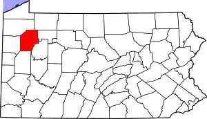 | |
| Boroughs | ||
| Townships | ||
| CDPs | ||
| Unincorporated communities | ||
| Ghost town | ||
| Footnotes | ‡This populated place also has portions in an adjacent county or counties | |
| ||
| Authority control |
|---|