Ena, Gifu
Ena (恵那市, Ena-shi) is a city located in Gifu, Japan. As of 1 June 2019, the city had an estimated population of 48,777, and a population density of 96.7 persons per km², in 19,820 households.[1] The total area of the city was 504.24 square kilometres (194.69 sq mi).
Ena
恵那市 | |
|---|---|
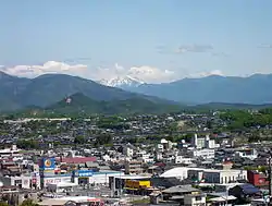 View of central Ena, Ena Valley Amusement Park and Mount Ontake | |
 Flag  Seal | |
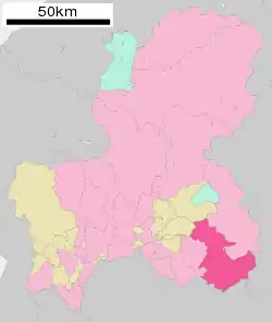
Location of Ena in Gifu Prefecture | |
 | |
 Ena | |
| Coordinates: 35°26′57.3″N 137°24′46.2″E | |
| Country | Japan |
| Region | Chūbu |
| Prefecture | Gifu |
| First official recorded | 539 AD |
| City Settled | April 1, 1954 |
| Government | |
| • Mayor | Yoshiaki Kachi |
| Area | |
| • Total | 504.24 km2 (194.69 sq mi) |
| Population (June 1, 2019) | |
| • Total | 48,777 |
| • Density | 97/km2 (250/sq mi) |
| Time zone | UTC+9 (Japan Standard Time) |
| City symbols | |
| - Tree | A. pycnanthum |
| - Flower | Lilium japonicum |
| Phone number | 0573-26-2111 |
| Address | 1-1-1 Shōge, Osashima-chō, Ena-shi, Gifu-ken 509-7292 |
| Website | Official website |
Geography
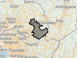
Ena is located in the Tōnō region of southeastern Gifu Prefecture.
- Mountains: Mount Kasagi, Mount Hoko, Mount Yūdachi, Mount Byōbu, Mount Yake, Mount Mitsumori
- Rivers: Kiso River, Agi River, Kamiyahagi River, Kamimura River, Akechi River, Toki River, Ori River
- Lakes: Ena Gorge, Lake Hokonoko, Lake Agigawa, Lake Okuyahagi, Lake Origawa
Climate
The city has a climate characterized by characterized by hot and humid summers, and mild winters (Köppen climate classification Cfa). The average annual temperature in Ena is 13.9 °C. The average annual rainfall is 1988 mm with September as the wettest month. The temperatures are highest on average in August, at around 26.4 °C, and lowest in January, at around 2.0 °C.[2]
Neighbouring municipalities
- Gifu Prefecture
- Shirakawa
- Nagano Prefecture
- Aichi Prefecture
Demographics
Per Japanese census data,[3] the population of Ena has remained steady over the past 40 years.
| Census Year | Population |
|---|---|
| 1970 | 57,876 |
| 1980 | 59,161 |
| 1990 | 58,044 |
| 2000 | 57,274 |
| 2010 | 53,973 |
History
The area around Ena was part of traditional Mino Province, and the name of "Ena" appears in Nara period records, including the Nihon Shoki. During the Edo period, it was mostly controlled by Iwamura Domain, and Ōi-juku developed as a post town on the Nakasendō highway connecting Edo with Kyoto. During the post-Meiji restoration cadastral reforms, the area was organised into Ena District, Gifu.
The city was founded on April 1, 1954 by the merger of two towns (Oi and Osashima) and six villages (Tōnō, Sango, Takenami, Kasagi, Nakano, and Iiji), all from Ena District. On October 25, 2004, Ena absorbed the towns of Akechi, Iwamura, Kamiyahagi and Yamaoka, and the village of Kushihara (all from Ena District) to create the expanded city of Ena.
Government
Ena has a mayor-council form of government with a directly elected mayor and a unicameral city legislature of 18 members.
Subdivisions
- Ōi-chō (大井町)
- Osashima-chō (長島町)
- Takenami-chō (武並町)
- Misato-chō (三郷町)
- Kasagi-chō (笠置町)
- Iiji-chō (飯地町)
- Nakanohō-chō (中野方町)
- Higashino (東野)
- Iwamura-chō (岩村町)
- Yamaoka-chō (山岡町)
- Akechi-chō (明智町)
- Kamiyahagi-chō (上矢作町)
- Kushihara (串原)
Economy
Ena was noted for its pulp and paper industry for many years. Production of precision instruments dominates the manufacturing sector.
Education
Ena has 14 public elementary schools and eight public middle schools operated by the city government, and three public high schools operated by the Gifu Prefectural Board of Education. The prefecture also operates one special education school. Chubu University maintains a subsidiary campus in Ena.
Transportation
Railway
Highway
 Chūō Expressway: Ena Interchange - Enakyō Service Area
 National Route 19
 National Route 257
 National Route 363
 National Route 418
Local attractions
- Nakasendō Ōi-juku
- Hiroshige Museum of Art, Ena
- Ena Gorge
- Agigawa Dam
- Iwamura Castle Ruins
- Nihon Taishō Mura
- Sasayuri no Yu
- Yahagi Dam
- Mongol Village
Notable people from Ena
- Kiyohiro Araki (member of the House of Councilors)
- Utako Shimoda (founder of Jissen Women's Educational Institute)
References
External links
![]() Media related to Ena, Gifu at Wikimedia Commons
Media related to Ena, Gifu at Wikimedia Commons
- Official website (in Japanese)
| Core city | ||
|---|---|---|
| Cities | ||
| Districts | ||
| Authority control |
|---|