Minokamo, Gifu
Minokamo (美濃加茂市, Minokamo-shi) is a city located in Gifu, Japan. As of 1 January 2019, the city had an estimated population of 56,972 and a population density of 74.81 persons per km2, in 22,508 households.[2] The total area of the city was 74.81 square kilometres (28.88 sq mi).
Minokamo
美濃加茂市 | |
|---|---|
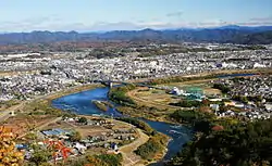 View of Downtown Minokamo, Kiso River and Mount Ontake, from Mount Hatobuki | |
 Flag  Seal | |
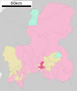 Location of Minokamo in Gifu Prefecture | |
 Minokamo | |
| Coordinates: 35°26′24.8″N 137°0′56.4″E | |
| Country | Japan |
| Region | Chūbu |
| Prefecture | Gifu |
| Government | |
| • Mayor | Seiichi Ito |
| Area | |
| • Total | 74.81 km2 (28.88 sq mi) |
| Population (January 1, 2019) | |
| • Total | 56,972 |
| • Density | 760/km2 (2,000/sq mi) |
| Time zone | UTC+9 (Japan Standard Time) |
| City symbols | |
| - Tree | Aphananthe aspera[1] |
| - Flower | Hydrangea[1] |
| Phone number | 0574-25-2111 |
| Address | 3431-1 Ōta-chō, Minokamo-shi, Gifu-ken 505-8606 |
| Website | Official website |

Geography
Minokamo is located in south-central Gifu Prefecture in the Nōbi Plain, between the Hida Mountains and the Kiso River.
Demographics
Per Japanese census data,[3] the population of Minokamo has increased rapidly over the past 40 years. Notably, the proportion of foreign nationals residing in the city is very high for Japan, at 9.2% as of October 2020.[4] The foreign residents are predominantly from Brazil or the Philippines, with small but growing Chinese and Vietnamese populations.[5]
| Census Year | Population |
|---|---|
| 1970 | 35,075 |
| 1980 | 39,531 |
| 1990 | 43,013 |
| 2000 | 50,063 |
| 2010 | 54,729 |
Climate
The city has a climate characterized by hot and humid summers, and mild winters (Köppen climate classification Cfa). The average annual temperature in Minokamo is 15.2 °C. The average annual rainfall is 1982 mm with September as the wettest month. The temperatures are highest on average in August, at around 27.9 °C, and lowest in January, at around 3.5 °C.[6]
| Climate data for Minokamo | |||||||||||||
|---|---|---|---|---|---|---|---|---|---|---|---|---|---|
| Month | Jan | Feb | Mar | Apr | May | Jun | Jul | Aug | Sep | Oct | Nov | Dec | Year |
| Record high °C (°F) | 16.6 (61.9) |
20.3 (68.5) |
24.7 (76.5) |
30.2 (86.4) |
33.6 (92.5) |
36.1 (97.0) |
37.9 (100.2) |
39.5 (103.1) |
38.4 (101.1) |
32.6 (90.7) |
25.1 (77.2) |
21.9 (71.4) |
39.5 (103.1) |
| Average high °C (°F) | 8.0 (46.4) |
9.2 (48.6) |
13.1 (55.6) |
19.5 (67.1) |
24.1 (75.4) |
27.3 (81.1) |
30.9 (87.6) |
32.7 (90.9) |
28.4 (83.1) |
22.5 (72.5) |
16.4 (61.5) |
10.8 (51.4) |
20.2 (68.4) |
| Average low °C (°F) | −1.8 (28.8) |
−1.4 (29.5) |
1.8 (35.2) |
7.4 (45.3) |
12.6 (54.7) |
17.8 (64.0) |
21.9 (71.4) |
22.9 (73.2) |
19.1 (66.4) |
12.0 (53.6) |
5.6 (42.1) |
0.3 (32.5) |
9.9 (49.7) |
| Record low °C (°F) | −8.7 (16.3) |
−8.6 (16.5) |
−8.9 (16.0) |
−2.0 (28.4) |
1.9 (35.4) |
8.3 (46.9) |
15.2 (59.4) |
15.3 (59.5) |
7.8 (46.0) |
0.9 (33.6) |
−2.5 (27.5) |
−6.9 (19.6) |
−8.9 (16.0) |
| Average precipitation mm (inches) | 57.8 (2.28) |
72.7 (2.86) |
137.1 (5.40) |
148.9 (5.86) |
187.2 (7.37) |
230.0 (9.06) |
270.3 (10.64) |
156.6 (6.17) |
231.3 (9.11) |
126.2 (4.97) |
92.9 (3.66) |
52.3 (2.06) |
1,763.3 (69.44) |
| Average precipitation days (≥ 1.0 mm) | 8.0 | 7.7 | 10.1 | 10.6 | 11.3 | 12.7 | 13.7 | 9.2 | 11.8 | 9.2 | 8.2 | 7.7 | 120.2 |
| Mean monthly sunshine hours | 142.9 | 157.3 | 187.7 | 192.8 | 184.1 | 143.0 | 158.0 | 198.9 | 156.0 | 157.5 | 142.3 | 145.8 | 1,966.3 |
| Source: Japan Meteorological Agency | |||||||||||||
History
The area around Minokamo was part of traditional Mino Province. In the Edo period, the area was divided between the holdings of Owari Domain and Naegi Domain, and tenryō holdings directly under the Tokugawa shogunate. Ōta-juku flourished as a post station on the Nakasendō highway connecting Edo with Kyoto. In the post-Meiji restoration cadastral reforms, Kamo District in Gifu prefecture was created. The modern city was formed on April 1, 1954 by the merger of the towns of Ota and Furui with the villages of Yamanoue, Hachiya, Kamono, Ibuka, Shimoyoneda and Miwa.[7]
Government
Minokamo has a mayor-council form of government with a directly elected mayor and a unicameral city legislature of 16 members.
Economy
The area around Minokamo was formerly known for sericulture. Agriculture, including horticulture remains an important component of the local economy, producing crops such as rice, Asian pears, and persimmons. However, since the 1960s, the area has become increasingly industrialized as part of the Chubu Plateau Industrial Zone. Industries include textiles, semiconductor, electronics, machine tools and automotive components, as well as food products.
Education
Tertiary Education
- Shogen Junior College, a traditional Japanese arts and Buddhist scripture university run by the Shogenji Temple.
- Ajisai Nursing College
- Takumi Academy, a Gifu prefecture-run vocational school that offers associates degrees in industrial technology, and construction, and vocational certificates in residential construction, automobile engineering, and public facilities.
Primary and Secondary Schools
Minokamo has nine public elementary schools, and two public junior high schools operated by the city government, a junior high school operated by an association between Minokamo City and the neighbouring Tomika Town, and a private combined junior/senior high school, Minokamo Gakuen. The city has two public high schools operated by the Gifu Prefectural Board of Education, which also operates a special education school.
Minokamo has a Brazilian school, the Colégio Isaac Newton Japão ("Isaac Newton College Japan"; )[8][9]
Transportation
Railway
Bus
Local attractions
- Shōgen-ji, a Buddhist monastery
- The Ota-juku area, a post town on the Nakasendo
- River Port Park Minokamo, a park with river sports activities
- Gifu-Seiryu Satoyama Park, a prefectural park with outdoor activities
- Yamazaki Mazak Machine Tools Museum[13]
- Koyama Kannon Temple
- Kobi no Tengusan, the main shrine of the Aranagikyō Religion
Seasonal Festivals
- Summer Onsai Festival (on the first weekend of August)
- Autumn Onsai Festival (in October)
- Minokamo Citizens' Festival (in November)
Notable people from Minokamo
- Tsubouchi Shōyō, author
References
- "Archived copy" 市の紹介. Minokamo official website (in Japanese). Archived from the original on 7 August 2011. Retrieved 11 August 2011.CS1 maint: archived copy as title (link)
- Minokamo city official statistics (in Japanese)
- Minokamo population statistics
- "美濃加茂市ホームページ". www.city.minokamo.gifu.jp. Retrieved 2020-11-02.
- "令和2年外国人住民国籍別男女別集計表" (PDF). Minokamo City Hall. Retrieved 2 November 2020.
- Minokamo climate data
- "Archived copy" 生活情報 > Q&A: 美濃加茂市の面積が知りたい. Minokamo official website (in Japanese). Archived from the original on 27 September 2011. Retrieved 25 August 2011.CS1 maint: archived copy as title (link)
- "Escolas Brasileiras Homologadas no Japão" (Archive). Embassy of Brazil in Tokyo. Retrieved on October 13, 2015.
- "Isaac Newton". Isaac Newton. Retrieved 2020-11-02.
- "パピヨン号(美濃・関・岐阜)|高速バス|小田急バス". odakyubus.co.jp (in Japanese). Retrieved 2020-11-18.
- "美濃加茂市コミュニティバス あい愛バス". aiai-bus.com. Retrieved 2020-11-02.
- "姉妹都市ダボ市の紹介". city.minokamo.gifu.jp (in Japanese). Minokamo. Retrieved 2020-07-10.
- "ヤマザキマザック工作機械博物館". machine-tools-museum.mazak.com. Retrieved 2020-11-02.
External links
 Media related to Minokamo, Gifu at Wikimedia Commons
- Minokamo City official website (in Japanese)
- Minokamo City official website
| Core city | ||
|---|---|---|
| Cities | ||
| Districts | ||
| Authority control |
|---|