Englewood, Florida
Englewood is a census-designated place (CDP) in Charlotte and Sarasota counties in the U.S. state of Florida. As of the 2010 census, it had a population of 14,863.[3]
Englewood, Florida | |
|---|---|
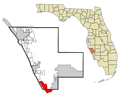 Location in Sarasota County and the state of Florida | |
| Coordinates: 26°57′47″N 82°21′7″W | |
| Country | |
| State | |
| Counties | Sarasota, Charlotte |
| Platted | 1896[1] |
| Area | |
| • Total | 13.1 sq mi (33.8 km2) |
| • Land | 9.8 sq mi (25.4 km2) |
| • Water | 3.3 sq mi (8.5 km2) |
| Elevation | 10 ft (3 m) |
| Population (2010) | |
| • Total | 14,863 |
| • Density | 1,518/sq mi (586.0/km2) |
| Time zone | UTC−05:00 (Eastern (EST)) |
| • Summer (DST) | UTC−04:00 (EDT) |
| ZIP Codes | 34223, 34224, 34295 |
| Area code(s) | 941 |
| FIPS code | 12-20825[2] |
| GNIS feature ID | 0282217 |
| [2] | |
The Sarasota County portion of Englewood is part of the Bradenton–Sarasota–Venice Metropolitan Statistical Area, while the Charlotte County portion is part of the Punta Gorda Metropolitan Statistical Area.
History
Englewood was platted in the 1890s.[1] A post office has been in operation at Englewood since 1895.[4]
Geography
According to the United States Census Bureau, the CDP has a total area of 13.1 square miles (33.8 km2), of which 9.8 square miles (25.4 km2) is land and 3.3 square miles (8.5 km2), or 24.99%, is water.[3]
Demographics
| Historical population | |||
|---|---|---|---|
| Census | Pop. | %± | |
| 1970 | 3,549 | — | |
| 1980 | 7,657 | 115.8% | |
| 1990 | 15,025 | 96.2% | |
| 2000 | 16,196 | 7.8% | |
| 2010 | 14,863 | −8.2% | |
| Source:[5] | |||
As of the 2000 U.S. Census, there were 16,196 people, 8,291 households, and 5,206 families in the CDP. The population density was 1,647.6 people per square mile (636.1/km2). There were 10,495 housing units at an average density of 1,067.6/sq mi (412.2/km2). The racial makeup of the CDP was 98.25% White, 0.19% African American, 0.25% Native American, 0.36% Asian, 0.01% Pacific Islander, 0.40% from other races, and 0.54% from two or more races. Hispanic or Latino of any race were 1.49% of the population.
Of the 8,291 households 10.7% had children under the age of 18 living with them, 55.4% were married couples living together, 5.3% had a female householder with no husband present, and 37.2% were non-families. Of households, 32.0% were one person and 21.7% were one person aged 65 or older. The average household size was 1.94 and the average family size was 2.36.
The age distribution was 10.3% under the age of 18, 3.2% from 18 to 24, 14.1% from 25 to 44, 26.0% from 45 to 64, and 46.4% 65 or older. The median age was 63 years. For every 100 females, there were 88.7 males. For every 100 females age 18 and over, there were 86.9 males.
The median household income was $31,808, the median family income was $38,978. Males had a median income of $26,568 versus $21,242 for females. The per capita income for the CDP was $23,462. About 5.5% of families and 8.7% of the population were below the poverty line, including 17.8% of those under age 18 and 4.9% of those age 65 or over.
Education
The Englewood Community Redevelopment Area (CRA) is a special district created by the Sarasota County Board of County Commissioners in 1999 on the Sarasota side of Englewood. The Sarasota and Charlotte County School Districts have an interlocal agreement allowing some Charlotte County residents to use the Englewood Elementary School and the Sarasota County students to use the Middle and High School located in Charlotte County. Englewood has a private utility company, the Englewood Water District, and the Englewood Fire District that serve the community.
Englewood contains multiple public elementary schools and one public high school (Lemon Bay High School). Several private schools are also located within Englewood. Englewood Christian Academy and Heritage Christian Academy both offer grades K–12. L.A. Ainger Middle School, a public school serving grades 6–8, located in nearby Rotonda West, Florida, is the nearest public middle school.
Popular entertainment includes the beach, restaurants, and a small shopping district located primarily along Dearborn Street.
References
- "Englewood's beginnings". Sarasota Herald-Tribune. August 30, 1995. p. 10. Retrieved November 3, 2015.
- "Englewood". Geographic Names Information System. United States Geological Survey. October 19, 1979. Retrieved January 17, 2019.
- "Geographic Identifiers: 2010 Demographic Profile Data (G001): Englewood CDP, Florida". U.S. Census Bureau, American Factfinder. Archived from the original on February 12, 2020. Retrieved April 11, 2013.
- "Sarasota County". Jim Forte Postal History. Archived from the original on January 17, 2016. Retrieved November 1, 2015.
- "Census of Population and Housing". U.S. Census Bureau. Retrieved January 15, 2019.
External links
| Wikimedia Commons has media related to Englewood, Florida. |
- Englewood Area Chamber of Commerce
- History of Englewood, Florida
- Englewood Community Redevelopment Area (CRA)
- Stump Pass Beach State Park at Florida State Parks
Municipalities and communities of Charlotte County, Florida, United States | ||
|---|---|---|
| City | 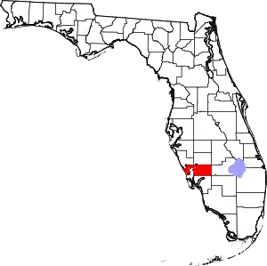 | |
| CDPs | ||
| Unincorporated communities | ||
| Ghost town | ||
| Footnotes | ‡This populated place also has portions in an adjacent county or counties | |
| ||
Municipalities and communities of Sarasota County, Florida, United States | ||
|---|---|---|
| Cities | 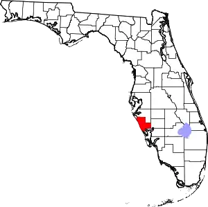 | |
| Town | ||
| CDPs | ||
| Unincorporated communities | ||
| Footnotes | ‡This populated place also has portions in an adjacent county or counties, †This populated place also has portions in the City of North Port | |
| ||