Export, Pennsylvania
Export is a borough in Westmoreland County, Pennsylvania, United States, surrounded entirely by the Municipality of Murrysville. The population was 917 at the 2010 census.
Export, Pennsylvania | |
|---|---|
Borough | |
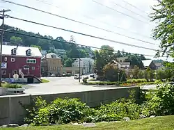 Export's business district | |
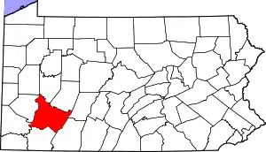
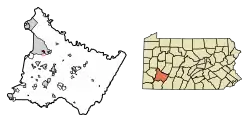 Location of Export in Westmoreland County, Pennsylvania. | |
 Export, Pennsylvania Location of Export in Westmoreland County, Pennsylvania. | |
| Coordinates: 40°24′59″N 79°37′25″W | |
| Country | United States |
| State | Pennsylvania |
| County | Westmoreland |
| Incorporated | November 11, 1911 |
| Government | |
| • Type | Borough Council |
| Area | |
| • Total | 0.40 sq mi (1.04 km2) |
| • Land | 0.40 sq mi (1.04 km2) |
| • Water | 0.00 sq mi (0.00 km2) |
| Elevation | 1,027 ft (313 m) |
| Population (2010) | |
| • Total | 917 |
| • Estimate (2019)[2] | 856 |
| • Density | 2,124.07/sq mi (819.29/km2) |
| Time zone | UTC−5 (Eastern (EST)) |
| • Summer (DST) | UTC−4 (EDT) |
| Zip code | 15632 |
| Area code(s) | 724, 878 |
| FIPS code | 42-24432 |
| Website | exportpennsylvania |
History
A post office called Export has been in operation since 1892.[3] The borough was so named because coal was once mined in and exported from the town.[4]
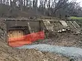
The remains of Westmoreland Coal Company's South (#2) mine are still visible behind the District Court building in Export. A 2018 project unearthed three entrances. A fourth entrance was discovered in January 2019 by Michael Mance and Lou Corsi.[5]
Geography
Export is located at 40°24′59″N 79°37′25″W (40.416251, -79.623679).[6]
According to the United States Census Bureau, the borough has a total area of 0.4 square miles (1.0 km2), all land.
Education
Export is within the Franklin Regional School District. The district consists of three elementary schools (Sloan, Newlonsburg, Heritage), Franklin Regional Middle School, and Franklin Regional High School. Export is also home to Free Gospel Bible Institute, an international Ministerial and Missionary College founded in 1958.
Demographics
| Historical population | |||
|---|---|---|---|
| Census | Pop. | %± | |
| 1920 | 2,596 | — | |
| 1930 | 2,184 | −15.9% | |
| 1940 | 1,990 | −8.9% | |
| 1950 | 1,690 | −15.1% | |
| 1960 | 1,518 | −10.2% | |
| 1970 | 1,371 | −9.7% | |
| 1980 | 1,143 | −16.6% | |
| 1990 | 981 | −14.2% | |
| 2000 | 895 | −8.8% | |
| 2010 | 917 | 2.5% | |
| 2019 (est.) | 856 | [2] | −6.7% |
| Sources:[7][8][9] | |||
As of the census[8] of 2000, there were 895 people, 455 households, and 232 families living in the borough. The population density was 2,346.5 people per square mile (909.4/km2). There were 513 housing units at an average density of 1,345.0 per square mile (521.2/km2). The racial makeup of the borough was 98.44% White, 0.11% African American, 0.67% Asian, and 0.78% from two or more races. Hispanic or Latino of any race were 0.56% of the population.
There were 455 households, out of which 22.0% had children under the age of 18 living with them, 32.1% were married couples living together, 12.1% had a female householder with no husband present, and 49.0% were non-families. 43.7% of all households were made up of individuals, and 21.1% had someone living alone who was 65 years of age or older. The average household size was 1.97 and the average family size was 2.74.
In the borough the age distribution of the population shows 18.8% under the age of 18, 6.0% from 18 to 24, 33.2% from 25 to 44, 18.8% from 45 to 64, and 23.2% who were 65 years of age or older. The median age was 41 years. For every 100 females, there were 90.4 males. For every 100 females age 18 and over, there were 85.9 males.
The median income for a household in the borough was $28,350, and the median income for a family was $36,591. Males had a median income of $30,677 versus $22,031 for females. The per capita income for the borough was $20,170. About 3.1% of families and 7.6% of the population were below the poverty line, including 2.2% of those under age 18 and 6.9% of those age 65 or over.
Notable people
- Scott McKillop, NFL linebacker for the San Francisco 49ers
- Bob Moose, former Pittsburgh Pirates player.[10]
- Jimmy Ripple, former New York Giants, Brooklyn Dodgers, Cincinnati Reds and Philadelphia Athletics player.[11]
Photo gallery
The following are the remains of Westmoreland Coal Company's South (#2) mine in Export.
 Entrances
 Entrance uncovered in January 2019
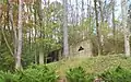 Fan house
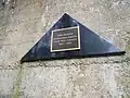 Plaque
References
- "2019 U.S. Gazetteer Files". United States Census Bureau. Retrieved July 28, 2020.
- "Population and Housing Unit Estimates". United States Census Bureau. May 24, 2020. Retrieved May 27, 2020.
- "Westmoreland County". Jim Forte Postal History. Retrieved 20 May 2015.
- Baker, Lawrence B. (Jul 14, 1969). "Rodney, Oscar, Cecil, Esther Surround Us". Pittsburgh Post-Gazette. p. 23. Retrieved 20 May 2015.
- Varine, Patrick. "New discovery made at Export mine". Trib Total Media LLC. Tribune-Review. Retrieved 6 January 2019.
- "US Gazetteer files: 2010, 2000, and 1990". United States Census Bureau. 2011-02-12. Retrieved 2011-04-23.
- "Census of Population and Housing". U.S. Census Bureau. Retrieved 11 December 2013.
- "U.S. Census website". United States Census Bureau. Retrieved 2008-01-31.
- "Incorporated Places and Minor Civil Divisions Datasets: Subcounty Resident Population Estimates: April 1, 2010 to July 1, 2012". Population Estimates. U.S. Census Bureau. Archived from the original on 11 June 2013. Retrieved 11 December 2013.
- Taken from Baseball-Reference.com
- Taken from Baseball-Reference.com
External links
| Counties |  Map of the Pittsburgh Tri-State with green counties in the metropolitan area and yellow counties in the combined area | |
|---|---|---|
| Major cities | ||
| Cities and towns 15k–50k (in 2010) | ||
| Airports | ||
| Topics | ||
| ||
| Authority control |
|---|