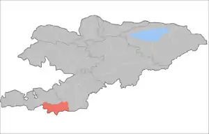
Chong-Alay District
Chong-Alay District (big Alay) (Kyrgyz: Чоң Алай району; Russian: Чон-Алайский район) is a raion (district) of Osh Region in far south-western Kyrgyzstan. The capital lies at Daroot-Korgon.[2] Its area is 4,857 square kilometres (1,875 sq mi), and its resident population was 25,039 in 2009.[1] The Chong-Alay District include 3 rural communities (ayıl ökmötü): Chong-Alay, Kashka-Suu, and Jekendi.[3]
Chong-Alay | |
|---|---|
 The border between Chong-Alay district and Alay district | |
 | |
| Country | Kyrgyzstan |
| Region | Osh Region |
| Area | |
| • Total | 4,857 km2 (1,875 sq mi) |
| Population (2009)[1] | |
| • Total | 25,039 |
| • Density | 5.2/km2 (13/sq mi) |
| Time zone | UTC+5 (GMT +5) |
Geography
Chong-Alay District occupies the western part of Alay Valley. The northern boundary of the district is located at Alay Mountains, and southern - at Trans-Alay Range. The valley is inclined from east to west, with the lowest point at 1560 meters above sea level.[4]
Climate is sharply continental with cold winters. Annual precipitation is 500–650 mm. Average temperature in July is +19-22C, and December -10-15C.[5]
The hydrology is dominated by the river Kyzyl-Suu (flowing towards the west) and its tributaries.
Demographics
| Year | Pop. | ±% |
|---|---|---|
| 1970 | 7,892 | — |
| 1979 | 10,018 | +26.9% |
| 1989 | 14,689 | +46.6% |
| 1999 | 21,655 | +47.4% |
| 2009 | 23,598 | +9.0% |
| Note: enumerated de facto population; Source:[1] | ||
Ethnic composition
According to the 2009 Census, the ethnic composition of the Chong-Alay District (de jure population) was:[1]
| Ethnic group | Population | Proportion of Chong-Alay District population |
|---|---|---|
| Kyrgyzs | 25,039 | 99.9% |
| other groups | 11 | 0.1% |
Populated places
In total Chong-Alay District comprised 22 settlements in 3 rural communities (aiyl okmotus).[1] Each rural community can consist of one or several villages. The rural communities and settlements in the Chong-Alay District are:[6]
- Jekendi aiyl okmotu (5: center - village: Karamyk; and also villages Jekendi, Kara-Teyit, Shibee and Chuluk)
- Kashka-Suu aiyl okmotu (5: center - village: Kashka-Suu; and also villages Achyk-Suu, Kabyk, Kara-Kabak and Burgan-Suu)
- Chong-Alay aiyl okmotu (12: center - village: Daroot-Korgon; and also villages Jash-Bashy, Jashtilek, Jaman-Jar, Kochkorchu, Kulchu, Kyzyl-Tuu, Sary-Bulak, Chak, Kyzyl-Eshme and Kara-Shybak)
References
- "2009 population census of the Kyrgyz Republic: Osh Region" (PDF). Archived from the original (PDF) on 10 August 2011. Retrieved 1 April 2011.
- "Administrative sub-division of Kyrgyzstan (map)". Enrin.grida.no. Archived from the original on 2009-08-02. Retrieved 2010-03-14.
- "List of rural communities of Kyrgyzstan". Archived from the original on 2010-02-09. Retrieved 2010-03-14.
- Ошская область:Энциклопедия [Encyclopedia of Osh Oblast] (in Russian). Bishkek: Chief Editorial Board of Kyrgyz Soviet Encyclopedia. 1987. p. 446.
- "State Administration of Osh Oblast (in Russian)". Archived from the original on 2009-01-05. Retrieved 2010-03-14.
- List of Rural Communities of Kyrgyzstan Archived 2010-02-09 at the Wayback Machine
| North Kyrgyzstan |
|  Raions of Kyrgyzstan | ||||||||||
|---|---|---|---|---|---|---|---|---|---|---|---|---|
| South Kyrgyzstan |
| |||||||||||
