Eyrecourt
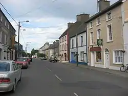
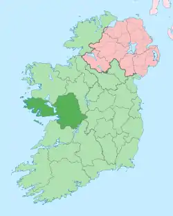
Eyrecourt, historically known as Donanaghta (Irish: Dún an Uchta),[2] is a village in County Galway, Ireland. Eyrecourt is on the R356 regional road 12 km west of the Banagher bridge over the River Shannon.
Eyrecourt
Dún an Uchta | |
|---|---|
Village | |
 Main Street, Eyrecourt | |
 Eyrecourt Location in Ireland | |
| Coordinates: 53.2°N 8.132°W | |
| Country | Ireland |
| Province | Connacht |
| County | County Galway |
| Elevation | 55 m (180 ft) |
| Population (2016)[1] | 252 |
| Time zone | UTC+0 (WET) |
| • Summer (DST) | UTC-1 (IST (WEST)) |
| Irish Grid Reference | M911163 |
History
The Eyres after whom the village is named, as well as other places such as Eyre Square in Galway City, were an English family who came over with Cromwell.[3] Their former residence, Eyrecourt Castle (now a ruin),[4] provides the large metal gateway at the eastern end of main street and the 100-acre (0.40 km2) castle lawn beyond. The family were for many years closely associated with the local hunt, the Galway Blazers.
Amenities
The village stands midway along the Beara-Breifne Way; a historic way-marked way for walking, cycling and heritage. Eyrecourt is served by two public houses, library, shop, garage and fast food outlet, pharmacy, tractor dealership, medical centre, primary school, several small enterprises and the Meelick-Eyrecourt GAA club. Various groups and classes use the village hall, including for Pilates, martial arts, scouting, art classes, badminton and other sports. Local sporting clubs include a kayaking club.[5]
Every second year in June the village hosts a festival of early machinery, the "Eyrecourt Vintage Festival", when old tractors, steam-engines and early farm machines are displayed. Each September Eyrecourt also hosts an agricultural show, which includes livestock shows and baking and gardening competitions.[6]
Eyrecourt is approximately 70 km (1 hour by car) from Galway and 150 km (2 hours by car) from Dublin.
Parish
The parish of Eyrecourt in south east County Galway incorporates the ancient ecclesiastical centres of Dunanaughta, Clonfert and Meelick and is bounded by the Rivers Shannon and Suck for 16 miles (26 km).
Within Dunanaughta there are two churches; the Catholic Church of St Brendan which has some notable stained glass windows,[8] (the work of John Early of Dublin) and the Church of Ireland Church of St John the Baptist (an Anglo Gothic structure built in 1867).[9] Meelick has the oldest Catholic church in Ireland with continuous use since 1414 AD. Clonfert has the grave of Saint Brendan "The Navigator" and Clonfert Cathedral (with its architecturally notable doorway), and a 14th-century statue of "Our Lady of Clonfert".
Notable people
- Charles Burton, High Court judge
- Cornelius Coughlan, Victoria Cross recipient
- Roger Whittaker, singer-songwriter (born in Nairobi but lived in Eyrecourt)
- Joe Salmon, Galway hurler grew up in Eyrecourt
See also
- List of towns and villages in Ireland
- List of steam fairs
- Market Houses in Ireland
References
- "Sapmap Area - Settlements - Eyrecourt". Census 2016. Central Statistics Office. April 2016. Retrieved 22 December 2019.
- "Dún an Uchta - Eyrecourt". Irish Placenames Database. Retrieved 1 May 2015.
- Eyrecourt. Pigot's Directory of Ireland. Pigot & Company. 1824. p. 204.
- "Eyrecourt Castle". Landedestates.ie. Retrieved 1 May 2015.
- "Meelick-Eyrecourt Kayak Club - Covering the Mid-Shannon". meelickeyrecourtkayakclub.com. Retrieved 17 November 2018.
- "Eyrecourt Agricultural Show website". Eyrecourt Agricultural Show committee. Archived from the original on 19 December 2014. Retrieved 1 May 2015.
- "Gouesnach - Eyrecourt" (in French). Website of the Brittany-Ireland Association.
- "Saint Brendan's Church, The Mall, Eyrecourt, County Galway". National Inventory of Architectural Heritage. Department of Environment, Heritage and Local Government. Retrieved 13 November 2011.
- "Saint John the Baptist Church, Church Lane, Eyrecourt, County Galway". National Inventory of Architectural Heritage. Department of Environment, Heritage and Local Government. Retrieved 13 November 2011.

