Falls Road station
Falls Road station is a Baltimore Light Rail station near Baltimore, Maryland. It is the first stop in surrounding suburban Baltimore County while traveling north from downtown Baltimore. The stop is located near the Mount Washington neighborhood in the Jones Falls Valley, and is often used by commuters as a back-up to Mount Washington for parking when the lot at Mt. Washington is full. The station is adjacent to Lake Roland Park and Dam (renamed Robert E. Lee Park in the 1940s), constructed in the late 1850s as part of the first segment of the city's new public water supply system in 1860 along the upper Jones Falls stream which flows south through the city emptying into the Inner Harbor of the Patapsco River of Baltimore Harbor and can be viewed from certain parts of the park. Although only used for several decades as part of the metropolitan area's public water system until shifting in the 1880s to a larger flowing supply piped from the Gunpowder Falls and construction of the first phase at the Loch Raven Reservoir and its taller Dam. Old Lake Roland and Dam are still owned by the City of Baltimore's Department of Recreation and Parks with its surrounding forested watershed, it is now operated and managed by its partner agency, the Baltimore County Department of Recreation and Parks through a recent contract agreement.
Falls Road | |||||||||||
|---|---|---|---|---|---|---|---|---|---|---|---|
| Baltimore Light Rail station | |||||||||||
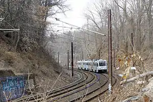 A light rail train near Falls Road | |||||||||||
| Location | 6101A Falls Road Baltimore, Maryland | ||||||||||
| Coordinates | 39.3759°N 76.6540°W | ||||||||||
| Owned by | Maryland Transit Administration | ||||||||||
| Platforms | 2 side platforms | ||||||||||
| Tracks | 2 | ||||||||||
| Connections | |||||||||||
| Construction | |||||||||||
| Parking | 110 free spaces | ||||||||||
| Disabled access | Yes | ||||||||||
| History | |||||||||||
| Opened | 1992 | ||||||||||
| Passengers | |||||||||||
| 2017 | 412 daily[1] | ||||||||||
| Services | |||||||||||
| |||||||||||
The stop is built near the former location of the old Bare Hills Station on the defunct Northern Central Railway (founded 1829 as the Baltimore and Susquehanna Railroad as the second rail line in that new concept of transportation to go out from the city (after the B. & O. Railroad in 1827), which ran south from the state capital Harrisburg, Pennsylvania through York until the mid 1950s and a large portion of which now is a hiking / biking trail and continues south through the valley as the "Jones Falls Trail" to the center city. A northwestern spur line of the Western Maryland Railway ran nearby past Lake Roland in the late 19th century towards Westminster, county seat in Carroll County from Relay House in Baltimore County.[2]
Bus service
Bus Route 60 operates on Falls Road past the stop on weekdays, but is a long walk from the station platform. The stop has 110 parking spaces for commuters.[3]
Station layout
| G | |
| Side platform, doors will open on the right | |
| Southbound | ← Light Rail toward BWI Airport or Glen Burnie (Mount Washington) |
| Northbound | Light Rail toward Fairgrounds or Hunt Valley (Lutherville) → |
| Side platform, doors will open on the right | |
| Street level | Exit/entrance and parking |
Nearby places and attractions
- Boys' Latin School of Maryland, Lake Avenue
- St. Paul's School, Brooklandville
- Lake Roland Park and Dam (formerly Robert E. Lee Park)
- Paw Point Dog Park
- Mount Washington village/neighborhood
References
- https://s3.amazonaws.com/mta-website-staging/mta-website-staging/files/Transit%20Projects/Cornerstone/LRCP_LightRailLink.pdf
- File:PRR 1955 schedule.jpg
- "Station list". Archived from the original on 2008-06-13.
