Garboldisham
Garboldisham (/ˈɡɑːrbəlʃəm/)[3] is a village and civil parish, part of Guiltcross in the Breckland district, in Norfolk, England, near the boundary with Suffolk. In the 2001 census the parish had a population of 721[4] which increased to 969 at the 2011 Census.
| Garboldisham | |
|---|---|
 Garboldisham Windmill | |
 Garboldisham Location within Norfolk | |
| Area | 11.17 km2 (4.31 sq mi) |
| Population | 721 (2001 census[1]) 969 2011 [2] |
| • Density | 65/km2 (170/sq mi) |
| OS grid reference | TM005815 |
| Civil parish |
|
| District | |
| Shire county | |
| Region | |
| Country | England |
| Sovereign state | United Kingdom |
| Post town | DISS |
| Postcode district | IP22 |
| Dialling code | 01953 |
| Police | Norfolk |
| Fire | Norfolk |
| Ambulance | East of England |
| UK Parliament | |
Origin of name
A D Mills (2003) says it was a 'homestead or village of a man called Gǣrbald'.[5] It appeared in the Domesday Book (1086) as Gerboldesham. The traditional view of Gaerbold is that it is an Old English name, i.e. homestead of Garbold. Others argue it has a Viking origin with Garbold being a famous Viking.[6] As described above, the boundary between Anglian, Viking and possibly even Iceni is blurred in the light of recent genetic and linguistic research.
To the south of the village are the hamlets of Smallworth and Broomscot Common, the name of the latter according to some recalling the village's ancient pagan past, but more likely, so Carole Hough thinks, an affiliation to a Scandinavian with the surname Brun.[7] This name might reflect the Viking invasions or Scandinavian connections of the Wuffingas, founders of the kingdom of East Anglia. It might even go further back in time if you believe theories that the pre-Roman Iceni inhabiting this area were Old English speakers rather than Cymric/Welsh.[8]
Notable buildings
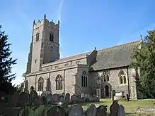
The village contains a Post Office with independent shop, selling a range of groceries as well as East Anglian regional "gourmet" produce. On Church Road is Garboldisham Church of England School, a primary school with about 90 pupils. The school is next to Garboldisham's St John the Baptist Church and opposite the village hall.
About 200 yards north is the ruined Garboldisham All Saints Church, where the 14th century western face collapsed into the nave in 1734.
There is also a small Methodist chapel, situated south of the A1066.
The Fox public house, on the crossroads of the A1066 and Hopton/Harling Road, closed in 2007 but was purchased by a village consortium in 2016 and reopened in December that year.[9]
Garboldisham Manor was a substantial house designed by George Gilbert Scott junior in the Jacobean style. The hall was demolished in 1952.
Village life
Garboldisham has active cricket teams.
The "Garboldisham Road" was mentioned in the A Bit of Fry and Laurie sketches "Information"[10] and "Strawberries and Cream".[11]
There is a 10-foot high Bronze Age round barrow on Garboldisham Heath, known locally as 'Soldier's Hill' and 'Boadicea's Grave', although there is no evidence that Queen Boudicca is buried here.[12] Local antiquarian Basil Brown carried out an excavation at the mound around 1963, and uncovered a burial urn, some cremated human bone, two flint flakes and a flint scraper. The burial probably dates from around 1300 BC.[13]
John Winston Spencer-Churchill, 7th Duke of Marlborough and grandfather of Sir Winston Churchill, was born in Garboldisham Hall in 1822.
References
| Wikimedia Commons has media related to Garboldisham. |
- Census population and household counts for unparished urban areas and all parishes. Office for National Statistics & Norfolk County Council (2001). Retrieved 20 June 2009.
- "Civil Parish population 2011". Neighbourhood Statistics. Office for National Statistics. Retrieved 4 August 2016.
- "Linguistic Notes on Norwich and Norfolk Place-names for Language and Communication Students". University of East Anglia. Retrieved 31 July 2020.
- "Neighbourhood Statistics: 2001 Census: Key Statistics: Parish Headcounts: Area: Garboldisham CP (Parish)". Office for National Statistics. Retrieved 3 June 2008.
- "A. D. MILLS. "Garboldisham." A Dictionary of British Place-Names". Oxford University Press. 2003. |Encyclopedia.com. 6 June 2009.
- "Y - DNA: Paternal - FAUX".
- "Hough, C. (1998). OE Brūn in Place-Names. English Studies 79: 512-521". Cite journal requires
|journal=(help) - The Origins of the British: A Genetic Detective Story by Stephen Oppenheimer, 2006. Carroll & Graf Publishing. ASIN 0786718900.
- Murphy, Rebecca. "The Fox Inn at Garboldisham is ready for patrons". Eastern Daily Press. Retrieved 7 April 2017.
- "Information". A Bit of Fry & Laurie. Retrieved 15 April 2018.
- "A Bit of Fry and Laurie English Strawberries on the Garboldisham Road".
- "NHER 6112: Bronze Age round barrow and cremation, known as 'Soldier's Hill' and 'Boadicea's Grave'". Norfolk Heritage Explorer.
- Lawson, Andrew; Tomalin, David (1986). Lawson, Andrew (ed.). Notes on Three Norfolk Barrow Excavations at Bridgham, Cockley Cley and Old Hunstanton with a Note on a Barrow Excavation at Garboldisham. Barrow excavations in Norfolk 1950–82. East Anglian Archaeology. pp. 104–113.