Saham Toney
Saham Toney is a village and a civil parish in the English county of Norfolk. The village is 14.5 miles (23.3 km) North of Thetford, 27.3 miles (43.9 km) west of Norwich and 101 miles (163 km) north-east of London. The village lies 13.1 miles (21.1 km) west of the town of Attleborough. The nearest railway station is at Attleborough for the Breckland Line which runs between Cambridge and Norwich. The nearest airport is Norwich International Airport. The civil parish has an area of 16.51 km2 (6.37 sq mi) and in 2001 had a population of 1565 in 680 households, reducing to 1,507 in 679 households at the 2011 Census. For the purposes of local government, the parish falls within the district of Breckland.
| Saham Toney | |
|---|---|
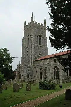 Saint George Parish Church, Saham Toney | |
 Saham Toney Location within Norfolk | |
| Area | 16.51 km2 (6.37 sq mi) |
| Population | 1,507 (2011 census)[1] |
| • Density | 91/km2 (240/sq mi) |
| OS grid reference | TF899020 |
| • London | 101 miles (163 km) |
| Civil parish |
|
| District | |
| Shire county | |
| Region | |
| Country | England |
| Sovereign state | United Kingdom |
| Post town | THETFORD |
| Postcode district | IP25 |
| Dialling code | 01953 |
| Police | Norfolk |
| Fire | Norfolk |
| Ambulance | East of England |
| Website | |
History
There is evidence[2] that Saham Toney was close to a significant Romano-British settlement. The Peddars Way footpath, partly using remaining Roman roads, passes close to the village.
The village derives part of its name[3] from the 13-acre (53,000 m2) mere that is in the parish. The mere is well stocked with fish especially eels of two species, one noted for their delicious, and the other for their nauseous flavour, also one is of a peculiar shape. There are also large pike in the mere. The privately owned mere which is dangerous is thought to be as old as the last Ice Age. Access is by special permission of the owner only.
Etymology
Saham Toney derives the first part of its name from the Old English meaning homestead by the lake. However, toney refers to the fact the land was owned by Ralph de Toeni, standard-bearer of William I, in the period shortly after the Norman conquest.[4]
Village amenities
Amenities in the village include a public house, hotel and Parker’s VC C of E Primary school attended by over 100 pupils.
The Parish Church of Saint George
The Parish Church of Saint George is constructed from flint and has a 15th-century tower containing 6 bells and a clock.[3] The Church has some very beautiful stained glass windows, the east window of the chancel portrays the Last Supper, this was a gift by the late Rev. W. H. Parker, who restored the whole building at considerable expense in 1864. The nave arcades, clerestory, and part of the chancel date from the 14th century.
Notable residents
Former British Prime Minister John Major was evacuated to the village from 1944–45 as an infant to avoid the war.[5]
Frank Lee Woodward (1871–1952), an English educationist, Pali scholar, author and theosophist.
References
| Wikimedia Commons has media related to Saham Toney. |
- "Civil Parish population 2011". Neighbourhood Statistics. Office for National Statistics. Retrieved 11 August 2016.
- Webster, Graham. "The Roman Invasion of Britain". Batsford London 1993. Archived from the original on 22 February 2014. Retrieved 26 April 2013.
- The King’s England, Norfolk, by Arthur Mee, Page 264 ISBN 0-340-15061-0
- "Parish Summary:Saham Toney". Norfolk Heritage Explorer. Retrieved 29 June 2017.
- Major, John, The Autobiography, pg. 8
- ^ Office for National Statistics & Norfolk County Council, 2001. Census population and household counts for unparished urban areas and all parishes. Retrieved December 2, 2005.