Glen Strathfarrar
Glen Strathfarrar (Scottish Gaelic: Srath Farair) is a glen in the Highland region of Scotland, near Loch Ness. Glen Strathfarrar is named for the River Farrar, which runs through the glen,[2] and which derives from the Pictish var (meaning "to wind"), and was known to the Romans as Varrar.[2] The full name is a curious 'Gaelicisation' of the Gaelic: as a strath is an elongated glen, a title of 'Glen Strath' is tautological, and it is therefore likely that an English-only speaker, ignorant of the meaning of 'Strath' when transcribing the map of the location, recorded that this was the 'Glen of Strathfarrar'.
| Glen Strathfarrar National Scenic Area | |
|---|---|
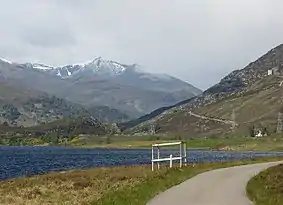 View along the glen across Loch Beannacharan, with Sgùrr na Lapaich beyond | |
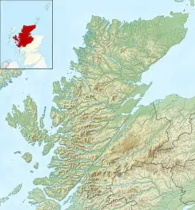 Glen Strathfarrar shown within the Highland council area. | |
| Location | Highland, Scotland |
| Coordinates | 57°24′51″N 4°50′21″W |
| Area | 40 km2 (15 sq mi)[1] |
| Established | 1981 |
| Governing body | NatureScot |
The Glen is part of the Affric-Beauly hydro-electric power scheme, with a dam at Loch Monar and a 9 km tunnel carrying water to an underground power station at Deanie; a second dam just below Loch Beannacharan feeds a tunnel carrying water to Culligran power station (also underground).[3] The Monar dam at Loch Monar is the largest arch dam in Britain.[2]
The central section of Glen Strathfarrar (covering 4027 ha[1]) is designated as a national scenic area,[4] one of forty such areas in Scotland, which have been defined so as to identify areas of exceptional scenery and to ensure its protection from inappropriate development.[5] The area covered by the NSA represents the section of the glen least affected by the hydro-electric scheme, and includes the Culligran Falls.[6]
Geography
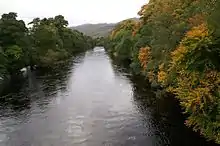
The River Farrar (Scottish Gaelic: Farar / Uisge Farair) is formed as the waters of the Uisge Misgeach and the Garbh-uisge merge around 2 km after the latter exits Loch Monar.[7] The river then adopts a sinuous course along the flat floor of the glen,[6] running eastwards through two lochs, Loch a' Mhuillidh and Loch Beannacharan, which is dammed as part of the Affric-Beauly hydro-electric power scheme.[8] The river then continues east, passing over Culligran Falls, before merging with the waters of the River Glass to form the River Beauly below Struy Bridge near the village of Struy.[7]
There are a number of mountains on either side of the glen, many of which are popular with walkers. These include the Munros of Sgùrr a' Choire Ghlais, Sgurr Fhuar-thuill, Càrn nan Gobhar and Sgurr na Ruaidhe to the north, as well as Sgùrr na Lapaich, another Càrn nan Gobhar, An Riabhachan and An Socach to the south.[9] There are also two Corbetts - Beinn a' Bha'ach Ard and Sgorr na Dìollaid.[10]
Naural heritage
Glen Strathfarrar contains several areas of Caledonian Forest,[11] the name given to the remnants of the old-growth temperate rainforest of Scotland composed chiefly of Scots pine trees that first colonised the area after the last Ice Age 8-10,000 years ago, and which forms an important habitat for species such as capercaillie, crested tit and the endemic Scottish crossbill.[12] Since the late 18th century commercial timber extraction (especially during the two world wars) and human settlement have contributed to the serious deterioration of the woodland.[2] In addition to the pinewood, there are areas of birch, and more open areas of heather, bracken and grass.[6] Red deer,[6] otters,[13] and golden eagles[14] are all known to inhabit the area, which also hosts several dragonfly species.[15]
Glen Strathfarrar is designated as part of both Special Protection Area and a Special Area of Conservation under the Natura 2000 programme, as well as being designated as a Site of Special Scientific Interest (SSSI).[16] The glen, along with the neighbouring glens of Glen Affric and Glen Cannich, was proposed for inclusion in a national park by the Ramsay Committee in 1945,[17] but this has not been actioned as of 2020.
History
A small island in Loch a' Mhuillidh holds the remains of a building used by Simon Fraser, 11th Lord Lovat on his flight from Culloden after the unsuccessful Jacobite Jacobite rising of 1745.[2] Following this rebellion the Highlands underwent massive social changes, and the introduction of sheep farming followed by the establishment of deer forests led to depopulation in the 19th century, a period known as the Highland clearances. The Affric-Beauly hydro-electric power scheme led to further depopulation in Strathfarrar, with only two buildings (the keeper's house at Monar and Pait Lodge) surviving the rising waters of Loch Monar.[2]
Access

The road along the glen is private, and a locked gate system operates whereby permission for motor vehicle access must be requested at the gatehouse. A quota of cars are allowed in the glen each day. Access times vary, according to the month, between 9am and 8pm. In the winter the only means of access is to contact Mountaineering Scotland who will give a security code for the gate.[18] The resulting relative lack of cars through the glen contributes to the remote and utter peace and calm, especially of the upper reaches of the glen toward Loch Monar.
As with all land in Scotland, there is a right of responsible access to most of the land in the glen,[19] and there is thus no restriction on access along the glen by foot, bicycle or other non-motorised transport.[18]
External links
References
| Wikimedia Commons has media related to Glen Strathfarrar. |
- "National Scenic Areas - Maps". SNH. 2010-12-20. Archived from the original on 2018-06-12. Retrieved 2018-01-24.
- "Glen Strathfarrar - Beautiful and Unspoiled". Strathglass Marketing. 2016. Retrieved 2018-03-09.
- "Power From the Glens" (PDF). Scottish and Southern Energy. p. 12. Archived from the original (PDF) on 2007-10-18. Retrieved 2008-03-08.
- "Glen Strathfarrar National Scenic Area". NatureScot. Retrieved 2 October 2020.
- "National Scenic Areas". NatureScot. Retrieved 2 October 2020.
- "The special qualities of the National Scenic Areas" (PDF). Scottish Natural Heritage. 2010. Retrieved 2018-03-06.
- Ordnance Survey 1:50,000 scale Landranger map sheets 25 Glen Carron and 26 Inverness
- "Affric/Beauly hydro scheme". Scottish and Southern Energy. Retrieved 25 January 2011.
- D. Bennet & R. Anderson. The Munros: Scottish Mountaineering Club Hillwalkers Guide, pp. 197-201. Published 2016.
- R. Milne & H Brown. The Corbetts and Other Scottish Hills - Scottish Mountaineering Club Hillwalkers' Guide, pp. 192-193. Published 2002.
- "Caledonian Pinewood Inventory". Forestry Commission Scotland. 2016-06-24. Retrieved 2018-02-28.
- "The Caledonian Forest". Trees for Life. 2017. Retrieved 2018-03-09.
- "Strathglass Complex SAC". NatureScot. Retrieved 2 October 2020.
- "Glen Affric to Strathconon SPA". NatureScot. Retrieved 2 October 2020.
- "Glen Strathfarrar SSSI". NatureScot. Retrieved 2 October 2020.
- "Sitelink - Map Search". NatureScot. Retrieved 2 October 2020.
- "Unfinished Business a national parks strategy for scotland" (PDF). Scottish Campaign for National Parks. March 2013. Retrieved 2018-03-17.
- "Strathfarrar Access Arrangements". Mountaineering Scotland. Retrieved 17 March 2018.
- "Scottish Outdoor Access Code" (PDF). www.outdooraccess-scotland.scot. Scottish Natural Heritage. 2005. Retrieved 2 October 2020.