Trotternish
Trotternish or Tròndairnis (Scottish Gaelic) is the northernmost peninsula of the Isle of Skye, in Scotland. Its most northerly point, Rubha Hùinis, is the most northerly point of Skye.
| Trotternish National Scenic Area | |
|---|---|
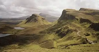 The Quiraing | |
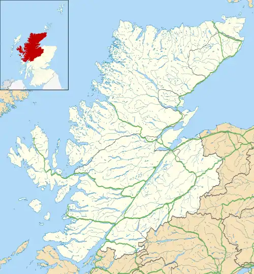 The Trotternish NSA, shown with the Highland council area | |
| Location | Isle of Skye, Scotland |
| Coordinates | 57°38′37″N 6°15′55″W |
| Area | 79 km2 (31 sq mi)[1] |
| Established | 1981 |
| Governing body | NatureScot |
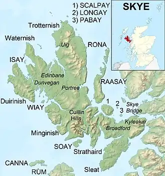
One of the peninsula's better-known features is the Trotternish landslip, a massive landslide that runs almost the full length of the peninsula, some 30 kilometres (20 miles).[2] The landslip contains two of Skye's most famous landmarks: the Old Man of Storr, an isolated rocky pinnacle, and the Quiraing, an area of dramatic and unusual rock formations. The summit of The Storr, on whose slopes the Old Man of Storr is located, is the highest point of the peninsula.[2] The north-eastern part of the peninsula around Quiraing is designated as a National Scenic Area and the entire landslip is a Special Area of Conservation.
Dinosaur footprints have been found at An Corran, which is also a Mesolithic hunter-gatherer site dating to the 7th millennium BC. The ruins of the 14th–15th-century Duntulm Castle stand at the northern end of the peninsula.
The three major settlements on Trotternish are Portree, generally regarded as the capital of Skye, Uig, a ferry terminus, and Staffin.[2] Trotternish is the strongest Gaelic-speaking area of Skye.
Geography and natural history

Trotternish is underlain by basalt, which provides relatively rich soils and a variety of unusual rock features. The Kilt Rock is named after the tartan-like patterns in the 105-metre (344-foot) cliffs. The Quiraing is a spectacular series of rock pinnacles on the eastern side of the main spine of the peninsula and further south is the rock pillar of the Old Man of Storr.[3] While having many vertical heights, the area is mainly unsuitable for rock-climbing due to the friable rock.
At An Corran near Staffin a local resident found a slab bearing a dinosaur track, probably made by a small ornithopod. Experts subsequently found more dinosaur prints of up to 50 cm, the largest found in Scotland, made by a creature similar to Megalosaurus. At about 160 million years old they are the youngest dinosaur remains to be found in Scotland.[4][5]
Conservation designations
The north-eastern part of the peninsula around Quiraing is designated as the Trotternish National Scenic Area,[6] one of the forty such areas in Scotland, which are defined so as to identify areas of exceptional scenery and to ensure its protection from inappropriate development.[7] The designated area covers 7,919 ha in total, of which 6,128 ha is on land, with a further 1789 ha being marine (i.e. below low tide level, and covering the seas to the east of the peninsula).[1]
The entire length of the Trotternish landslip is protected as a Special Area of Conservation (SAC) under the Natura 2000 programme,[8] and classified as a Category IV protected area by the International Union for Conservation of Nature.[9]
History
A Mesolithic hunter-gatherer site dating to the 7th millennium BC at An Corran in Staffin is one of the oldest archaeological sites in Scotland. Its occupation is probably linked to that of the rock shelter at Sand, Applecross, on the mainland coast of Wester Ross where tools made of a mudstone from An Corran have been found. Surveys of the area between the two shores of the Inner Sound and Sound of Raasay have revealed 33 sites with potentially Mesolithic deposits.[10][11]
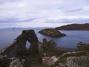
The ruined Duntulm Castle stands on a promontory at the northern end of the peninsula, near the hamlet of Duntulm.[12] During the 17th century it was the seat of the chiefs of Clan MacDonald of Sleat, and is a scheduled monument.[13] The castle is believed to stand on the site of a prehistoric broch or dun known as Dun David, or Dun Dhaibhidh, although no archaeological evidence has been found for this predecessor.[14] The castle was built in the 14th and 15th centuries, when the area was subject to feuds between the rival MacLeod and Macdonald clans, and was abandoned around 1732, when Sir Alexander MacDonald built a new residence, Monkstadt House, 5 miles (8 kilometres) to the south.[14]
Flodigarry north of Staffin was between 1750 and 1772 the home of Flora MacDonald, the Jacobite made famous by her part in Charles Edward Stuart's escape after his defeat at Culloden.[12] She later moved to Kingsburgh on the southwestern coast of Trotternish, and it was here that Boswell and Johnson met her during their tour of the Western Isles in 1773. Johnson, who held Jacobite views when younger,[15] commented that she was a woman of "soft features, gentle manners and elegant presence".[16]
Gaelic
In terms of number of speakers, Trotternish is the strongest Gaelic-speaking area of Skye. In the 2001 census, 61% of the population returned as Gaelic speakers,[17] there are Gaelic-medium units in the Staffin and Kilmuir primary schools, and the area is the focus of one of Comunn na Gàidhlig's Gaelic development initiatives, Lasair.[18] In 2010, Comunn na Gàidhlig named Staffin as their Gaelic Community of the Year.[19]
Transport
The main road in Trotternish is the A87, which runs between Portree at the southern end of the peninsula and Uig on the northwest coast.[2] Uig marks the northwestern terminus of the A87, with its southeastern terminus being the junction with the A82 at Invergarry, to the north of Fort William. The A855 road also links Portree and Uig, taking a route along the eastern coast and round the northern end of the peninsula: the two roads thus combine to encircle Trotternish. A minor road also crosses the peninsula, passing between Uig and Staffin via the Quiraing.[2]
Portree is the terminus for Scottish Citylink buses from Glasgow Buchanan bus station and Inverness, with some services continuing on to Uig.[20][21] Uig serves as the ferry terminal for Caledonian MacBrayne services to Tarbert on Harris and Lochmaddy on North Uist, providing links with the Outer Hebrides.[22][23]
Settlements in Trotternish
Gallery
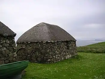 Blackhouse in The Skye Museum of Island Life on Trotternish
 The Storr
 Mealt waterfall at Ellishadder, with Kilt Rock behind
Notes
- "National Scenic Areas - Maps". Scottish Natural Heritage. 20 December 2010. Retrieved 26 June 2018.
- Ordnance Survey Landranger 1:50000 Map. Sheet 23. North Skye, Dunvegan & Portree.
- Murray, W. H. (1966). The Hebrides. London: Heinemann. p. 149.
- "Jurassic dinosaur footprints at An Corran". Scottish Geology. Retrieved 13 February 2011.
- Clark, Neil. "Dinosaurs in Trotternish" (PDF). staffin.net. Staffin Community Trust. Retrieved 13 February 2011.
- "The special qualities of the National Scenic Areas" (PDF). Scottish Natural Heritage. 2010. pp. 232–238. Retrieved 26 June 2018.
- "National Scenic Areas". NatureScot. Retrieved 5 October 2020.
- "Trotternish Ridge SAC". NatureScot. Retrieved 5 October 2020.
- "Trotternish Ridge in United Kingdom of Great Britain and Northern Ireland". Protected Planet. Retrieved 26 June 2018.
- Saville, Alan; Hardy, Karen; Miket, Roger; Ballin, Torben Bjarke "An Corran, Staffin, Skye: a Rockshelter with Mesolithic and Later Occupation" Archived 29 September 2012 at the Wayback Machine. Scottish Archaeology Internet Reports. Retrieved 15 December 2012.
- Wickham-Jones, C.R. and Hardy, K. "Scotlands First Settlers". History Scotland Magazine/Wayback Machine. Retrieved 15 December 2012.
- T. Marsh. The Isle of Skye. Cicerone. ISBN 978-1-85284-560-5. pp. 234-236.
- Historic Environment Scotland. "Duntulm Castle (SM5307)". Retrieved 16 April 2019.
- Historic Environment Scotland. "Duntulm Castle, Skye (11392)". Canmore. Retrieved 27 June 2018.
- S. Johnson & J. Boswell (ed. R. Black). To the Hebrides: "Journey to the Western Isles of Scotland" and "Journal of a Tour to the Hebrides", p. 227. Published by Birlinn, 2007.
- S. Johnson & J. Boswell (ed. R. Black). To the Hebrides: "Journey to the Western Isles of Scotland" and "Journal of a Tour to the Hebrides", pp. 169-170. Published by Birlinn, 2007.
- Mac an Tàilleir, Iain (2010) "A' Ghàidhlig anns a' Chunntas-shluaigh." ("Gaelic in the Census") In: Gillian Munro and Iain Mac an Tàilleir (Eds.) Coimhearsnachd na Gàidhlig an-Diugh ("Scots Gaelic Community Rim") , Edinburgh: Dunedin, pp.19-34
- "Iomairt Ghàidhlig an Eilein Sgitheanaich". Comunn na Gàidhlig. 8 May 2012. Retrieved 26 June 2018.
- "Staffin named as Gaelic Community of the Year". Comunn na Gàidhlig. 10 September 2010. Retrieved 26 June 2018.
- "Timetable: Isle of Skye, Fort William, Glen Coe, Loch Lomond, Glasgow (21st May - 30th September 2018)" (PDF). Scottish Citylink. Retrieved 26 June 2018.
- "Timetable: Isle of Skye and Inverness (21st May - 30th September 2018)" (PDF). Scottish Citylink. Retrieved 26 June 2018.
- "Summer Timetable, Harris: Uig - Tarbert". Calmac Ferries Ltd. Retrieved 26 June 2018.
- "Summer Timetable, North Uist: Uig - Lochmaddy". Calmac Ferries Ltd. Retrieved 26 June 2018.