Gore Bay, Ontario
Gore Bay is a town on Manitoulin Island in Ontario, Canada. Located on Gore Bay, a bay of Lake Huron's North Channel, it is one of the two incorporated towns of Manitoulin District, of which it is the administrative and government seat. The town's named is believed to be referencing to the gore-shaped harbour.[4] Other theories for the namesake are probably for Francis Gore (1769-1852), Lieutenant-Governor of Upper Canada from 1806-1817; or after the steamer Gore, which ran between Sault Ste. Marie and Collingwood from 1860 to 1870.[5]
Gore Bay | |
|---|---|
| Town of Gore Bay | |
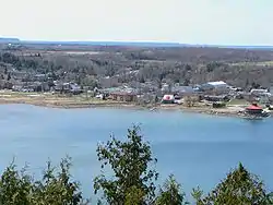
 Panorama of Gore Bay and the North Channel. | |
| Motto(s): Pristine, prosperous, proud. | |
 Gore Bay | |
| Coordinates: 45°55′N 82°28′W | |
| Country | Canada |
| Province | Ontario |
| District | Manitoulin |
| Government | |
| • Type | Town |
| • Mayor | Dan Osborne [1] |
| • Governing Body | Corporation of the Town of Gore Bay |
| • MP | Carol Hughes (NDP) |
| • MPP | Michael Mantha (NDP) |
| Area | |
| • Land | 5.23 km2 (2.02 sq mi) |
| Elevation | 193.50 m (634.84 ft) |
| Population (2016)[2] | |
| • Total | 867 |
| • Density | 165.7/km2 (429/sq mi) |
| Time zone | UTC-5 (EST) |
| • Summer (DST) | UTC-4 (EDT) |
| Postal code | P0P 1H0 |
| Area code(s) | 705 |
| Website | www.gorebay.ca |
During the summer months the population and activity of the town flourishes as boaters and tourists from around Ontario and the Great Lakes regions flock to the area. The areas surrounding Gore Bay are quickly becoming popular with cottagers and vacationers during the summer months.
Gore Bay is home to Manitoulin Transport, one of Canada's largest trucking companies. Craft brewer Split Rail Brewing is located in Gore Bay.
Notable people
- Major league pitcher Ken Mackenzie.
- National Hockey League player Bobby Burns.
Demographics
| Canada census – Gore Bay, Ontario community profile | |||
|---|---|---|---|
| 2016 | 2011 | ||
| Population: | 867 (2.0% from 2011) | 850 (-8.0% from 2006) | |
| Land area: | 5.23 km2 (2.02 sq mi) | 5.27 km2 (2.03 sq mi) | |
| Population density: | 165.7/km2 (429/sq mi) | 161.4/km2 (418/sq mi) | |
| Median age: | 56.1 (M: 53.8, F: 57.9) | ||
| Total private dwellings: | 447 | 414 | |
| Median household income: | |||
| References: 2016[6] 2011[7] earlier[8] | |||
Climate
Gore Bay experiences a humid continental climate (Dfb). The highest temperature ever recorded in Gore Bay was 37.8 °C (100 °F) on 13 July 1936.[9] The coldest temperature ever recorded was −38.9 °C (−38 °F) on 15 February 1943.[10]
| Climate data for Gore Bay-Manitoulin Airport, 1981−2010 normals, extremes 1915−present[lower-alpha 1] | |||||||||||||
|---|---|---|---|---|---|---|---|---|---|---|---|---|---|
| Month | Jan | Feb | Mar | Apr | May | Jun | Jul | Aug | Sep | Oct | Nov | Dec | Year |
| Record high °C (°F) | 9.4 (48.9) |
10.6 (51.1) |
22.2 (72.0) |
27.5 (81.5) |
30.6 (87.1) |
33.9 (93.0) |
37.8 (100.0) |
35.6 (96.1) |
34.4 (93.9) |
26.7 (80.1) |
20.0 (68.0) |
15.0 (59.0) |
37.8 (100.0) |
| Average high °C (°F) | −4.6 (23.7) |
−3.3 (26.1) |
1.2 (34.2) |
9.5 (49.1) |
16.2 (61.2) |
21.1 (70.0) |
24.8 (76.6) |
23.6 (74.5) |
18.2 (64.8) |
11.4 (52.5) |
4.9 (40.8) |
−1.3 (29.7) |
10.1 (50.2) |
| Daily mean °C (°F) | −9.5 (14.9) |
−8.3 (17.1) |
−3.7 (25.3) |
4.5 (40.1) |
10.8 (51.4) |
15.7 (60.3) |
19.5 (67.1) |
18.8 (65.8) |
14.0 (57.2) |
7.8 (46.0) |
1.7 (35.1) |
−5.0 (23.0) |
5.5 (41.9) |
| Average low °C (°F) | −14.3 (6.3) |
−13.2 (8.2) |
−8.6 (16.5) |
−0.5 (31.1) |
5.3 (41.5) |
10.2 (50.4) |
14.2 (57.6) |
13.9 (57.0) |
9.7 (49.5) |
4.1 (39.4) |
−1.6 (29.1) |
−8.7 (16.3) |
0.9 (33.6) |
| Record low °C (°F) | −37.5 (−35.5) |
−38.9 (−38.0) |
−32.3 (−26.1) |
−23.3 (−9.9) |
−7.8 (18.0) |
−1.7 (28.9) |
1.1 (34.0) |
0.0 (32.0) |
−3.9 (25.0) |
−9.4 (15.1) |
−26.1 (−15.0) |
−36.1 (−33.0) |
−38.9 (−38.0) |
| Average precipitation mm (inches) | 45.1 (1.78) |
29.8 (1.17) |
63.5 (2.50) |
67.1 (2.64) |
61.2 (2.41) |
64.7 (2.55) |
47.7 (1.88) |
65.1 (2.56) |
88.1 (3.47) |
107.3 (4.22) |
97.2 (3.83) |
70.5 (2.78) |
804.1 (31.66) |
| Average rainfall mm (inches) | 10.5 (0.41) |
4.1 (0.16) |
41.7 (1.64) |
56.7 (2.23) |
61.1 (2.41) |
64.7 (2.55) |
47.7 (1.88) |
65.1 (2.56) |
88.1 (3.47) |
105.8 (4.17) |
71.8 (2.83) |
28.6 (1.13) |
645.9 (25.43) |
| Average snowfall cm (inches) | 69.7 (27.4) |
47.0 (18.5) |
33.2 (13.1) |
14.0 (5.5) |
0.2 (0.1) |
0.0 (0.0) |
0.0 (0.0) |
0.0 (0.0) |
0.0 (0.0) |
2.0 (0.8) |
31.5 (12.4) |
80.2 (31.6) |
277.8 (109.4) |
| Average precipitation days (≥ 0.2 mm) | 17.7 | 12.1 | 11.1 | 12.7 | 11.7 | 11.7 | 9.0 | 11.1 | 13.3 | 14.6 | 15.9 | 17.8 | 158.8 |
| Average rainy days (≥ 0.2 mm) | 2.8 | 2.2 | 6.2 | 10.7 | 11.8 | 11.9 | 9.0 | 11.2 | 13.4 | 14.9 | 11.4 | 5.2 | 110.5 |
| Average snowy days (≥ 0.2 cm) | 17.7 | 11.9 | 7.7 | 3.9 | 0.2 | 0.0 | 0.0 | 0.0 | 0.0 | 0.7 | 7.0 | 15.9 | 64.9 |
| Source: Environment Canada[3][11][12][13][14] | |||||||||||||
Transportation
Highway 540A and Highway 540B are the main roads in the township.
Gore Bay-Manitoulin Airport is located in the town and one of two airports on Manitoulin Island. The airport is a general aviation facility.
See also
References
- "2018 Municipal Election". Town of Gore Bay. Retrieved 12 November 2018.
- "Gore Bay census profile". 2016 Census of Population. Retrieved 20 July 2018.
- "Gore Bay A". Canadian Climate Normals 1981–2010. Environment Canada. Retrieved 16 December 2016.
- https://www.manitoulintourism.com/portfolio/gore-bay/
- Hamilton, William (1978). The Macmillan Book of Canadian Place Names. Toronto: Macmillan. p. 149. ISBN 0-7715-9754-1.
- "2016 Community Profiles". 2016 Canadian Census. Statistics Canada. 21 February 2017. Retrieved 20 July 2018.
- "2011 Community Profiles". 2011 Canadian Census. Statistics Canada. 5 July 2013. Retrieved 24 February 2012.
- "2001 Community Profiles". 2001 Canadian Census. Statistics Canada. 17 February 2012.
- "Daily Data Report for July 1936". Canadian Climate Data. Environment Canada. Retrieved 16 December 2016.
- "Daily Data Report for February 1943". Canadian Climate Data. Environment Canada. Retrieved 16 December 2016.
- "Gore Bay". Canadian Climate Data. Environment Canada. Retrieved 16 December 2016.
- "Daily Data Report for March 2003". Canadian Climate Data. Environment Canada. Retrieved 16 December 2016.
- "Gore Bay AWOS". Canadian Climate Data. Environment Canada. Retrieved 16 December 2016.
- "Gore Bay Climate". Canadian Climate Data. Environment Canada. Retrieved 16 December 2016.
- Extreme high and low temperatures in the table below were recorded at Gore Bay from October 1915 to October 1983 and at Gore Bay Airport from November 1983 to present.
External links
Places adjacent to Gore Bay, Ontario | ||||||||||
|---|---|---|---|---|---|---|---|---|---|---|
| ||||||||||