Northeastern Manitoulin and the Islands
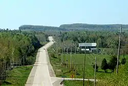
Northeastern Manitoulin and the Islands is a municipality with town status in Manitoulin District in Northeastern Ontario, Canada, approximately 30 kilometres (19 mi) south of Espanola. Its main town is Little Current, located on the northeast side of Manitoulin Island. However, its territory also includes most of the small islands surrounding Manitoulin, even those at the far western end of Manitoulin.
Northeastern Manitoulin and the Islands | |
|---|---|
| Town of Northeastern Manitoulin and the Islands | |
 | |
 Northeastern Manitoulin and the Islands | |
| Coordinates: 45°58′N 81°56′W | |
| Country | Canada |
| Province | Ontario |
| District | Manitoulin |
| Established | January 1, 1998 |
| Government | |
| • Type | Town |
| • Mayor | Alan MacNevin |
| • MP | Carol Hughes (NDP) |
| • MPP | Michael Mantha (NDP) |
| Area | |
| • Land | 495.68 km2 (191.38 sq mi) |
| Population (2011)[1] | |
| • Total | 2,706 |
| • Density | 5.5/km2 (14/sq mi) |
| Time zone | UTC-5 (EST) |
| • Summer (DST) | UTC-4 (EDT) |
| Postal code | P0P 1K0 |
| Area code(s) | 705 |
| Highways | |
| Website | www.townofnemi.on.ca |
The town was created on January 1, 1998, by amalgamating the Town of Little Current with the Township of Howland and the unorganized small islands in Lake Huron.
It is the administrative headquarters of the Aundeck Omni Kaning First Nations band government.[1]
Communities
Little Current is the largest community within the town, as well as its administrative centre. Formerly an independent town, Little Current was named variously by different groups for the swift strong currents of water running between the narrow passageway which connects the North Channel and Georgian Bay. Past names for the community included Waebijewung, Le Petit Courant and Shaftesbury.
The town also includes the smaller communities of Cold Springs, Dinner Point Depot, Eads Bush, Green Bay, Honora, Rockville, and Sheguiandah.
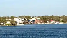 Little Current as seen across the North Channel |
 Water Street in Little Current |
Economy
In the late 19th century lake vessels stopped here to take on wood for fuel. A settlement developed, with George Abotossaway, an Anishinaabe man, selling fuel to the steamers. The westbound passengers on board the vessels were usually from Upper Canada. One group included the Turner family which disembarked and, being merchants, set up a general store still in business today.
The lumbering trade was foremost in the region at the time and saw mills were established at nearby Low Island, now a park in the community. Settlers cleared the land for farming.
Today the local economy continues to include farming and lumbering but tourism is a main aspect.
Transportation
Being a safe haven from the ravages of Lake Huron, the community may be found on Canadian Hydrographic Chart #2205. It is well marked from the east by Strawberry Island Lighthouse and from the west by a series of navigational markers.
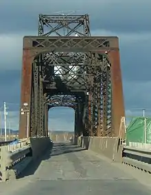
The only land access to Manitoulin is the Little Current Swing Bridge, located on Highway 6, crossing the North Channel of Lake Huron to the mainland, where the highway continues northward to Espanola. In summer the swing bridge opens to marine traffic on the hour for 15 minutes from sunrise to sunset, delaying road traffic.
Historically, Little Current was the western terminus of the Algoma Eastern Railway before the AER's acquisition by the Canadian Pacific Railway. After acquisition, the portion from McKerrow to Little Current was designated as the Little Current subdivision of the CPR, and became a spur of its Sault Ste. Marie line. Passenger rail ridership through Espanola and Little Current continued for some time due to the relatively difficult road access to the island, but passenger operations along the spur ended in 1963, and the line became an infrequently-used "ghost railway". Over the following decades, the CPR gradually removed sections of the track: in the 1980s, the section connecting Goat Island to Manitoulin Island across the Little Current Swing Bridge (which was converted to service road traffic only), and in the 1990s, the section connecting Espanola to Goat Island. Currently only a small portion of the track still exists, which connects the Domtar pulp and paper mill in Espanola to the CPR line using the junction at McKerrow; this stretch of track is the only surviving remnant of the AER.[2]
In April 2018, Ontario Northland announced that it would begin bus service on Manitoulin Island, with buses stopping at Little Current upon arrival from Sudbury before travelling around the island using a circular route. The new route also includes Sheguiandah. This new route marked the first time the island had seen bus service in decades.[3]
Climate
The climate is characterized by warm summers (to cool summers) and snowy, rigorous winters. The cold season does not have many differences with other North American places of the same parallel. The weather moderation most of the time is given by Lake Huron, which generates microclimates similar to coastal cities with thousands of miles to the west. This ends up generating similar climates as the interior of Hokkaido, like Asahikawa but with lower averages than this one.[4][5][6][7]
| Climate data for Little Current, 1981-2010 normals | |||||||||||||
|---|---|---|---|---|---|---|---|---|---|---|---|---|---|
| Month | Jan | Feb | Mar | Apr | May | Jun | Jul | Aug | Sep | Oct | Nov | Dec | Year |
| Record high °C (°F) | 8 (46) |
10 (50) |
19 (66) |
27 (81) |
29 (84) |
33 (91) |
36 (97) |
36 (97) |
31 (88) |
23 (73) |
18 (64) |
13 (55) |
36 (97) |
| Average high °C (°F) | −5.9 (21.4) |
−3.8 (25.2) |
1.5 (34.7) |
10.3 (50.5) |
17.7 (63.9) |
22.5 (72.5) |
25.1 (77.2) |
24.1 (75.4) |
18.7 (65.7) |
11.7 (53.1) |
3.6 (38.5) |
−2.9 (26.8) |
10.2 (50.4) |
| Average low °C (°F) | −16.7 (1.9) |
−15.6 (3.9) |
−10.5 (13.1) |
−1.5 (29.3) |
4.0 (39.2) |
8.9 (48.0) |
11.9 (53.4) |
11.0 (51.8) |
7.0 (44.6) |
1.9 (35.4) |
−4.1 (24.6) |
−11.9 (10.6) |
−1.3 (29.7) |
| Record low °C (°F) | −41 (−42) |
−41 (−42) |
−32 (−26) |
−15 (5) |
−5 (23) |
−1 (30) |
2 (36) |
0 (32) |
−7 (19) |
−8 (18) |
−29 (−20) |
−38 (−36) |
−41 (−42) |
| Source: Environment Canada, The Weather Network | |||||||||||||
Culture
Each year the town hosts "Haweater Weekend," a weeklong celebration which takes its name from the Haweaters, the name given to one who is born on Manitoulin Island. The main celebrations take place on the first weekend of August, and include a fireworks display, a video dance, street vendors, and a parade.
The prominent American sportsman John W. Galbreath (1897-1988), owner of the Pittsburgh Pirates Major League Baseball club as well as the Darby Dan Farm thoroughbred horse racing operation, owned a summer retreat here and named one of his horses after the village. Little Current won the 1974 Preakness and Belmont Stakes and was voted that year's United States Champion 3-Yr-Old Colt.
The town has two radio stations, CFRM and CHAW. Some radio stations from Sudbury can also be heard in the area, as can Elliot Lake's CKNR.
Demographics
| Canada census – Northeastern Manitoulin and the Islands community profile | |||
|---|---|---|---|
| 2011 | 2006 | ||
| Population: | 2706 (-0.2% from 2006) | 2711 (7.1% from 2001) | |
| Land area: | 495.68 km2 (191.38 sq mi) | 495.04 km2 (191.14 sq mi) | |
| Population density: | 5.5/km2 (14/sq mi) | 5.5/km2 (14/sq mi) | |
| Median age: | 47.4 (M: 46.7, F: 48.0) | ||
| Total private dwellings: | 2029 | 2044 | |
| Median household income: | $44,097 | ||
| References: 2011[8] 2006[9] earlier[10] | |||
See also
References
- http://www.aundeckomnikaningfn.com/
- Saarinen, Oiva W. (April 2013). From Meteorite Impact to Constellation City: A Historical Geography of Greater Sudbury. Waterloo, ON: Wilfrid Laurier University Press. ISBN 9781554588374.
- "Ontario Northland Introduces Bus Service to Manitoulin Island". Archived from the original on 2019-07-04. Retrieved 2019-07-04.
- "Little Current, Ontario Travel Weather Averages (Weatherbase)". Weatherbase. Retrieved 2019-03-10.
- "Asahikawa, Japan Travel Weather Averages (Weatherbase)". Weatherbase. Retrieved 2019-03-10.
- Black River Channel Maintenance Operations of the Federal Navigation Channels, Negative Declaration and EA. 1979.
- "O clima típico de qualquer lugar da Terra - Weather Spark". pt.weatherspark.com. Retrieved 2019-03-10.
- "2011 Community Profiles". 2011 Canadian Census. Statistics Canada. July 5, 2013. Retrieved 2012-02-22.
- "2006 Community Profiles". 2006 Canadian Census. Statistics Canada. March 30, 2011. Retrieved 2012-02-22.
- "2001 Community Profiles". 2001 Canadian Census. Statistics Canada. February 17, 2012.
External links
Places adjacent to Northeastern Manitoulin and the Islands | |
|---|---|