Greater Dublin Area
The Greater Dublin Area (GDA; Irish: Mórcheantar Bhaile Átha Cliath), or simply Greater Dublin, is the city of Dublin and its hinterland, with varying definitions as to its extent. The Dublin Transport Authority Act 2008 has defined the Greater Dublin Area as including the counties of Dublin (Dublin City, South Dublin, Dún Laoghaire–Rathdown and Fingal), Meath, Kildare, and Wicklow.[1] However, this area does not comprise a formal political unit. The term can also apply more narrowly to the Dublin urban area and nearby suburban towns.
 |
Former boundaries
The urban part of Dublin and surrounding areas has been defined by various statutory instruments, mainly those referring to the Garda Síochána and Courts of the Republic of Ireland. However, since 2009, the Garda Division of the Dublin Metropolitan Area no longer overlaps, if it ever did, with the Greater Dublin Area; it is instead co-extensive with the Dublin Region.
The city and five counties were mentioned in the order creating the Dublin Transportation Office, giving functions and representations to the office in the Greater Dublin Area, although not using the term. The office was purely advisory and had no executive powers. The term was also defined in section 3 of the Dublin Transportation Authority Bill, 2008. This bill was never enacted. On 1 December 2009 the DTO was dissolved so this term, if it ever had legal significance, ceased to have relevance as far as the DTO is concerned.[2]
Garda usage
The Garda used the term the Dublin Metropolitan Region (DMR) which was formerly the jurisdiction, within the eastern part of Ireland, of the Dublin Metropolitan Police, which was subsequently merged into An Garda Síochána, the national police force of Ireland. This jurisdiction covered parts of the old County Dublin (except the northern part around Swords) as well as the County Kildare town of Leixlip and the County Wicklow towns of Bray, Greystones and Enniskerry. Swords was covered by the Meath Garda Division. In this way, it differed from the usual definition of County Dublin and did not even conform to the looser definition of the Greater Dublin Area. The definition no longer applies as during 2008 the Garda Divisions were realigned along Regional and county boundaries. As of 2009, the Dublin Metropolitan Region is co-extensive with the Dublin Region.
Leixlip was moved to the County Kildare Division and became the district headquarters for the new Leixlip District . Bray moved into the new County Wicklow Division and became district headquarters for the Bray District .
The term originated from the Police Forces Amalgamation Act, 1925 (Section 3); that act amalgamated the Dublin Metropolitan Police and Garda Síochána as one national police force.
Planning usage
The 2003 Regional Planning Guidelines referred to the Greater Dublin Area as a planning district separated into a "metropolitan area" and a "hinterland area".[3]
The "metropolitan area" included both suburbs and commuter towns, covering the area from Swords and Malahide in Fingal, to Greystones in County Wicklow in the south, and as far west as Kilcock in County Kildare. This area differs from the Garda "metropolitan region" scope, in that it stretches approximately 20 km further west.
The "hinterland area" of the Greater Dublin Area was defined in the Regional Planning Guidelines as including a "range of towns of various sizes together with extensive areas of countryside".[3]
Population
The population of the Dublin City, suburbs (Dublin City, Fingal, South Dublin & Dún Laoghaire-Rathdown) and Outer Greater Dublin (Meath, Kildare and Wicklow) as of Census 2016 was 1,904,806 persons.[4] This equates to 40.03% of Ireland's population. Estimates published by the Central Statistics Office suggest that the population will reach 2.1 million by 2021, and 2.4 million by 2026.[5] The figures are based on a regional breakdown of previously published national population projections and assume that current demographic trends will continue.
The CSO also uses the narrower definition which comprises Dublin City and its suburbs within the 3 local Dublin authorities. [6] The boundaries for suburbs are not legally defined, but drawn and revised by the CSO in accordance with United Nations recommendations.[7] The population distribution of the Greater Dublin Area as of the 2011 and 2016 censuses was as follows:[4][8]
| Administrative division | Population | Population increase 2011 to 2016 | |||
|---|---|---|---|---|---|
| 2011 | 2016 | ||||
| Dublin City | 527,612 | 553,165 | 25,553 | ||
| Dún Laoghaire–Rathdown | 206,261 | 217,274 | 11,013 | ||
| Fingal | 273,991 | 296,214 | 22,223 | ||
| South Dublin | 265,205 | 278,749 | 13,544 | ||
| Dublin Region | 1,273,069 | 1,345,402 | 72,333 | ||
| County Meath | 184,135 | 194,942 | 10,807 | ||
| County Kildare | 210,312 | 222,130 | 11,818 | ||
| County Wicklow | 136,640 | 142,332 | 5,692 | ||
| Meath, Kildare, Wicklow | 531,087 | 559,404 | 28,317 | ||
| Greater Dublin Area | 1,804,156 | 1,904,806 | 100,650 | ||
Historical
| Census year | Population | Population change since previous census |
Percentage of population of Ireland | |
|---|---|---|---|---|
| 1841 | 683,232 | ‹See Tfd›? | 10.5% | |
| 1851 | 740,597 | in 10 years | ||
| 1861 | 698,050 | in 10 years | ||
| 1871 | 663,131 | in 10 years | ||
| 1881 | 652,569 | in 10 years | ||
| 1891 | 628,539 | in 10 years | ||
| 1901 | 640,093 | in 10 years | ||
| 1911 | 669,625 | in 10 years | ||
| 1926 | 685,242 | in 15 years | ||
| 1936 | 774,791 | in 10 years | ||
| 1946 | 827,725 | in 10 years | ||
| 1961 | 906,347 | in 15 years | ||
| 1971 | 1,062,220 | in 10 years | ||
| 1981 | 1,290,154 | in 10 years | ||
| 1986 | 1,336,119 | in 5 years | ||
| 1991 | 1,350,595 | in 5 years | ||
| 1996 | 1,405,671 | in 5 years | ||
| 2002 | 1,535,446 | in 6 years | ||
| 2006 | 1,662,536 | in 4 years | 39.2% | |
| 2011 | 1,801,040 | in 5 years | ||
| 2016 | 1,904,806 | in 5 years | ||
References
- "Section 3 of Dublin Transport Authority Act 2008". electronic Irish Statute Book (eISB). Retrieved 2 September 2020.
- Retrieved from Dublin Transportation Office.
- "Draft Regional Report - Greater Dublin Area" (PDF). Regional Planning Guidelines. Dublin and Mid-East Regional Authorities. December 2003. p. 5. Archived from the original (PDF) on 5 January 2004. Retrieved 19 January 2018.
- "Population of each Province, County and City, 2016". CSO.ie. Central Statistics Office. Retrieved 16 July 2016.
- CSO Ireland – Regional Population Projections 2011–2026
- "Appendix 2: Dublin Area" (PDF). Census 2006 Volume 1 – Population Classified by Area: Appendices. Central Statistics Office. 26 April 2007. p. 164. Archived from the original (PDF) on 27 September 2007. Retrieved 15 September 2007.
The description Greater Dublin Area in the 2006 Census denotes Dublin City and its suburbs
- Central Statistics Office (Ireland) (26 April 2007). Census 2006 Volume 1 – Population Classified by Area: Appendices. Appendix 2, p.163: Towns (i) Towns with Legally Defined Boundaries.
where urban areas have extended beyond the legally defined town boundary, the Central Statistics Office draws up new boundaries defining the suburban areas of Cities/Boroughs ... for census purposes ... in conformity with United Nations recommendations, as the continuation of a distinct population cluster outside its legally defined boundary in which no occupied dwelling is more than 200 metres distant from the nearest occupied dwelling ... The suburban boundaries were reviewed for each subsequent census. A comprehensive review was carried out as part of the processing phase of the 2006 Census.
- "Population of each County and City, 2011". CSO.ie. Central Statistics Office. Retrieved 16 March 2018.
- Central Statistics Office – Census of Population Database
External links
- Local Government Act, 1991 (Regional Authorities) (Establishment) Order, 1993
- Dublin Regional Authority
- Mid-East Regional Authority
- The Dublin Community Blog
- Greater Dublin population to reach two million, from RTÉ News
- Regional Planning Guidelines for the Greater Dublin Area
- Cities/Towns Boundaries CSO page with links to Shapefile data for the boundary of the CSO-defined Greater Dublin Area; readable by Geographic information systems
Regions of County Dublin | ||
|---|---|---|
| Cities | 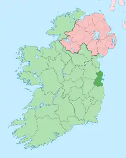 County Dublin in Ireland | |
| Counties | ||
| Other regions | ||
| Civil sub-divisions | ||
| Baronies of Dublin | ||