Green Sergeant's Covered Bridge
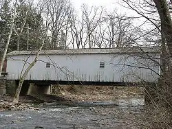
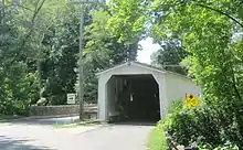
Green Sergeant's Covered Bridge is a wooden covered bridge over the Wickecheoke Creek near the border between the Hunterdon Plateau and Amwell Valley located in Delaware Township, Hunterdon County, New Jersey, United States. As the last historic covered bridge in the state of New Jersey, it is listed on the National Register of Historic Places (the Scarborough Bridge in Cherry Hill is the only other covered bridge in New Jersey). The bridge was first constructed in 1872, but after being damaged in 1960, it was dismantled and replaced with a modern bridge.[3] In 1961, due to public outcry, the bridge was rebuilt from the original materials.[3][4]
Green Sergeants Covered Bridge | |
 Green Sergeant's Covered Bridge | |
   | |
| Nearest city | Stockton, New Jersey |
|---|---|
| Coordinates | 40°26′39″N 74°57′59″W |
| Built | 1872 |
| Architect | Charles Ogden Holcombe |
| Part of | Covered Bridge Historic District (ID99000269]]) |
| NRHP reference No. | 74001165[1] |
| NJRHP No. | 1582[2] |
| Significant dates | |
| Added to NRHP | November 19, 1974 |
| Designated CP | March 5, 1999 |
| Designated NJRHP | July 1, 1974 |
The bridge has been damaged numerous times over the course of its history by vehicles striking the bridge structure, most recently in 2013 when a truck damaged the support beams of the bridge.[5]
It is a contributing structure in the Covered Bridge Historic District.
See also
References
- "National Register Information System". National Register of Historic Places. National Park Service. January 23, 2007.
- "New Jersey and National Registers of Historic Places - Hunterdon County" (PDF). New Jersey Department of Environmental Protection - Historic Preservation Office. April 1, 2010. p. 12. Archived from the original (PDF) on October 17, 2006. Retrieved October 15, 2010.
- Green Sergeant's Covered Bridge Association, onsite descriptions
- Frassinelli, Mike (April 25, 2011). "Only N.J. covered bridge harkens back to bygone era". The Star-Ledger. Retrieved August 18, 2014.
- Wright, Terry (February 26, 2013). "Truck hits New Jersey's last historic covered bridge. Again". Hunterdon County Democrat. Retrieved August 18, 2014.
External links
 Media related to Green Sergeant's Covered Bridge at Wikimedia Commons
| Topics | |
|---|---|
| Lists by state |
|
| Lists by insular areas | |
| Lists by associated state | |
| Other areas | |
| Related | |
| |