Gunung Mas Regency
Gunung Mas Regency (Indonesian: Kabupaten Gunung Mas) is one of the thirteen regencies which comprise the Central Kalimantan Province on the island of Kalimantan (Borneo), Indonesia. The town of Kuala Kurun is the capital of Gunung Mas Regency. The population of Gunung Mas Regency was 96,900 at the 2010 Census (an increase from 74,823 at the previous Census in 2000); the latest official estimate (as at January 2014) is 103,855. Gunung Mas Regency was formed in 2002.
Gunung Mas Regency
Kabupaten Gunung Mas | |
|---|---|
 Coat of arms | |
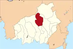 Location within Central Kalimantan | |
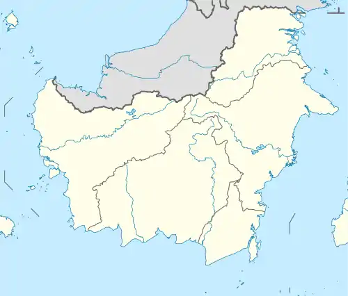 Gunung Mas Regency Location in Kalimantan and Indonesia  Gunung Mas Regency Gunung Mas Regency (Indonesia) | |
| Coordinates: 0.9500°S 113.5000°E | |
| Country | Indonesia |
| Region | Kalimantan |
| Province | Central Kalimantan |
| Capital | Kuala Kurun |
| Government | |
| • Regent | Arton S. Dohong |
| • Vice Regent | Rony Karlos |
| Area | |
| • Total | 4,172 sq mi (10,805 km2) |
| Population (2014) | |
| • Total | 103,855 |
| • Density | 25/sq mi (9.6/km2) |
| Time zone | UTC+7 (IWST) |
| Area code | (+62) 537 |
| Website | gunungmaskab |
Administrative districts
The regency comprises eleven districts, listed below withy their populations at the 2010 Census:[1]
- Damang Batu (3,638)
- Kahayan Hulu Utara (7,421)
- Kurun (21,825)
- Manuhing (7,288)
- Manuhing Raya (4,965)
- Mihing Raya (4,833)
- Miri Manasa (3,642)
- Rungan (14,061)
- Rungan Hulu (6,526)
- Sepang (6,112)
- Tewah (16,679)
- Total Regency (96,990)
Demographics
Religion as of the Indonesia 2010 census:[2]
- Protestant 62.8%
- Muslim 19.0%
- Roman Catholic 1.3%
- Buddhist 0.0%
- Hindu 0.0%
- Confucian 0.0%
- Other 16.8%
- Not stated or not asked 0.0%
Climate
Kuala Kurun, the seat of the regency has a tropical rainforest climate (Af) with heavy to very heavy rainfall year-round.
| Climate data for Kuala Kurun | |||||||||||||
|---|---|---|---|---|---|---|---|---|---|---|---|---|---|
| Month | Jan | Feb | Mar | Apr | May | Jun | Jul | Aug | Sep | Oct | Nov | Dec | Year |
| Average high °C (°F) | 29.1 (84.4) |
29.6 (85.3) |
30.1 (86.2) |
30.4 (86.7) |
30.5 (86.9) |
30.2 (86.4) |
30.4 (86.7) |
30.7 (87.3) |
30.8 (87.4) |
30.7 (87.3) |
30.1 (86.2) |
29.7 (85.5) |
30.2 (86.4) |
| Daily mean °C (°F) | 25.4 (77.7) |
25.8 (78.4) |
26.2 (79.2) |
26.4 (79.5) |
26.5 (79.7) |
26.1 (79.0) |
26.1 (79.0) |
26.4 (79.5) |
26.5 (79.7) |
26.4 (79.5) |
26.1 (79.0) |
25.9 (78.6) |
26.2 (79.1) |
| Average low °C (°F) | 21.8 (71.2) |
22.0 (71.6) |
22.3 (72.1) |
22.4 (72.3) |
22.6 (72.7) |
22.1 (71.8) |
21.9 (71.4) |
22.1 (71.8) |
22.2 (72.0) |
22.1 (71.8) |
22.1 (71.8) |
22.1 (71.8) |
22.1 (71.9) |
| Average rainfall mm (inches) | 335 (13.2) |
275 (10.8) |
356 (14.0) |
351 (13.8) |
350 (13.8) |
224 (8.8) |
216 (8.5) |
222 (8.7) |
268 (10.6) |
268 (10.6) |
335 (13.2) |
358 (14.1) |
3,558 (140.1) |
| Source: Climate-Data.org[3] | |||||||||||||
External links
References
- Biro Pusat Statistik, Jakarta, 2011.
- "Climate: Kuala Kurun". Climate-Data.org. Retrieved 24 November 2020.
This article is issued from Wikipedia. The text is licensed under Creative Commons - Attribution - Sharealike. Additional terms may apply for the media files.
