Kapuas Regency
Kapuas Regency (Indonesian: Kabupaten Kapuas) is one of the thirteen regencies which divide the island of Kalimantan, Central Kalimantan Province, Indonesia. Its population in 2010 was 329,646; in 2017, the population was 353,844.[1] and its capital is Kuala Kapuas. In 2002, Pulang Pisau and Gunung Mas Regencies were carved out of Kapuas Regency's then 25 districts.
Kapuas Regency
Kabupaten Kapuas | |
|---|---|
 Coat of arms | |
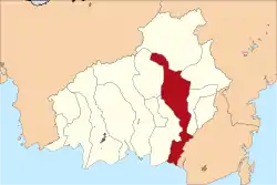 Location within Central Kalimantan | |
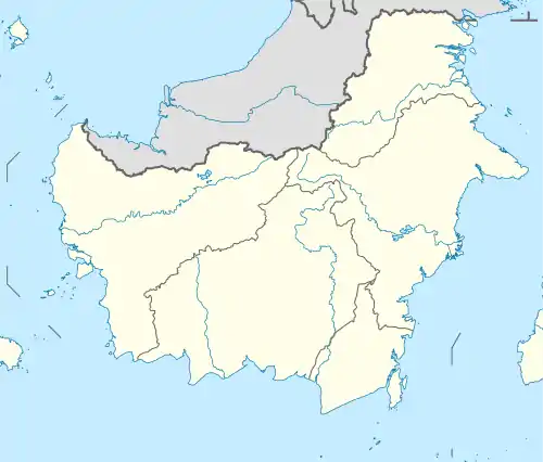 Kapuas Regency Location in Kalimantan and Indonesia  Kapuas Regency Kapuas Regency (Indonesia) | |
| Coordinates: 3°00′00″S 114°22′48″E | |
| Country | Indonesia |
| Region | Kalimantan |
| Province | Central Kalimantan |
| Capital | Kuala Kapuas |
| Government | |
| • Regent | Ben Brahim S. Bahat |
| • Vice Regent | Muhajirin |
| Area | |
| • Total | 5,791 sq mi (14,999 km2) |
| Population (2017)[1] | |
| • Total | 353,844 |
| Time zone | UTC+7 (IWST) |
| Area code | (+62) 513 |
| Website | kapuaskab |
Administrative Districts
Kapuas Regency consists of seventeen districts (kecamatan), tabulated below with their populations at the 2010 Census:[2]
|
|
|
Geography
The total area of Kapuas Regency is 14,999 square km (9.77% of the area of Central Kalimantan Province), delineated into ebbtide and non-ebbtide areas.[3] It adjoins Gunung Mas Regency, the Java Sea, Barito Selatan Regency and Kalimantan Selatan Province (Barito Kuala Regency), and Pulang Pisau Regency, to the north, south, east and west, respectively.
The north is marked by hills and mountains up to 500 metres above sea level, while the south is coastal and marshy, ebb-tidal and vulnerable to flooding. Rivers in Kapuas Regency are the Kapuas and Kapuas Murung, 600 and 66.38 km in length, respectively. There are four canals: Anjir Serapat (28 km in length;) and Anjir Tamban (25 km), each connecting Kuala Kapuas with Banjarmasin, running through Kalimantan Tengah (for 13-14 km) and Kalimantan Selatan (12-14 km); the Anjir Kalampan (14.5 km), connecting Mandomai, the capital of Kapuas Barat district, with Pulang Pisau Regency; and the Anjir Basarang (24 km), connecting Kuala Kapuas with Pulang Pisau.
Climate
Kuala Kapuas, the seat of the regency has a tropical rainforest climate (Af) with heavy rainfall in all months except July and August.
| Climate data for Kuala Kapuas | |||||||||||||
|---|---|---|---|---|---|---|---|---|---|---|---|---|---|
| Month | Jan | Feb | Mar | Apr | May | Jun | Jul | Aug | Sep | Oct | Nov | Dec | Year |
| Average high °C (°F) | 29.2 (84.6) |
30.0 (86.0) |
30.4 (86.7) |
31.0 (87.8) |
31.1 (88.0) |
30.9 (87.6) |
31.4 (88.5) |
32.1 (89.8) |
32.4 (90.3) |
32.0 (89.6) |
31.0 (87.8) |
30.2 (86.4) |
31.0 (87.8) |
| Daily mean °C (°F) | 25.6 (78.1) |
26.3 (79.3) |
26.6 (79.9) |
26.9 (80.4) |
27.0 (80.6) |
26.6 (79.9) |
26.8 (80.2) |
27.2 (81.0) |
27.4 (81.3) |
27.2 (81.0) |
26.7 (80.1) |
26.5 (79.7) |
26.7 (80.1) |
| Average low °C (°F) | 22.1 (71.8) |
22.6 (72.7) |
22.8 (73.0) |
22.9 (73.2) |
22.9 (73.2) |
22.3 (72.1) |
22.2 (72.0) |
22.3 (72.1) |
22.5 (72.5) |
22.4 (72.3) |
22.5 (72.5) |
22.8 (73.0) |
22.5 (72.5) |
| Average rainfall mm (inches) | 301 (11.9) |
321 (12.6) |
280 (11.0) |
242 (9.5) |
215 (8.5) |
132 (5.2) |
103 (4.1) |
116 (4.6) |
137 (5.4) |
140 (5.5) |
222 (8.7) |
287 (11.3) |
2,496 (98.3) |
| Source: Climate-Data.org[4] | |||||||||||||
Administration
Kapuas Regency controls seventeen districts, including 204 villages/wards (190 villages and 14 wards). These were categorised as 44 traditional (swadaya), 61 transitional (swakarya) and 59 development (swasembada) villages, 6 isolated villages/wards (2.94 percent) and 52 poor villages/wards (25.49 percent). In 2009, there were 190 village heads, 160 village secretaries, 950 village staff, 14 ward heads and 14 ward secretaries.
Population
The 2010 census recorded 329,646 people, including 167,937 males (50.98%) and 161,503 females (49.02%). The population density was 21.96 people/km2, ranging from a high of 507.43 in Selat to only 4.05 people/km2 in Mandau Talawang.
Demographics
Religion as of the Badan Pusat Statistic 2018:[1]
- Muslim 77.71%
- Protestant 12.15%
- Hindu 9.35%
- Roman Catholic 0.77%
- Buddhist 0.01%
- Confucian 0.00%
Social
Education is a development sector given priority by government (1945 Constitution mandate, as stated in article no 31 point 2), with an ultimate aim of improving the quality of human resources in Indonesia. There were 147 kindergartens in the regency, with 390 teachers and 4,181 students in 2009. In 2010, there were 390 Primary schools (including private schools), with 2,736 teachers and 40,714 students, yielding student:teacher ratio of about 14.88. There were 86 Junior High schools (state and private), with 1,085 teachers, 9,667 students and 465 classrooms; 25 Senior High schools (state and private), with 636 teachers and 5,886 students.
The region had only 38 doctors in 2010, resulting in a service ratio of 8,669.
References
- "Kapuas Regency in Figures 2018". BPS Kapuas Regency. Retrieved 13 September 2018.
- Biro Pusat Statistik, Jakarta, 2011.
- Kuala Kapuas
- "Climate: Kuala Kapuas". Climate-Data.org. Retrieved 24 November 2020.