Hà Tĩnh Province
Hà Tĩnh (Vietnamese: [hâː tǐŋ̟ˀ] (![]() listen)) is a province on the North Central Coast of Vietnam. Together with neighbouring Nghệ An Province the two provinces are together called "Nghệ Tĩnh", and the locals are known for speaking Vietnamese with a very noticeable accent.[2][3]
listen)) is a province on the North Central Coast of Vietnam. Together with neighbouring Nghệ An Province the two provinces are together called "Nghệ Tĩnh", and the locals are known for speaking Vietnamese with a very noticeable accent.[2][3]
Hà Tĩnh Province
Tỉnh Hà Tĩnh | |
|---|---|
 | |
 Seal | |
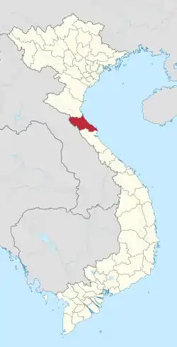 Location of Hà Tĩnh within Vietnam | |
| Coordinates: 18°20′N 105°54′E | |
| Country | |
| Region | North Central Coast |
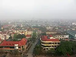
| Capital | Hà Tĩnh |
| Government | |
| • People's Council Chair | Đặng Quốc Khánh |
| • People's Committee Chair | Lê Đình Sơn |
| Area | |
| • Total | 5,997.8 km2 (2,315.8 sq mi) |
| Population (2019)[1] | |
| • Total | 1,478,261 |
| • Density | 250/km2 (640/sq mi) |
| Demographics | |
| • Ethnicities | Vietnamese, Thai, Chứt, Mường |
| Time zone | UTC+7 (ICT) |
| Area codes | 239 |
| ISO 3166 code | VN-23 |
| Website | www |
Geography
Hà Tĩnh Province is located in the northern part of central Vietnam, about 340 km (211 miles) south of Hanoi, bordered by Nghệ An Province to the north, Quảng Bình Province to the south, Laos to the west, and the Eastern Sea to the east.
Climate
Vietnam's highest ever temperature, 43.4 degrees Celsius (110 Fahrenheit), was recorded in the province in 2019.[4]
Administrative divisions
Hà Tĩnh is subdivided into 13 district-level sub-divisions:
- 10 districts:
- 2 district-level towns:
- 1 provincial city:
- Hà Tĩnh (capital)
They are further subdivided into 12 commune-level towns (or townlets), 235 communes, and 15 wards.
Tourism and Notables
Hà Tĩnh has many touristic locations of historical and cultural interest. It is home to national figures such as Lê Hữu Trác, Nguyễn Du (the author of the epic poem Kim Vân Kiều), Nguyễn Công Trứ, Phan Đình Phùng, Trần Phú, Ngô Đức Kế, Nguyễn Phan Chánh, Hoàng Ngọc Phách, Xuân Diệu, Huy Cận, Hoàng Xuân Hãn, Nguyễn Khắc Viện, Lê Văn Thiêm, Điềm Phùng Thị and Nguyen Do. Notable scenic areas include La River, Vũ Môn Falls, Vũ Quang Garden, Kẻ Gỗ Lake, Sơn Kim hot springs, Đèo Ngang pass, Hương Tích Pagoda, and beaches in places such as Thiên Cầm, Ðèo Con, Xuân Thành and Chân Tiên. Most of them are along Highways 1A and 8.
Transport
Hà Tĩnh has 130 km (82 miles) of Highway 1A stretching from Bến Thủy Bridge (Vinh City) to Đèo Ngang Pass linking Hà Tĩnh and Quảng Bình. The Ho Chi Minh Route is the second most important route of the province. Hà Tĩnh also contains Road 8 which runs from Hồng Lĩnh town to Laos and the Viet-Lao highway from Vũng Áng Harbour (Kỳ Anh District) to Laos. In 2007, a railway link to Laos was proposed from Hà Tĩnh province.
Economy
Hà Tĩnh is among the poorest provinces of Vietnam with a GDP in 2008 of US$420 per capita. The poverty can be attributed to the harsh natural conditions with severe cold in winter and extreme heat in summer, floods and storms every autumn and unfavorable soil and natural resources. A badly-operated district and provincial government is also a hurdle to prosperity.
Agriculture, forestry and fishery takes up 35.5 percent of total GDP and the province's GDP accounts for 0.7 percent of Vietnam's GDP. Hà Tĩnh has taken slow steps in economic reforms though better signs in recent times are incentive. Vũng Áng harbour with some plants, factories and a thermal power station is becoming the most active economic hub. Vietnam Steel operates an iron mine in Thạch Khê District,[5] with reserves of 544 million tonnes of iron, which is one of the largest mines in southeast Asia.[6]
A US$10 billion iron and steel plant was built in Vũng Áng in the 2010s (see Formosa Ha Tinh Steel Corporation). The steel plant is part of an industrial park, which is estimated to cost more than US$20 billion. When finished in 2020, the industrial park will have a port, a 2,100-MW power plant and a steel plant with six blast furnaces.[7] In 2016, the Formosa Steel plant released untreated waste water with heavy metals and other toxins into the nearby sea, which caused the 2016 Vietnam marine life disaster.[8]
History
In Sino-Vietnamese characters, the province's name is written as 河靜, meaning "quiet river". Beginning in 1930 Hà Tĩnh, along with Nghệ An and Quảng Ngãi, was one of the early grounds for the Vietnamese rural Soviet movement and protests.[9][10]
References
- Statistical Handbook of Vietnam 2014 Archived July 6, 2015, at the Wayback Machine, General Statistics Office Of Vietnam
- Thê ́Anh Nguyêñ, Alain Forest Guerre et paix en Asie du Sud-Est Page 110 1998 " ... the regional way of speaking in the southern part of Thanh Nghệ, the so-called Nghệ Tĩnh (Nghệ An and Hà Tĩnh) dialect, ..."
- Jonathan D. London Education in Vietnam 2011 Page 186 "A teacher from Hà Tĩnh Province acknowledged this issue, quipping that his distinctive and “heavy” Hà Tĩnh accent would be tough even for most Việt teachers, let alone students."
- "To beat the heat, Vietnam rice farmers resort to planting at night". VNExpress International. Reuters. 26 June 2020. Retrieved 7 July 2020.
- Geological Survey (U.S.), Minerals Yearbook: Area Reports: International 2008: Asia and the Pacific, pp. 22-12, 26-9.
- http://en.vietnamplus.vn/Home/Vung-Ang-economic-zone-grows-into-national-industrial-centre/20137/36939.vnplus
- https://www.reuters.com/article/2014/05/15/us-vietnam-china-riots-casualties-idUSBREA4E03Y20140515
- Steve Mullman (30 June 2016). "A Taiwanese Steel Plant Caused Vietnam's Mass Fish Deaths the Government Says". Quartz. Retrieved 8 July 2016.
- Patricia M. Pelley Postcolonial Vietnam: New Histories of the National Past 2002 Page 196 "In September 1930, the first Vietnamese soviet (in the village of vi:Võ Liệt) was formed, and soon it encompassed the three provinces of Nghệ An, Hà Tĩnh, and Quảng Ngãi. By this point, a number of Vietnamese students were already attending ..."
- Nguyen Công LuanNationalist in the Viet Nam Wars: Memoirs of a Victim Turned Soldier 2011 "... "Soviet" style that led farmers from several villages in Nghệ An and Hà Tĩnh provinces to stage mass protests for months after May 1930"
External links
- Hà Tĩnh province People's Committee
- Poverty alleviation in Hà Tĩnh Province, Vietnam: A public archive of development project documents
| Wikimedia Commons has media related to Ha Tinh. |
Places adjacent to Hà Tĩnh Province | ||||||||||
|---|---|---|---|---|---|---|---|---|---|---|
| ||||||||||