Kiên Giang Province
Kiên Giang (![]() listen) is a province of Vietnam, located in the Mekong Delta region of southern Vietnam. It is known for fishing and rice farming. The provincial capital is Rạch Giá, 155 mi (249 km) from Ho Chi Minh City. Kiên Giang's area is about 6,299 km² and its population is about 1,634,043, of which 22 percent live in urban areas.
listen) is a province of Vietnam, located in the Mekong Delta region of southern Vietnam. It is known for fishing and rice farming. The provincial capital is Rạch Giá, 155 mi (249 km) from Ho Chi Minh City. Kiên Giang's area is about 6,299 km² and its population is about 1,634,043, of which 22 percent live in urban areas.
Kiên Giang Province
Tỉnh Kiên Giang | |
|---|---|
 | |
Seal | |
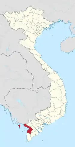 Location of Kiên Giang within Vietnam | |
| Coordinates: 10°0′N 105°10′E | |
| Country | |
| Region | Mekong Delta |
| Capital | Rạch Giá |
| Government | |
| • People's Council Chair | Đặng Tuyết Em |
| • People's Committee Chair | Phạm Vũ Hồng |
| Area | |
| • Total | 6,299 km2 (2,432 sq mi) |
| Population (2019) | |
| • Total | 2,109,099 |
| • Density | 330/km2 (870/sq mi) |
| Demographics | |
| • Ethnicities | Vietnamese, others |
| Time zone | UTC+7 (ICT) |
| Area codes | 297 |
| ISO 3166 code | VN-47 |
| Website | www |
Kiên Giang is bordered with An Giang Province in the northeast, Cần Thơ and Hậu Giang provinces in the east, Bạc Liêu Province in the southeast and Cà Mau Province in the south, and Kampot Province of Cambodia (with the 33 mi (53 km) border) in the west, and the Gulf of Thailand in the southwest (with the 124 mi (200 km) coast).
According to survey results on April 1, 2009, Kiên Giang province's population is 1,683,149 people.
History
In 1774, Lord Nguyen Phuc Dang Khoat divided into 12 in the palace, but still leave the town of Hà Tiên, Mac Thien Tich style as Admiral rule.
By the reign of Minh Mạng, in 1832, Hà Tiên had become one of the six provinces of the south.
In 1876, Southern France divided into four big administrative regions, each region divided into smaller administrative sub-district or county take action (administratif arrondissement), Hà Tiên, the former being divided into two particle parameters are Hà Tiên and Rạch Giá. From January 1, 1900 two-particle parameters of Hà Tiên and Rạch Giá became provinces of Hà Tiên and Rạch Giá.
Hà Tiên and Rạch Giá were later merged into Kiên Giang. Kiên Giang had seven districts at the time: Hà Tiên, Kiên An, Kiên Bình, Kiên Lương, Kiên Tân, Kiên Thành and Phú Quốc.
Geography
General
- Coordinates: 9°23'50" N to 10°32'30" N, 104°40' E to 105°32'40" E.
- Area: 6,299 km², 4,119.74 km² of agricultural land (66% natural area), private land for rice accounts for 3,170.19 km² (77% of agricultural land). Forests cover 1,200.27 km² (19% of the area). The province also contains 500.00 km² of unused land.
- The average elevation of the province is 0.39 metres (1 ft 3 in) above sea level, making it vulnerable to sea level rise.[1]
Climate
- Average annual rainfall: 1980mm;
- Average temperature: 27.3 °C (80.6°F);
- The dry season occurs for approximately 3 months and the rest of the year is mostly the wet season;
- Dry season: from 7 to 8 hours/day.
- Rainy Season: from 4 to 6 hours/day.
- Average relative humidity: 80 to 83%.
Administrative divisions
Kiên Giang is subdivided into 13 district-level sub-divisions and 2 cities:
- 12 districts:
- 3 cities:
- Phú Quốc Island
- Hà Tiên
- Rạch Giá (capital)
They are further subdivided into 12 commune-level towns (or townships), 118 communes, and 15 wards.
References
- Minderhoud, P. S. J.; Coumou, L.; Erkens, G.; Middelkoop, H.; Stouthamer, E. (2019). "Mekong delta much lower than previously assumed in sea-level rise impact assessments". Nature Communications. 10 (1): 3847. doi:10.1038/s41467-019-11602-1. ISSN 2041-1723.
External links
![]() Media related to Kien Giang at Wikimedia Commons
Media related to Kien Giang at Wikimedia Commons
- Official website
- Official website (in Vietnamese)
Places adjacent to Kiên Giang Province | |
|---|---|