Haymarket station (MBTA)
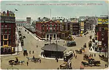
Haymarket is a subway station in Boston, Massachusetts. It serves the MBTA's Green and Orange lines, and is located at the corner of Congress and New Sudbury streets in Downtown Boston. Haymarket allows transfers between the Orange and Green lines, as does North Station one stop to the north. Haymarket was named for Haymarket Square, which has served as a produce market since around 1830.
Haymarket | ||||||||||||||||||||||||||||
|---|---|---|---|---|---|---|---|---|---|---|---|---|---|---|---|---|---|---|---|---|---|---|---|---|---|---|---|---|
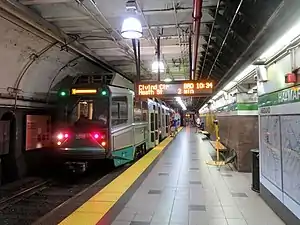 A southbound Green Line train at Haymarket station in 2019 | ||||||||||||||||||||||||||||
| Location | Congress Avenue at New Sudbury Street Boston, Massachusetts | |||||||||||||||||||||||||||
| Coordinates | 42.3633°N 71.0582°W | |||||||||||||||||||||||||||
| Line(s) | Tremont Street subway Washington Street Tunnel | |||||||||||||||||||||||||||
| Platforms | 2 side platforms (Orange Line) 1 island platform (Green Line) | |||||||||||||||||||||||||||
| Tracks | 4 (2 for each line) | |||||||||||||||||||||||||||
| Connections | ||||||||||||||||||||||||||||
| Construction | ||||||||||||||||||||||||||||
| Disabled access | Yes | |||||||||||||||||||||||||||
| History | ||||||||||||||||||||||||||||
| Opened | September 3, 1898 (Green Line) November 30, 1908 (Orange Line) | |||||||||||||||||||||||||||
| Rebuilt | May 10, 1971 (Green Line); 2000–2003[1] | |||||||||||||||||||||||||||
| Previous names | Friend and Union (Orange Line) | |||||||||||||||||||||||||||
| Passengers | ||||||||||||||||||||||||||||
| FY2019 | 10,597 (weekday average boardings)[2] | |||||||||||||||||||||||||||
| Services | ||||||||||||||||||||||||||||
| ||||||||||||||||||||||||||||
| ||||||||||||||||||||||||||||
| ||||||||||||||||||||||||||||
Unusually, the two subway lines that converge at Haymarket are not stacked vertically underground, but instead are parallel at approximately the same level. The Orange Line access consists of two side platforms to serve the line's two tracks, while the Green Line is served by a single island platform which is divided mostly in half by a wall. The station is fully accessible.
History
Tremont Street subway
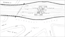
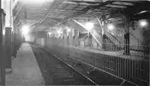
The Tremont Street subway (future Green Line), including Haymarket, was built starting in 1894 and opened on September 3, 1898. The original trolley station was much more spacious than the current station, and consisted of four tracks with a pair of island platforms. The inner pair of tracks served cars from the northern suburbs which turned at Brattle Loop at Scollay Square (now Government Center) station, while the outer tracks served streetcars that ran through the entire Tremont Street subway to the Public Gardens portal and Pleasant Street portal. All cars entered the subway through the Canal Street incline just north of Haymarket.
Main Line Elevated
On June 10, 1901, the Boston Elevated Railway's Main Line (future Orange Line) was opened from Sullivan Square to Dudley Square. The Tremont Street subway was retrofitted to allow operation of the Main Line elevated cars. Main Line trains from the Charlestown Elevated entered the tunnel through the outer tracks of the Canal Street portal and exited through the Pleasant Street portal to the Washington Street Elevated.[3] Elevated cars ran on the outer tracks at Haymarket, served by temporary high platforms; streetcars continued to use the inner tracks, which connected to a turnback loop at Adams Square station.
On November 30, 1908, a new Washington Street Tunnel opened for use by Main Line trains, and the whole Tremont Street subway was returned to streetcar use. The Washington Street Tunnel ran separately from the Tremont Street subway; however, because both tunnels used the newly expanded Canal Street incline, the Main Line platforms at Haymarket Square were immediately adjacent to the Tremont Street subway. Like the other Washington Street Tunnel stations, the two Main Line platforms were named after nearby streets. The northbound platform was Union and the southbound platform Friend – collectively called, Union–Friend.[3]
The track configuration at Haymarket after 1908 was similar to the original 1898 setup – the outer tracks served streetcars running through the subway, while the center tracks served cars turning at Brattle Loop at Scollay Square. The last (route #93) streetcars to use the inner tracks ran on July 2, 1949, although a North Station to Scollay Square shuttle ran until September 1952.[3] After that, only emergency and special service cars used the inner tracks.
MBTA era

On October 28, 1963, the tunnel between Haymarket and the newly renamed Government Center station was realigned, and Adams Square station was closed. The outer tracks at Haymarket now connected directly to the through tracks at Government Center, while the center tracks connected to Brattle Loop. On January 26, 1967, Union and Friend platforms were officially renamed Haymarket.[3]
On May 10, 1971, the MBTA opened a new Green Line platform at Haymarket, located south (inbound) of the 1898-built station. The new island platform occupies the space of the former center tracks, which were reconnected to the through tracks just south of the new platform.[3] The original 1898 platforms are still visible in the tunnel from Green Line cars traveling just north of the new platforms. The empty space is now used for electrical equipment and occasional storage. A new entrance and busway under the Government Center Garage opened on December 20, 1971.[4] In August 1975, the MBTA released plans to modernize four downtown stations, including the Orange Line platforms at Haymarket.[4]
The Haymarket North Extension opened on April 7, 1975, replacing the Charlestown Elevated. North of Haymarket, the Orange Line tracks were redirected from the Canal Street incline into a new tunnel to North Station, and then under the Charles River.[3] In June 2004, the Green Line was similarly rerouted, with the Canal Street incline closing entirely in favor of a tunnel to a newly rebuilt "superstation" at North Station.[3] That spacious new facility allows convenient cross-platform transfers between the inbound Green and Orange Lines, as well as full outbound connections, lessening the importance of Haymarket as a rail transfer station.[5] However, Haymarket station remains a major bus transfer station, served by many routes.[5]
A 2000–01 renovation, part of the Parcel 7 construction, added elevators to all levels of Haymarket.[1] This made the Orange Line accessible at the station.[6] A $15 million project to build raised platforms at Park Street and Haymarket began in 2001 and was completed by 2003.[7][8][9] On June 24, 2019, the MBTA Board awarded a $29.7 million, 16-month contract for full cleaning, wayfinding signage replacement, and other improvements at North Station, Haymarket, State, and Downtown Crossing stations.[10] Much of the cosmetic work at Haymarket, including painting and floor repairs, was completed over the weekend of August 30–September 1, 2019.[11] As of May 2020, the work is expected to be complete by the end of 2020.[12]
Part of the Bulfinch Crossing development will be built over the busway in the early 2020s; the project will include a modernization of the Green Line entrance and the busway.[13][14] A temporary closure of the station during construction was originally considered; the developer later agreed to keep the station open, though temporary closures of the north headhouse may be needed.[15][16] As of February 2020, the section of the garage above the station is planned to be demolished in December 2020.[15]
Station layout
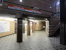
Because the Washington Street Tunnel was built to replace the Tremont Street subway for Main Line Elevated use – and to share the Canal Street incline – the Green Line and Orange Line are parallel and approximately the same depth at Haymarket. The Green Line, to the west of the Orange Line, has two tracks serving an island platform divided in half by a wall. The Orange Line has two tracks serving two side platforms. A sub-passage at the north end of the platforms allows transfer between the two lines.
The two lines have separate primary entrances, although the sub-passage allows both lines to be reached from either entrance. The Green Line entrance is located north of Sudbury Street, under the east end of the Government Center Garage. It is adjacent to a two-lane busway off Surface Road, which can be reached by buses using the Sumner and Callahan tunnels or North Washington Street. The Green Line fare lobby is level with the platform. The Orange Line entrance is inside the Boston Public Market building south of Sudbury Street. A mezzanine level is between the street-level fare lobby and the platforms.
Two elevators connect the Orange Line entrance to the two platforms, and another pair connect the platforms to the sub-passage. An elevator connects the Green Line entrance to the fare lobby, and the Green Line platform to the sub-passage.
Bus connections
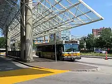

Haymarket is a major bus transfer station and features a two-lane busway off Surface Road. Services from Haymarket include several local routes to Charlestown and Chelsea, as well as express buses to northern suburbs and the North Shore.
- 4: North Station–Tide Street
- 92: Sullivan Square station–Downtown via Main Street
- 93: Sullivan Square Station–Downtown via Bunker Hill Street
- 111: Woodlawn–Haymarket station
- 325: Elm Street, Medford–Haymarket
- 326: West Medford–Haymarket
- 352: Burlington–State Street, Boston
- 354: Woburn–Downtown Boston
- 426: Central Square, Lynn–Haymarket station
- 428: Oaklandvale–Haymarket station
- 434: Main Street, Peabody–Haymarket station
- 450: Salem Depot–Haymarket station
Routes 4, 92, 93, 352, and 354 do not use the busway and instead stop on surrounding surface streets.
Haymarket is also the terminus for four bus routes each with a single early-morning run. These routes were created in September 1960 for fare collectors, but in September 1999 they were added to public timetables as well.[3]
- 191: Mattapan station–Haymarket station
- 192: Cleary Square–Haymarket station
- 193: Watertown Yard–Haymarket station
- 194: Clarendon Hill–Haymarket station
References
- Tran Systems and Planners Collaborative (August 24, 2007). "Evaluation of MBTA Paratransit and Accessible Fixed Route Transit Services: Final Report" (PDF). Massachusetts Bay Transportation Authority.
- "A Guide to Ridership Data". MassDOT/MBTA Office of Performance Management and Innovation. June 22, 2020. p. 6.
- Belcher, Jonathan. "Changes to Transit Service in the MBTA district" (PDF). NETransit.
- A Chronicle of the Boston Transit System. Massachusetts Bay Transportation Authority. 1981. pp. 8, 10 – via Internet Archive.
- Elder, Andrew; Fox, Jeremy C. (2013). Boston's Orange Line. Arcadia Publishing. p. 51. ISBN 9781467120470.
- "Subway Map" (PDF). Massachusetts Bay Transportation Authority. 2001. Archived from the original (PDF) on July 1, 2001.
- "U.S. Government Procurements". Commerce Business Daily. No. PSA-2843. May 8, 2001. p. 17 – via Google Books.
- "Planned Accessibility Projects – On Board the Green Line". Massachusetts Bay Transportation Authority. Archived from the original on August 10, 2004.
- Ridership & Service Statistics (9 ed.). Massachusetts Bay Transportation Authority. 2004. p. 2.19 – via Internet Archive.
- "MBTA Contract No. A01CN01: Wayfinding and Station Improvements – Four Stations (Downtown Crossing, State, Haymarket, and North Station)" (PDF). Massachusetts Bay Transportation Authority. June 24, 2019.
- "Labor Day Haymarket Brightening Work" (Press release). Massachusetts Bay Transportation Authority. September 4, 2019.
- Brelsford, Laura (May 26, 2020). "SWA Initiatives—May 2020" (PDF). p. 5.
- "Project of the Month: National Real Estate Advisors and HYM continue construction on 2.9 million s/f Bulfinch Crossing". New England Real Estate Journal. November 23, 2018.
- O'Brien, Thomas N. (Spring 2017). "Bulfinch Crossing The Next Phase of Urban Revitalization in Boston". Development Magazine.
- MacNeill, Arianna (February 10, 2020). "Haymarket station planned to remain open during garage demolition, construction". Boston Globe.
- "Work Program: Haymarket Station Redevelopment Analysis" (PDF). Boston Region Metropolitan Planning Organization. February 6, 2020.
External links
| Wikimedia Commons has media related to Haymarket station (MBTA). |
- MBTA – Haymarket
- Google Maps Street View: Congress Street headhouse, Surface Road headhouse