History of the administrative divisions of China (1912–49)
The history of the administrative divisions of China between 1912 and 1949 refers to the administrative divisions under the Republic of China government control.
Introduction
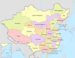
The Republic of China was founded in 1912. It used most of the same administrative divisions as the Qing Dynasty but divided Inner Mongolia into four provinces and set up several municipalities under the authority of the Executive Yuan. After the end of World War II in 1945, Manchuria was reincorporated into the Republic of China as nine provinces. Taiwan and the Pescadores were also acquired by the Republic of China and organized into Taiwan Province after Retrocession Day. By this time the top-level divisions consisted of 35 provinces, 12 Yuan-controlled municipalities, one special administrative region and two regions (Mongolia and Tibet).
After the central government's withdrawal from mainland China during the Chinese Civil War and subsequent relocation to Taiwan in 1949, the jurisdiction of the ROC was restricted to only Taiwan, the Pescadores, Hainan, and a few offshore islands of Fukien and Chekiang. Hainan fell to the Communist regime in May 1950 and Chekiang was also lost in 1955. The remaining area is called the "Free Area of the Republic of China" in the Constitution. In most ordinary legislation, the term "Taiwan Area" is used in place of the "Free Area", while Mainland China is referred to as the "Mainland Area."
Beiyang Government (1912–28)
 Provinces and areas of the Republic of China in 1912. |
 Map of the Republic of China in 1926 |
The Beiyang Government streamlined the system used in Qing Dynasty down to three levels:
The Beiyang Government set up four more provinces out of Inner Mongolia and the surrounding areas (Chahar, Jehol, Ningsia, Suiyuan) and two others out of parts of historical Tibet (Chuanbian (or Chwanpien, later Xikang/Sikang) out of Kham and Tsinghai out of Amdo; Ü-Tsang was the Dalai Lama's realm at this time and not part of any province), bringing the total number of provinces up to 28.
| Division name | Abbreviation | Capital name | Note | |||||
|---|---|---|---|---|---|---|---|---|
| Postal | Chinese | Pinyin | Chinese | Pinyin | Postal | Chinese | Pinyin | |
| Provinces (省 Shěng) | ||||||||
| Anhwei | 安徽 | Ānhuī | 皖 | Wǎn | Anking | 安慶 | Ānqìng | |
| Chekiang | 浙江 | Zhèjiāng | 浙 | Zhè | Hangchow | 杭州 | Hángzhōu | |
| Chihli | 直隸 | Zhílì | 直 | Zhí | Tientsin | 天津 | Tiānjīn | 1914 area around Peking (Beijing) split into Shuntien Prefecture |
| Fengtien | 奉天 | Fèngtiān | 奉 | Fèng | Mukden | 瀋陽 | Shěnyáng | |
| Fukien | 福建 | Fújiàn | 閩 | Mǐn | Foochow | 福州 | Fúzhōu | |
| Heilungkiang | 黑龍江 | Hēilóngjiāng | 黑 | Hēi | Tsitsihar | 齊齊哈爾 | Qíqíhār | 1914 Hulunbuir Region split, 1920 merged back. |
| Honan | 河南 | Hénán | 豫 | Yù | Kaifeng | 開封 | Kāifēng | |
| Hunan | 湖南 | Húnán | 湘 | Xiāng | Changsha | 長沙 | Chángshā | |
| Hupeh | 湖北 | Húběi | 鄂 | È | Wuchang | 武昌 | Wǔchāng | |
| Kansu | 甘肅 | Gānsù | 隴 | Lǒng | Lanchow | 蘭州 | Lánzhōu | |
| Kiangsi | 江西 | Jiāngxī | 贛 | Gàn | Nanchang | 南昌 | Nánchāng | |
| Kiangsu | 江蘇 | Jiāngsū | 蘇 | Sū | Nanking | 南京 | Nánjīng | 1912 area around Nanking (Nanjing) shortly split to a prefecture |
| Kirin | 吉林 | Jílín | 吉 | Jí | Kirin | 吉林 | Jílín | |
| Kwangsi | 廣西 | Guǎngxī | 桂 | Guì | Kweilin | 桂林 | Guìlín | |
| Kwangtung | 廣東 | Guǎngdōng | 粵 | Yuè | Canton | 廣州 | Guǎngzhōu | |
| Kweichow | 貴州 | Guìzhōu | 黔 | Qián | Kweiyang | 貴陽 | Guìyáng | |
| Shansi | 山西 | Shānxī | 晉 | Jìn | Taiyuan | 太原 | Tàiyuán | |
| Shantung | 山東 | Shāndōng | 魯 | Lǔ | Tsinan | 濟南 | Jǐnán | |
| Shensi | 陝西 | Shǎnxī | 陝 | Shǎn | Sian | 西安 | Xī'ān | |
| Sinkiang | 新疆 | Xīnjiāng | 新 | Xīn | Tihwa | 迪化 | Díhuà | Tihwa was renamed Ürümqi (烏魯木齊) after 1949 |
| Szechwan | 四川 | Sìchuān | 蜀 | Shǔ | Chengtu | 成都 | Chéngdū | |
| Yunnan | 雲南 | Yúnnán | 滇 | Diān | Kunming | 昆明 | Kūnmíng | |
| Areas (地方 Dìfāng) | ||||||||
| Capital | 京兆 | Jīngzhào | 京 | Jīng | About the place of modern Municipality of Beijing | |||
| Inner Mongolia | 內蒙古 | Nèiménggǔ | 內蒙 | Nèiméng | Inner Mongolia was divided into several Mongolian leagues and banners. There was no obvious capital. Split into Chahar, Jehol, Suiyuan in 1913–14. | |||
| Outer Mongolia | 外蒙古 | Wàiménggǔ | 外蒙 | Wàiméng | Khuree | 庫倫 | Kùlún | Khuree was renamed Ulaan Bator after the independence of Mongolia |
| Tibet | 西藏 | Xīzàng | 藏 | Zàng | Lhasa | 拉薩 | Lāsà | |
| Tsinghai | 青海 | Qīnghǎi | 青 | Qīng | Sining | 西寧 | Xïníng | |
| Regions (區域 Qūyù) | ||||||||
| Altay | 阿爾泰 | Ā'ěrtài | 阿爾泰 | Āěrtài | Altay | 承化寺 | Chénghuàsì | 1920 abolished → Sinkiang The Chinese name of the capital 承化寺 was changed to Ālètài (阿勒泰) after 1949. |
| Hulunbuir | 呼倫貝爾 | Hūlúnbèi'ěr | 呼倫貝爾 | Hūlúnbèi'ěr | Hailar | 海拉爾 | Hǎilā'ěr | 1915 created, 1920 abolished → Heilungkiang |
| Tarbaghatay | 塔爾巴哈臺 | Tǎ'ěrbāhātái | 塔城 | Tǎchéng | Tacheng | 塔城 | Tǎchéng | 1912 created, 1916 abolished → Sinkiang |
| Prefectures (府 Fǔ) | ||||||||
| Nanking | 南京 | Nánjīng | 寧 | Níng | January 1912 created, February 1912 abolished → Kiangsu | |||
| Shuntien | 順天 | Shùntiān | 京 | Jīng | May 1914 created from Chihli, renamed Capital Area in October | |||
| Special Administrative Regions (特別區 Tèbiéqū) | ||||||||
| Chahar | 察哈爾 | Cháhāěr | 察 | Chá | Changyuan | 張垣 | Zhāngyuán | 1914 created from Inner Mongolia Changyuan was renamed Zhangjiakou (張家口) after 1949. |
| Chwanpien | 川邊 | Chuānbiān | 川邊 | Chuānbiān | Kangting | 康定 | Kāngdìng | 1925 renamed to Sikang |
| Jehol | 熱河 | Rèhé | 熱 | Rè | Chengteh | 承德 | Chéngdé | 1914 created from Inner Mongolia |
| Sikang | 西康 | Xīkāng | 康 | Kāng | Kangting | 康定 | Kāngdìng | 1925 renamed from Chwanpien |
| Suiyuan | 綏遠 | Suīyuǎn | 綏 | Suī | Kweisui | 歸綏 | Guīsuī | 1913 created from Inner Mongolia Kweisui was renamed Hohhot (呼和浩特) after 1949 |
| Tungsheng | 東省 | Dōngshěng | 東省 | Dōngshěng | Harbin | 哈爾濱 | Hā'ěrbīn | Land along the Chinese Eastern Railway, spanned from Manzhouli through Harbin to Suifenhe. |
| Commercial Region (商埠 Shāngbù) | ||||||||
| Kiao-ao | 膠澳 | Jiāo'ào | 膠 | Jiāo | Tsingtao | 青島 | Qīngdǎo | Formerly Japanese and German concession. 1925 abolished → Shantung |
| Sunghu | 淞滬 | Sōnghù | 滬 | Hù | Shanghai | 上海 | Shànghǎi | Status in dispute. Division established by the Zhili clique leader Sun Chuanfang, was not recognized by the central government. |
Nationalist Government (1928–49)
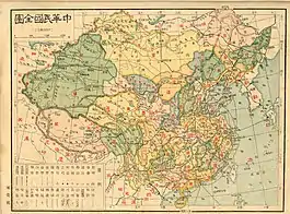
 Map of the Republic of China in 1936 |
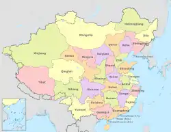
 Map of the Republic of China in 1946 |
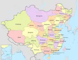
 Map of the Republic of China in 1949 |
The Nationalist Government also began setting up municipalities, cities directly administered by the central government. More levels began to be added below the county, townships for instance. Circuits were then abolished in 1928 as being superfluous. However, this reform was soon found to be unfeasible since the average province now had 50+ counties and some more than a hundred. As a result, some provinces were later subdivided into several prefectures.
- Provinces (省, shěng)
- Administrative superintendent district (行政督察區, xíngzhèng dūcháqū)
- Counties (縣, xiàn)
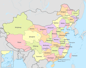
The creation of the puppet state Manchukuo by the Empire of Japan in the 1930s deprived China of 4 provinces in the northeast (Fengtien, Heilungkiang, Jehol, Kirin). After the defeat of Japan in 1945, Manchuria was reincorporated into China as 9 provinces and 3 municipalities. The Republic of China also annexed Taiwan and the Pescadores and organized into Taiwan Province. By this time there was a total of thirty-five provinces, twelve municipalities (院轄市, yuànxiáshì), one special administrative region (特別行政區, tèbié xíngzhèngqǖ), and two regions (地方, difāng) as first-level divisions under the Republic of China.
| Division name | Abbreviation | Capital name | Note | |||||
|---|---|---|---|---|---|---|---|---|
| Postal | Chinese | Pinyin | Chinese | Pinyin | Postal | Chinese | Pinyin | |
| Provinces (省 Shěng) | ||||||||
| Antung | 安東 | Āndōng | 安 | Ān | Tunghwa | 通化 | Tōnghuà | 1947 created from Manchukuo (originally part of Liaoning) |
| Anhwei | 安徽 | Ānhuī | 皖 | Wǎn | Hofei | 合肥 | Héféi | |
| Chahar | 察哈爾 | Cháhāěr | 察 | Chá | Kalgan | 張垣 | Zhāngyuán | 1928 reformed from a special administrative region Kalgan was renamed Zhangjiakou (張家口) after 1949. |
| Chekiang | 浙江 | Zhèjiāng | 浙 | Zhè | Hangchow | 杭州 | Hángzhōu | |
| Fukien | 福建 | Fújiàn | 閩 | Mǐn | Foochow | 福州 | Fúzhōu | |
| Heilungkiang | 黑龍江 | Hēilóngjiāng | 黑 | Hēi | Peian | 北安 | Běi'ān | 1945 recreated from Manchukuo |
| Hokiang | 合江 | Héjiāng | 合 | Hé | Chiamussu | 佳木斯 | Jiāmùsī | 1947 created from Manchukuo (originally part of Kirin) |
| Honan | 河南 | Hénán | 豫 | Yù | Kaifeng | 開封 | Kāifēng | |
| Hopeh | 河北 | Héběi | 冀 | Jì | Tsingyuan | 清苑 | Qīngyuàn | 1928 renamed from Chihli Tsingyuan was renamed to Baoding (保定) after 1949 |
| Hunan | 湖南 | Húnán | 湘 | Xiāng | Changsha | 長沙 | Chángshā | |
| Hupeh | 湖北 | Húběi | 鄂 | È | Wuchang | 武昌 | Wǔchāng | |
| Hsingan | 興安 | Xīng'ān | 興 | Xīng | Hailar | 海拉爾 | Hǎilā'ěr | 1947 created from Manchukuo (originally part of Heilungkiang) Hailar was renamed to Hulunbuir (呼倫貝爾) after 1949 |
| Jehol | 熱河 | Rèhé | 熱 | Rè | Chengteh | 承德 | Chéngdé | 1928 reformed from a special administrative region, 1945 recreated from Manchukuo |
| Kansu | 甘肅 | Gānsù | 隴 | Lǒng | Lanchow | 蘭州 | Lánzhōu | |
| Kiangsi | 江西 | Jiāngxī | 贛 | Gàn | Nanchang | 南昌 | Nánchāng | |
| Kiangsu | 江蘇 | Jiāngsū | 蘇 | Sū | Chinkiang | 鎮江 | Zhènjiāng | |
| Kirin | 吉林 | Jílín | 吉 | Jí | Kirin | 吉林 | Jílín | 1945 recreated from Manchukuo |
| Kwangsi | 廣西 | Guǎngxī | 桂 | Guì | Kweilin | 桂林 | Guìlín | |
| Kwangtung | 廣東 | Guǎngdōng | 粵 | Yuè | Canton | 廣州 | Guǎngzhōu | |
| Kweichow | 貴州 | Guìzhōu | 黔 | Qián | Kweiyang | 貴陽 | Guìyáng | |
| Liaoning | 遼寧 | Liáoníng | 遼 | Liáo | Mukden | 瀋陽 | Shěnyáng | 1929 renamed from Fengtien, 1945 recreated from Manchukuo |
| Liaopeh | 遼北 | Liáoběi | 洮 | Táo | Liaoyuan | 遼源 | Liáoyuán | 1947 created from Manchukuo (originally part of Liaoning) |
| Ningsia | 寧夏 | Níngxià | 寧 | Níng | Yinchwan | 銀川 | Yínchuān | 1928 created from Kansu |
| Nunkiang | 嫩江 | Nènjiāng | 嫩 | Nèn | Tsitsihar | 齊齊哈爾 | Qíqíhā'ěr | 1947 created from Manchukuo (originally part of Heilungkiang) |
| Shansi | 山西 | Shānxī | 晉 | Jìn | Taiyuan | 太原 | Tàiyuán | |
| Shantung | 山東 | Shāndōng | 魯 | Lǔ | Tsinan | 濟南 | Jǐnán | |
| Shensi | 陝西 | Shǎnxī | 陝 | Shǎn | Sian | 西安 | Xī'ān | |
| Sikang | 西康 | Xīkāng | 康 | Kāng | Kangting | 康定 | Kāngdìng | 1928 reformed from a special administrative region |
| Sinkiang | 新疆 | Xīnjiāng | 新 | Xīn | Tihwa | 迪化 | Díhuà | Tihwa was renamed Ürümqi (烏魯木齊) after 1949 |
| Suiyuan | 綏遠 | Suīyuǎn | 綏 | Suī | Kweisui | 歸綏 | Guīsuī | 1928 reformed from a special administrative region Kweisui was renamed Hohhot (呼和浩特) after 1949 |
| Sungkiang | 松江 | Sōngjiāng | 松 | Sōng | Mutankiang | 牡丹江 | Mǔdānjiāng | 1947 created from Manchukuo (originally part of Kirin) |
| Szechwan | 四川 | Sìchuān | 蜀 | Shǔ | Chengtu | 成都 | Chéngdū | |
| Taiwan | 臺灣 | Táiwān | 臺 | Tái | Taipei | 臺北 | Táiběi | 1945 annexed from Japan |
| Tsinghai | 青海 | Qīnghǎi | 青 | Qīng | Sining | 西寧 | Xīníng | 1928 reformed from an area |
| Yunnan | 雲南 | Yúnnán | 滇 | Diān | Kunming | 昆明 | Kūnmíng | |
| Special Administrative Regions (特別行政區 Tèbiéxíngzhèngqū) | ||||||||
| Hainan | 海南 | Hǎinán | 瓊 | Qióng | Haikow | 海口 | Hǎikǒu | 1931 Kiung-ai (瓊崖) was planned to create, 1949 created from Kwangtung |
| Tungsheng | 東省 | Dōngshěng | 東省 | Dōngshěng | Harbin | 哈爾濱 | Hā'ěrbīn | 1932 abolished by Manchukuo |
| Weihai | 威海 | Wēihāi | 威海 | Wēihāi | Weihai | 威海 | Wēihāi | 1930 acquired from the United Kingdom, 1945 abolished → Shantung |
| Areas (地方 Dìfāng) | ||||||||
| Mongolia | 蒙古 | Ménggǔ | 蒙 | Méng | Khuree | 庫倫 | Kùlún | Khuree was renamed Ulaan Bator after the independence of Mongolia |
| Tibet | 西藏 | Xīzàng | 藏 | Zàng | Lhasa | 拉薩 | Lāsà | |
| Special municipalities (直轄市 Zhíxiáshì) | ||||||||
| Canton | 廣州 | Guǎngzhōu | 穗 | Suì | Jan 1930 created from Kwangtung, Jun merged back. 1947 recreated | |||
| Chungking | 重慶 | Chóngqìng | 渝 | Yú | 1927 created from Szechwan | |||
| Dairen | 大連 | Dàlián | 連 | Lián | 1947 created from Manchukuo (originally part of Liaoning) | |||
| Hankow | 漢口 | Hànkǒu | 漢 | Hàn | 1927 created Wuhan from Hupeh, 1929 renamed to Hankow, 1931 merged back, 1947 recreated | |||
| Harbin | 哈爾濱 | Hā'ěrbīn | 哈 | Hā | 1947 created from Manchukuo (originally part of Heilungkiang) | |||
| Mukden | 瀋陽 | Shěnyáng | 瀋 | Shěn | 1947 created from Manchukuo (originally part of Liaoning) | |||
| Nanking | 南京 | Nánjīng | 京 | Jīng | 1927 created from Kiangsu | |||
| Peiping | 北平 | Běipíng | 平 | Píng | 1928 created from Hopeh, Jun 1930 merged back, Dec 1930 recreated. 1949 renamed back to Peking (北京) | |||
| Shanghai | 上海 | Shànghǎi | 滬 | Hù | 1927 reform Sunghu commercial region to a municipality, created from Kiangsu | |||
| Sian | 西安 | Xī'ān | 安 | Ān | 1933 planned to create Siking (西京), 1947 created from Shensi | |||
| Tientsin | 天津 | Tiānjīn | 津 | Jīn | 1928 created from Hopeh, 1930 merged back. 1935 recreated | |||
| Tsingtao | 青島 | Qīngdǎo | 青 | Qīng | 1929 created from Shantung. | |||
Administrative divisions published after 1949
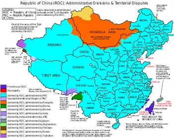 A map showing the official divisions and territories historically claimed by the Republic of China, along with their status as of 2005. |
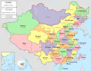 Map comparing political divisions as drawn by the Republic of China and the People's Republic of China. |
After the loss of the mainland to the Communist Party in the Chinese Civil War and its retreat to Taiwan in 1949, the Nationalist Party continued to regard the Republic of China as the internationally recognized sole legitimate government of China. The jurisdiction of the Republic was restricted to Taiwan, the Pescadores, and a few islands off Fujian, but the Republic of China has never retracted its claim to mainland China or Mongolia. Accordingly, the official first-order divisions of Republic of China remain the historical divisions of China immediately prior to the loss of mainland China and maps of China and the world published in Taiwan sometimes show provincial and national boundaries as they were in 1949, ignoring changes made by the Communist government and including Mongolia, northern Burma (northern Kachin state), and Tannu Uriankhai as part of the Republic. Maps and list of administrative divisions covering above places are currently published.
In 2005, the nominal political divisions of the Republic were 35 provinces, 1 special administrative region, 2 regions, 14 special municipalities (adding Taipei and Kaohsiung to the original list), 14 leagues, and 4 special banners. For second-order divisions, under provinces and special administrative regions, there are counties, province-controlled cities (56), bureaus (34) and management bureaus (7). Under provincial-level municipalities there are districts, and under leagues there are banners (127).
- Provinces (省, shěng) and Special municipalities (直轄市, zhíxiáshì)
- Counties (縣, xiàn) and Cities (市, shì)
| Changes made to Province-level divisions of the Republic of China between 1949 and 2005 | |||||||||||
|---|---|---|---|---|---|---|---|---|---|---|---|
| Name | Traditional Chinese | Pinyin | Abbreviation | Capital | Capital in Chinese | Notes | |||||
| Provinces | |||||||||||
| Fujian | 福建 | Fújiàn | 閩 mǐn | Jincheng Township | 金城鎮 | The capital of Fukien Province was moved to Xindian in 1956, and moved to Jincheng Township, Kinmen since 1996. The Fujian Provincial Government was de facto abolished in 2019. | |||||
| Taiwan | 臺灣 | Táiwān | 臺 tái | Zhongxing New Village | 中興新村 | The capital of Taiwan Province was moved to Zhongxing Village in Nantou County from Taipei in the 1960s. The government was de facto dissolved in 2018. | |||||
| Kiangsu | 江蘇 | Jiāngsū | 蘇 sū | Shengsi County | 嵊泗縣 | The government of Kiangsu Province was moved to Shengsi County in 1949. In 1950 the county was conquered by the PLA and the Kiangsu Provincial Government was abolished soon after. | |||||
| Chekiang | 浙江 | Zhèjiāng | 浙 zhè | Taiwan Province | 臺灣省 | The government of Chekiang Province in Ganlan Township of Dinghai County was abolished in 1950. In 1951, the provincial government was re-established on the Tachen Islands of Wenling County, later to be moved to Taiwan Province in 1953. After the loss of the Yijiangshan Islands during the Battle of Yijiangshan Islands in 1955, the provincial government was abolished. | |||||
| Szechwan | 四川 | Sìchuān | 蜀 shǔ | Xichang County | 西昌縣 | After the loss of its capital of Chengdu in December 1949, the Provincial Government was moved to Xichang County of Xikang Province and remained there until its abolishment in 1950. | |||||
| Sikang | 西康 | Xīkāng | 康 kāng | Xichang County | 西昌縣 | The government of Xikang Province was re-established in Xichang County in Dec. 1949. In 1950, Xichang was taken over by the PLA. | |||||
| Kwangtung | 廣東 | Guǎngdōng | 粵 yuè | Haikou City | 海口市 | The government of Kwangtung Province was moved to Haikou City of Hainan in 1949 after the loss of its capital Guangdong. After the loss of Hainan in 1950, the government was subsequently abolished. | |||||
| Yunnan | 雲南 | Yúnnán | 滇 diān | Kunming | 昆明 | The government of Yunnan was moved to Bangkok in 1950 and abolished in 1951. | |||||
| Sinkiang | 新疆 | Xīnjiāng | 新 xīn | Dihua City | 迪化市 | Provincial Government of Sinkiang was abolished in 1992. | |||||
| Special Administrative Regions | |||||||||||
| Hainan | 海南 | Hǎinán | 瓊 qióng | Haikow City | 海口市 | Government abolished in 1950. | |||||
| Special Municipalities | The Chinese name 院轄市 Yuànxiáshì was changed to 直轄市 Zhíxiáshì in 1994. | ||||||||||
| Kaohsiung | 高雄 | Gāoxióng | 高 gāo | Lingya District | 苓雅區 | Kaohsiung was elevated in 1979. | |||||
| Taipei | 臺北 | Táiběi | 北 běi | Xinyi District | 信義區 | Taipei was elevated in 1967. | |||||
Although the administration of pro-independence President Chen Shui-bian (2000–2008) did not actively claim sovereignty over all of China, the national boundaries of the ROC have not been redrawn. Thus, the claimed area of the ROC continues to include mainland China, several off-shore islands, and Taiwan. Beginning in 2006, the ROC Yearbook, under Chen's administration, ceased displaying official administrative divisions in mainland China.[1] It recognized two provinces (Taiwan and Fukien) and two special municipalities (Taipei and Kaohsiung). President Ma Ying-jeou reasserted the ROC's claim to be the sole legitimate government of China and the claim that mainland China is part of ROC's territory.[2] He does not, however, actively seek reunification, and prefers to maintain an ambiguous status quo in order to improve relations with the PRC.[3] On May 21, 2012, the Mainland Affairs Council released a press announcement that said that Outer Mongolia is not a part of Republic of China.[4] As of 2014, the ROC maps showing the pre-1949 borders are published.
See also
References
- "Archived copy" 中華民國年鑑九十五年版. Archived from the original on November 9, 2011. Retrieved January 21, 2017.CS1 maint: archived copy as title (link)
- "Ma refers to China as ROC territory in magazine interview". Taipei Times. 2008-10-08.
- MacArtney, Jane (2008-08-30). "President Ma Ying-jeou of Taiwan has progress making ties with China". The Times. London.
- 有關外蒙古是否為中華民國領土問題說明新聞參考資料 (PDF). Mainland Affairs Council.
External links
- Summary of terms
- Historical map scans - maps of various sheng, dao, fu, ting, and xian of the late Qing era.
- The province in history by John Fitzgerald