Hailar District
Hailar District, formerly a county-level city, is an urban district that serves as the seat of the prefecture-level city Hulunbuir in northeastern Inner Mongolia, China.[1] Hulunbuir, due to its massive size, is a city in administrative terms only, being mainly grassland and rural.
Hailar
海拉尔区 • ᠬᠠᠶᠢᠯᠠᠷ ᠲᠣᠭᠣᠷᠢᠭ | |
|---|---|
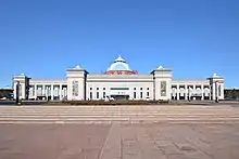
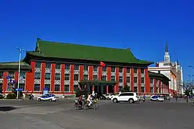 Hulunbuir City Government | |
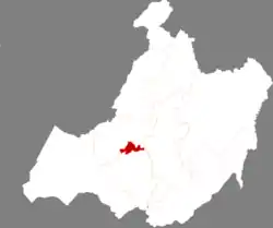 Hailar in Hulunbuir | |
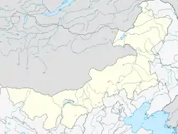 Hailar Location in Inner Mongolia | |
| Coordinates (Genghis Khan Square): 49°12′26″N 119°46′16″E | |
| Country | People's Republic of China |
| Autonomous region | Inner Mongolia |
| Prefecture-level city | Hulunbuir |
| Area | |
| • Total | 1,319.8 km2 (509.6 sq mi) |
| Elevation | 614 m (2,014 ft) |
| Population (2010)[2] | |
| • Total | 270,000 |
| • Density | 200/km2 (530/sq mi) |
| Time zone | UTC+8 (China Standard) |
| Postal code | 021000 |
| Area code(s) | 0470 |
| Website | www |
| Hailar District | |||||||
|---|---|---|---|---|---|---|---|
| Chinese name | |||||||
| Traditional Chinese | 海拉爾區 | ||||||
| Simplified Chinese | 海拉尔区 | ||||||
| |||||||
| Mongolian name | |||||||
| Mongolian Cyrillic | Хайлаар тойрог | ||||||
| Mongolian script | ᠬᠠᠶᠢᠯᠠᠷ ᠲᠣᠭᠣᠷᠢᠭ | ||||||
| |||||||
Long known as the "Pearl of the Grasslands", Hailar acts as a gateway between China and Russia. The district spans an area of 1,319.8 square kilometers,[1] and has an estimated population of 270,000 as of 2010.[2] The district serves as a regional center for commerce, trade, and transportation.
History
Hailar was founded as a Chinese fort in 1734, and during the administration of the Republic of China it was the capital city of Xing'an Province. It was a center of agricultural production on the historical Chinese Eastern Railway. Once known as Hulun, Hailar today is a relatively small but thriving modern industrial city of around 300,000, its population having soared from an estimated 20,000 in the mid-20th century.
After the Mukden Incident in 1931, Japan invaded China's northeastern provinces and established the puppet state of Manzhouguo. Hailar Fortress, a huge underground Japanese fortress was completed in 1937 by forced Chinese laborers. The Kwantung Army garrisoned in Manchuria built the fortress complex as one of biggest Japanese fortifications in Manchuria. Some of the fiercest fighting of the Soviet–Japanese War in August 1945 took place around Hailar. Prisoners of war and civilians were massacred by the Kwantung Army in August 1945 during the final month of World War II.[3][4] World Anti-fascist War Hailar Memorial Park, a museum and war memorial, is built on the site of the Hailar Fortress, and parts of the fortress tunnels are open for public viewing.[4]
Transportation
Hailar Dongshan Airport serves the city, with flights to Beijing and Shenyang amongst others. Hailar's railway station is the penultimate major station before Manzhouli, the port city that stands close to the Russian border. It is on the famous Western line of the Trans-Siberian express route and China National Highway 301. Trains to Harbin take about 12 hours, and 27 to Beijing. Hailar has a frequent series of buses that cover the town.
Geography
Hailar is located in close proximity to the Greater Xing'an Mountains, and has an elevation ranging from 603.0 to 776.6 m (1,978.3 to 2,547.9 ft).[1] Of the city's 1,319.8 square kilometers, 28 square kilometers (or 2.12%) of the district is urban.[1]
Administrative divisions
Hailar is divided into 6 subdistricts and 2 towns: Zhengyang Subdistrict, Kaoshan Subdistrict, Jiankang Subdistrict, Shengli Subdistrict, Hulun Subdistrict, Jianshe Subdistrict, Fendou, and Hake.[2][5]
Climate
Hailar has a humid continental climate (Köppen Dwb) bordering on a subarctic climate (Köppen Dwc). Winters are long, very dry and severe, due to the semi−permanent Siberian High, while summers are short, though very warm, and rather wet, due to the East Asian monsoon. The monthly 24-hour average temperature ranges from −24.8 °C (−12.6 °F) in January to 20.4 °C (68.7 °F) in July, while the annual mean is −0.40 °C (31.3 °F). With monthly percent possible sunshine ranging from 55% in December to 69% in February, sunshine is abundant year-round, and the annual total is 2,719 hours. More than two-thirds of the annual rainfall occurs during the three summer months. The Mohe-Huma-Hailar triangle between northern Heilongjiang and Northeastern Inner Mongolia, which almost equivalent to China's subarctic climate zone, suffers the most severe cold winter in China. Hailar's extreme temperatures ranges from −48.2 to 37.7 °C (−54.8 to 99.9 °F).
| Climate data for Hailar District (1981−2010 normals) | |||||||||||||
|---|---|---|---|---|---|---|---|---|---|---|---|---|---|
| Month | Jan | Feb | Mar | Apr | May | Jun | Jul | Aug | Sep | Oct | Nov | Dec | Year |
| Record high °C (°F) | −1.0 (30.2) |
4.3 (39.7) |
16.2 (61.2) |
29.4 (84.9) |
33.7 (92.7) |
38.8 (101.8) |
39.5 (103.1) |
36.9 (98.4) |
33.2 (91.8) |
26.2 (79.2) |
12.2 (54.0) |
2.4 (36.3) |
39.5 (103.1) |
| Average high °C (°F) | −19.2 (−2.6) |
−13.5 (7.7) |
−3.4 (25.9) |
9.5 (49.1) |
18.4 (65.1) |
24.4 (75.9) |
26.1 (79.0) |
24.3 (75.7) |
17.6 (63.7) |
8.0 (46.4) |
−5.8 (21.6) |
−16.2 (2.8) |
5.8 (42.5) |
| Daily mean °C (°F) | −24.8 (−12.6) |
−20.3 (−4.5) |
−9.9 (14.2) |
3.0 (37.4) |
11.6 (52.9) |
18.0 (64.4) |
20.4 (68.7) |
18.3 (64.9) |
10.8 (51.4) |
1.2 (34.2) |
−11.7 (10.9) |
−21.4 (−6.5) |
−0.4 (31.3) |
| Average low °C (°F) | −29.2 (−20.6) |
−25.7 (−14.3) |
−15.8 (3.6) |
−3.0 (26.6) |
4.4 (39.9) |
11.4 (52.5) |
14.9 (58.8) |
12.8 (55.0) |
5.0 (41.0) |
−4.0 (24.8) |
−16.3 (2.7) |
−25.7 (−14.3) |
−5.9 (21.3) |
| Record low °C (°F) | −42.9 (−45.2) |
−42.3 (−44.1) |
−32.5 (−26.5) |
−21.6 (−6.9) |
−8.4 (16.9) |
0.1 (32.2) |
5.3 (41.5) |
2.5 (36.5) |
−7.9 (17.8) |
−20.5 (−4.9) |
−38.0 (−36.4) |
−40.1 (−40.2) |
−42.9 (−45.2) |
| Average precipitation mm (inches) | 4.6 (0.18) |
3.6 (0.14) |
6.0 (0.24) |
13.9 (0.55) |
22.7 (0.89) |
55.1 (2.17) |
94.0 (3.70) |
88.0 (3.46) |
33.6 (1.32) |
16.7 (0.66) |
6.4 (0.25) |
7.4 (0.29) |
352.0 (13.86) |
| Average precipitation days (≥ 0.1 mm) | 7.6 | 5.9 | 5.6 | 5.9 | 7.0 | 12.9 | 14.5 | 12.4 | 9.5 | 6.2 | 7.1 | 9.6 | 104.2 |
| Average relative humidity (%) | 78 | 78 | 69 | 52 | 46 | 59 | 69 | 70 | 64 | 62 | 73 | 79 | 67 |
| Mean monthly sunshine hours | 167.0 | 195.6 | 244.1 | 246.2 | 298.0 | 285.9 | 279.8 | 268.7 | 218.6 | 210.1 | 165.3 | 139.4 | 2,718.7 |
| Percent possible sunshine | 63 | 69 | 67 | 60 | 63 | 59 | 58 | 60 | 58 | 63 | 60 | 55 | 61 |
| Source: China Meteorological Administration (precipitation days and sunshine 1971–2000)[6][7] | |||||||||||||
Culture
Hailar is a multi-ethnic town, with notable Han, Mongolian, Hui, Daur, Evenki, Russian populations.[2] As such, signs are usually bilingual and Mongolian influence pervades in songs played on shop CD players, domes on buildings and the chitter chatter of some locals.
Composer Vladimir Ussachevsky was born in Hailar, as well as leading news anchor Bai Yansong;[8] the folk metal band Nine Treasures also originated in Hailar.[9]
Sister city
 Chita, Zabaykalsky Krai, Russia.[10]
References
- 走进海拉尔 (in Chinese). Hailar District People's Government. Archived from the original on 2019-10-20. Retrieved 2020-05-30.
- 海拉尔区概况地图. XZQH.org. 2013-04-23. Retrieved 2020-05-31.
- Zapotoczny, Walter (2017). Beyond Duty: The Reason Some Soldiers Commit Atrocities. Fonthill Media. p. 171.
- Wang, Kaihao (August 8, 2013). "Tale as old as the grassland". China Daily.
- 2019年统计用区划代码. National Bureau of Statistics of the People's Republic of China. Retrieved 2020-05-31.
- 中国气象数据网 - WeatherBk Data (in Chinese). China Meteorological Administration. Retrieved 2020-04-15.
- 中国地面国际交换站气候标准值月值数据集(1971-2000年). China Meteorological Administration. Archived from the original on 2013-09-21. Retrieved 2010-05-25.
- Song, Yuwu (2013). Biographical Dictionary of the People's Republic of China. McFarland. p. 15.
- ago, Matt Nolan 3 years (2015-03-31). "Nine Treasures – Mongolian Nomadic Folk Metal". AudioPhix. Retrieved 2019-02-04.
- "Sister cities of Inner Mongolia". Archived from the original on 2013-05-14. Retrieved 2009-01-03.
External links
| Wikimedia Commons has media related to Hailar. |
