Howick, New Zealand
Howick is an affluent eastern suburb of Auckland, New Zealand, forming part of what is sometimes called East Auckland. Modern Howick draws much of its character from the succeeding waves of Asian Settlement that it has observed since New Zealand’s immigration reforms of the 80s; With a strong Chinese New Zealander presence in the suburb’s Business and Education communities. Owing to the relatively numerous remaining heritage buildings and other historical remnants from its early European settlement past, it has been called "perhaps Auckland's most historically conscious place." [1]
Howick | |
|---|---|
Suburb | |
 Howick village seen from above | |

| |
| Country | New Zealand |
| Local authority | Auckland Council |
| Electoral ward | Howick Ward |
| Local board | Howick Local Board |
| Established | 1847 (European)[1] |
| Population (2018) | |
| • Total | 11,067 |
| Eastern Beach | (Hauraki Gulf) | Mellons Bay |
| Half Moon Bay |
|
Cockle Bay |
| Highland Park | Botany Downs | Shelly Park |
Demographics
| Year | Pop. | ±% p.a. |
|---|---|---|
| 2006 | 9,798 | — |
| 2013 | 10,512 | +1.01% |
| 2018 | 11,067 | +1.03% |
| Source: [2] | ||
Howick, comprising the statistical areas of Howick West, Howick Central and Howick East, had a population of 11,067 at the 2018 New Zealand census, an increase of 555 people (5.3%) since the 2013 census, and an increase of 1,269 people (13.0%) since the 2006 census. There were 3,822 households. There were 5,325 males and 5,739 females, giving a sex ratio of 0.93 males per female, with 2,199 people (19.9%) aged under 15 years, 2,058 (18.6%) aged 15 to 29, 5,184 (46.8%) aged 30 to 64, and 1,626 (14.7%) aged 65 or older.
Ethnicities were 67.6% European/Pākehā, 6.2% Māori, 3.8% Pacific peoples, 27.1% Asian, and 3.5% other ethnicities (totals add to more than 100% since people could identify with multiple ethnicities).
The proportion of people born overseas was 46.1%, compared with 27.1% nationally.
Although some people objected to giving their religion, 46.1% had no religion, 39.2% were Christian, and 8.3% had other religions.
Of those at least 15 years old, 2,469 (27.8%) people had a bachelor or higher degree, and 1,107 (12.5%) people had no formal qualifications. The employment status of those at least 15 was that 4,647 (52.4%) people were employed full-time, 1,239 (14.0%) were part-time, and 279 (3.1%) were unemployed.[2]
History

Māori origins
The local iwi (Māori tribe) was Ngāi Tai, people of Tainui descent. They had lived there for around 300 years with pā (fortified villages) at Ōhuiarangi (Pigeon Mountain), Te Waiarohia (Musick Point) and Tūwakamana (Cockle Bay).
Fencible settlement

The Howick, Pakuranga, and Whitford areas were part of the Fairburn claim. William Thomas Fairburn, with his wife and family, established a Church Missionary Society Mission Station at Maraetai in 1836. The local Māori insisted they buy the 40,000 acres (162 km²) between the Tamaki and Wairoa Rivers to prevent attack by the Ngapuhi and Waikato tribes. Fairburn bought the land with his life savings.[3]
In 1840, following the Treaty of Waitangi, the Government took 36,000 acres (146 km²) which it used for the Fencible settlements of Otahuhu and Howick and sold most of the remaining land to settlers.
Howick itself is named after Henry George Grey, 3rd Earl Grey as Viscount Howick, who was Secretary for the Colonies in the British Parliament and was responsible for the Royal New Zealand Fencible Corps immigration scheme. The suburb was therefore established in 1847 as a fencible settlement, where soldiers were given land with the implied understanding that in wartime, they would be raised as units to defend it (however, the eventual fighting a decade later used professional soldiers instead). A relatively large amount of the early features from this time have been retained.[1]
The Māori welcomed the Fencibles to Howick and recognised the advantages of co-operation and trade.[4] Māori labourers built the Fencibles cottages under Royal Engineers supervision, although it was noted that initially, the Europeans had to live in raupo huts, having been falsely promised that houses would already be available for them and their families.[1] There were about 250 Fencibles in Howick. Local Māori had been taught to read and write by the Fairburn LMS missionaries at Maraetai. The Fencibles and their families were poor with no capital apart from a small number of officers. About half were Catholic and half Protestant. Quite a few of the adults were illiterate. 101 Howick fencibles served with their sons in the 1860s New Zealand Wars.[3]
Howick's links to Auckland's pioneering and Fencible past has influenced its development and is also evident in the names of many streets. Others are significantly named for British military heroes or battles. Bleakhouse (as in Bleakhouse Rd) was the name given to a Fencible officer's house built in Bleakhouse Rd for Surgeon-Captain John Bacot who became a magistrate in Howick.
Other roads such as Bacot, Bell, Fencible Drive, Montressor Place and Sale Street, plus many others, also have Fencible connexions, e.g. Sir Robert Sale was one of the ships which brought the Fencibles to Auckland in the 19th century. Montressor Place was named for Captain Charles Henry Montressor-Smith who arrived in Howick with the First Battalion of Fencibles in 1847. He later moved to a property in neighbouring Pakuranga, where his house, known as Bell House, still stands at the end of Bell Rd next to the Howick Historical Village.

Moore St was named after General Sir John Moore, a British military hero, who lived from 1761–1809. General Moore fought against Napoleon alongside Sir David Baird for whom Baird St was named and he (Moore) died at Corunna during the Peninsular War whilst serving under the Duke of Wellington. At Corunna he was attended by Dr J. Bacot, father of the Howick Fencible doctor, who lived in Bleakhouse. Moore St was part of the original Fencible village and was sub-divided into one acre (4,000 m²) allotments down to Rodney St. People will, no doubt, recognise that Wellington and Nelson Sts spring from the most famous of British war heroes, Lord Nelson and the Duke of Wellington and that Selwyn Rd takes its name from the first Bishop of New Zealand, George Augustus Selwyn.
Then there are streets such as Granger Road named for John Granger, manager of the brickworks, which once stood at Little Bucklands Beach near the rock outcrop where the Bucklands Beach Centre board clubrooms now stand, before moving to Whitford. Litten Rd and John Gill Rd are named after the former farmer and landowner families. An Irishman, John Gill, settled in Howick in the 1850s, and his family farmed the land that is now Cockle Bay and Shelly Park. Litten Road is the boundary of one of the old Gill-Litten farms. To the north of Picton Street, the main street of Howick is Stockade Hill. In 1863 a field work was constructed on what is now called Stockade Hill, for the purpose of defending Auckland from Māori who might advance overland from the south, or by canoes from the Firth of Thames. The ditches of the stockade can still be seen today. In the centre is a war memorial where services are held each ANZAC Day.
Growth into town and suburb
Settlement in Howick centred around the domain, and the village developed as a service centre for the prosperous farming community. Later the centre of Howick shifted to Picton Street which is now the centre. It later became popular as a retirement and seaside holiday location.
In 1865 Howick became a road board district; in 1922 it was created an independent town district; and on 1 February 1952 it was constituted a borough with Elections for Mayor and Council being held on 22 March 1952.
The 1930s saw the construction of a concrete all-weather road running all the way from Howick through Pakuranga to Panmure. This allowed the rapid passage of people and goods to and from Auckland. This concrete road can still be seen, in parts, on the highway between Howick and Pakuranga.
From the late 1940s to the 1970s the Howick area experienced rapid growth, when in 1947, at its centenary, it had still been a town of only 1,500. Up until the 1980s Howick was surrounded on all sides by farmland, but as Auckland grew and new subdivisions were created Howick was consumed by urban sprawl.
In 1989 the local government reorganisation in New Zealand saw Howick become a ward within Manukau City, with its Borough Council being replaced by a Community Board and Councillor representation.
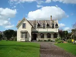
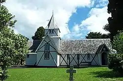
Today Howick is one of the more affluent seaside suburbs of the former Manukau City (now merged with Auckland). It has some of the oldest buildings in the Auckland area, as well as the first parish church in Auckland (All Saints Church).
In July 2008 the community radio station, East FM (formerly Howick Village Radio), was established on 88.1 FM broadcasting over most of the eastern suburb and on 107.1 FM broadcasting into Botany, Flat Bush, and East Tamaki. Worldwide streaming is also available from their website. They have a variety of shows including some hosted by students from local schools.
Asian Settlement
Following the range of Immigration Reforms passed by New Zealand’s parliament in the early 1980s, Howick alongside much of East-Auckland’s suburban cluster observed a dramatic shift in its demographic makeup, as thousands of newly-arrived Asian Immigrants began to form settlements in the area; Altering the suburb’s then predominating European character in their image, bringing with them Chinese academic and cultural institutions, Cherry Blossom lined streets, and new housing developments built on the principles of Feng-Shui.
The congregation of Affluent Asian New Zealanders in Howick and Botany Downs did much to further feed into the narrative of the area as being a ‘Wealthy Asian Enclave’, which had started to arise as the presence of New Zealanders of other ethnicities begun to be eclipsed by the newly conceived Asian Character of East Auckland.
Fo Guang Shan Temple in Howick stands as a monolithic symbol of Asian New Zealander relevance and legitimacy in the Greater Auckland Region.
Howick electorate
From 1993 and prior to the introduction of MMP in 1996, Howick had its own seat in Parliament, Howick; which had been created from part of the former Otara electorate.
In the 1996 general election, due to the need to decrease the number of general electorates in order to ensure a sufficient number of seats were available for list MPs, the population centres formerly in the Howick seat were merged into the former separate seat of Pakuranga.
While making recommendations for the boundaries to apply in the 2008 general election, the Electoral Commission recently proposed to resurrect the Howick seat. The planned seat would have taken in the population centres of Howick and Botany Downs-Dannemora but would have had the effect of splitting Bucklands Beach and Highland Park across two electorates. Due to this, and the planned move to incorporate Panmure, Point England and Glen Innes into the neighbouring Pakuranga seat, the Commission received a significant number of objections from Pakuranga residents. The Commission eventually adopted the recommendation of Objector N17/30 in keeping the Howick suburb in Pakuranga and renaming the new seat Botany, with a corresponding shift in centre of gravity to the new suburb of Flat Bush. [6][7]
Mayors of Howick
During its existence from 1952 to 1989, the borough of Howick had six mayors:[8]
| Name | Term | |
|---|---|---|
| 1 | Ernie La Roche | 1952–1953 |
| 2 | William Stevenson | 1953–1962 |
| 3 | Walter Haddrell | 1962–1965 |
| 4 | Cecil Litten | 1965–1966 |
| 5 | Whitford Blundell | 1966–1974 |
| 6 | Morrin Cooper | 1974–1989 |
Economy
Sport and recreation
Howick is home to Fencibles United association football club, who compete in the Lotto Sport Italia NRFL Division 2, and the Howick Hornets rugby league club, who compete in Auckland Rugby League's top division, the Fox Memorial.
Within the Howick ward there are two 18 hole golf courses. The Howick golf club and course located at Musick Point and the Pakuranga golf club and course, influencing the name of the suburb surrounding it, Golflands.
Education
Howick Intermediate is an intermediate school (years 7–8) with a roll of 477.[10]
Howick Primary School and Owairoa School are contributing primary schools (years 1–6) with rolls of 332 and 850 students, respectively[11][12]
All these schools are coeducational. Rolls are as of March 2020.[13]
Climate
Under the Köppen climate classification, Howick has an oceanic climate (Köppen climate classification Cfb), with warm humid summers and mild damp winters.[14]
Temperature
Compared to other places on a similar latitude (particularly those in the northern hemisphere), there are relatively small variations in temperature between summer and winter, as well as relatively small temperature variations throughout the day. This is due to the proximity and influence of the surrounding ocean curtailing any extremes in temperature. Air temperatures below 0 °C (32 °F) and above 29 °C (84 °F) are rare, both being recorded on average only once every 2–3 years. The maximum recorded temperature is 30.7 °C (87 °F) and minimum −1.4 °C (29 °F). Average summer daily maximum & minimum temperatures are around 25 °C (77 °F) and 16 °C (61 °F). Humidity in summer can at times be oppressive and tropical-like with Dew Point temperatures occasionally exceeding 21 °C (70 °F). Average winter daily maximum & minimum temperatures are around 15 °C (59 °F) and 7 °C (45 °F). Mean annual temperature is 15.4 °C (60 °F).
Rainfall
Rainfall is usually plentiful throughout the year averaging around 1,200 millimetres (47.24 in) however the winter months on average see more rain than the summer months. Between December and April, storms from the tropics can occasionally pass through or near the region bringing with it heavy rain. The highest 30-day rainfall of 417.2 millimetres (16.43 in) was recorded during the period 7 March 2017 – 5 April 2017 and includes the record highest daily rainfall of 93 millimetres (3.66 in) on 4 April 2017. The most consecutive wet days (≥1 mm) is 12 recorded in the period 26 July 2016 – 6 August 2016. The lowest 30-day rainfall of 2.2 millimetres (0.09 in) was recorded in the period 15 January 2020 - 13 March 2020 and the most consecutive non-wet days (<1 mm) is 29 recorded 2 January 2015 – 30 January 2015. There are no recorded instances of snowfall. Occasionally droughts do occur during the warmer months, for example the 3 months Jan-Mar 2013 saw only 51 millimetres (2.01 in) of rainfall, and the 6 months Nov 2019 - Apr 2020 saw only 154 millimetres (6.06 in) of rainfall.
Climate Data
| Climate data for Howick (Jan 2010 - Dec 2020) | |||||||||||||
|---|---|---|---|---|---|---|---|---|---|---|---|---|---|
| Month | Jan | Feb | Mar | Apr | May | Jun | Jul | Aug | Sep | Oct | Nov | Dec | Year |
| Record high °C (°F) | 30.2 (86.4) |
30.7 (87.3) |
27.4 (81.3) |
25.5 (77.9) |
22.6 (72.7) |
19.3 (66.7) |
18.7 (65.7) |
19.4 (66.9) |
21.9 (71.4) |
22.8 (73.0) |
26.7 (80.1) |
28.9 (84.0) |
30.7 (87.3) |
| Mean maximum °C (°F) | 28.1 (82.6) |
28.1 (82.6) |
26.2 (79.2) |
24.5 (76.1) |
21.3 (70.3) |
18.7 (65.7) |
17.6 (63.7) |
18.7 (65.7) |
20.2 (68.4) |
22.0 (71.6) |
24.7 (76.5) |
26.6 (79.9) |
28.7 (83.7) |
| Average high °C (°F) | 24.6 (76.3) |
25.2 (77.4) |
23.6 (74.5) |
20.9 (69.6) |
18.1 (64.6) |
15.7 (60.3) |
14.8 (58.6) |
15.6 (60.1) |
17.0 (62.6) |
18.9 (66.0) |
20.9 (69.6) |
23.1 (73.6) |
19.9 (67.8) |
| Daily mean °C (°F) | 19.9 (67.8) |
20.3 (68.5) |
18.8 (65.8) |
16.4 (61.5) |
13.9 (57.0) |
11.9 (53.4) |
10.6 (51.1) |
11.4 (52.5) |
12.7 (54.9) |
14.4 (57.9) |
16.2 (61.2) |
18.5 (65.3) |
15.4 (59.7) |
| Average low °C (°F) | 15.7 (60.3) |
16.1 (61.0) |
14.6 (58.3) |
12.3 (54.1) |
10.1 (50.2) |
8.4 (47.1) |
7.1 (44.8) |
7.7 (45.9) |
9.0 (48.2) |
10.5 (50.9) |
12.1 (53.8) |
14.6 (58.3) |
11.5 (52.7) |
| Mean minimum °C (°F) | 11.2 (52.2) |
11.7 (53.1) |
9.8 (49.6) |
6.8 (44.2) |
3.1 (37.6) |
2.3 (36.1) |
0.4 (32.7) |
2.2 (36.0) |
3.5 (38.3) |
5.3 (41.5) |
7.5 (45.5) |
9.9 (49.8) |
0.3 (32.5) |
| Record low °C (°F) | 9.1 (48.4) |
8.5 (47.3) |
6.3 (43.3) |
4.8 (40.6) |
0.3 (32.5) |
−0.4 (31.3) |
−1.4 (29.5) |
0.2 (32.4) |
0.1 (32.2) |
3.1 (37.6) |
5.3 (41.5) |
7.4 (45.3) |
−1.4 (29.5) |
| Average precipitation mm (inches) | 67.1 (2.64) |
62.4 (2.46) |
97.1 (3.82) |
99.0 (3.90) |
122.7 (4.83) |
142.5 (5.61) |
135.8 (5.35) |
135.0 (5.31) |
120.9 (4.76) |
74.9 (2.95) |
68.5 (2.70) |
86.0 (3.39) |
1,211.8 (47.71) |
| Average precipitation days (≥ 1.0 mm) | 6.4 | 7.3 | 7.7 | 9.7 | 12.9 | 14.1 | 14.8 | 16.2 | 15.0 | 10.9 | 9.2 | 8.4 | 132.5 |
| Source: Howick Weather Station[15] | |||||||||||||
References
- "Auckland: Soldiers of fortune". The New Zealand Herald. 26 August 2010. Retrieved 5 February 2011.
- "Statistical area 1 dataset for 2018 Census". Statistics New Zealand. March 2020. Howick West (150400), Howick Central (152000) and Howick East (152400). 2018 Census place summary: Howick West 2018 Census place summary: Howick Central 2018 Census place summary: Howick East
- R. Alexander G. Gibson. The Royal NZ Fencibles, 1847–1852. A LaRoche. Deed. Waiuku (1997), pp. 51–60.
- "Fencibles try to settle". Howick & Pakuranga Times. 21 December 2017. Retrieved 1 January 2020.
- "Old All Saints Church (Anglican)". Register of Historic Places. Heritage New Zealand. Retrieved 27 January 2021.
- "Archived copy". Archived from the original on 16 October 2007. Retrieved 10 November 2007.CS1 maint: archived copy as title (link)
- "Find my Electorate". Electoral Commission. Retrieved 12 May 2019.
- "Timeline of Auckland mayors". Auckland Council Archives. Retrieved 8 January 2021.
- "$100 Million Of Retail Property Sales". scoop.co.nz. Bayleys Real Estate. 26 May 2020.
- Education Counts: Howick Intermediate
- Education Counts: Howick Primary School
- Education Counts: Owairoa School
- "New Zealand Schools Directory". New Zealand Ministry of Education. Retrieved 26 April 2020.
- Peel, M. C. and Finlayson, B. L. and McMahon, T. A. (2007). "Updated world map of the Köppen–Geiger climate classification" (PDF). Hydrol. Earth Syst. Sci. 11 (5): 1633–1644. doi:10.5194/hess-11-1633-2007. ISSN 1027-5606.CS1 maint: uses authors parameter (link)
- "Howick Weather | Climate". howickweather.co.nz. Retrieved 1 January 2021.
Further reading
- La Roche, A. (1991), The history of Howick and Pakuranga, The Howick & District Historical Society (Inc.), ISBN 0-473-01206-5
- "Howick", The Cyclopedia of New Zealand, 2: Auckland Provincial District, Christchurch: The Cyclopedia Company, Limited, 1902, pp. 656–657 – history of the town to 1900 and biographies of some local notable people during the latter half of the 19th century.
External links
- Howick Historical Village
- Howick Village
- East FM
- Howick Historic Walk
- Howick Little Theatre Incorporated
- Photographs of Howick held in Auckland Libraries' heritage collections.