Hui County
Hui County or Huixian (simplified Chinese: 徽县; traditional Chinese: 徽縣; pinyin: Huī Xiàn) is a county under the administration of Longnan City, in the southeast of Gansu Province, China, bordering Shaanxi province to the south. The postal code is 742300.[2]
Hui County
徽县 | |
|---|---|
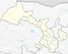 Huixian Location of the seat in Gansu | |
| Coordinates: 33°51′54.00″N 106°01′19.20″E | |
| Country | People's Republic of China |
| Province | Gansu |
| Prefecture-level city | Longnan |
| Area | |
| • Total | 2,722.9 km2 (1,051.3 sq mi) |
| Highest elevation [1] (near Jialing Town) | 2,504 m (8,215 ft) |
| Lowest elevation [1] (near Yuguan Township) | 704 m (2,310 ft) |
| Population (2015) | |
| • Total | 223,500 |
| • Density | 82/km2 (210/sq mi) |
| Time zone | UTC+8 (China Standard) |
| Postal code | 742300 |
| Website | zwfw |
The population was 209,113 in 1999.[3]
Administrative divisions
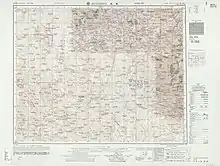
Map including Hui County (labeled as HUI-HSIEN (HWEIHSIEN) (walled) 徽縣) (AMS, 1955)
Hui County is divided into 13 towns and 2 townships:[4]
- Towns
|
|
-Towns are upgraded from Township.
|
|
- Townships
- Yushu Township (榆树乡)
- Yuguan Township (虞关乡)
References
- http://gshxzf.gov.cn/cms/page/detail/id/4.html
- (in English) Gansu postal codes Archived 2008-01-24 at the Wayback Machine
- (in English) National Population Statistics Materials by County and City - 1999 Period, in China County & City Population 1999, Harvard China Historical GIS
- "统计用区划代码 www.stats.gov.cn" (in Chinese). XZQH. Retrieved 2012-05-26.
This article is issued from Wikipedia. The text is licensed under Creative Commons - Attribution - Sharealike. Additional terms may apply for the media files.