Hurricane Paulette
Hurricane Paulette was the first tropical cyclone to make landfall in Bermuda since Gonzalo in 2014. The sixteenth named storm and sixth hurricane of the record-breaking 2020 Atlantic hurricane season, Paulette developed from a tropical wave on September 7. Due to relatively favorable conditions, Paulette gradually strengthened into a strong tropical storm, though an increase in wind shear caused it to weaken. Wind shear continued to increase to the south of the system, but despite the shear, Paulette unexpectedly strengthened back into a strong tropical storm on September 11, with deep convection located just north of the center. A dry air inclusion caused the cyclone's structure to become disheveled on September 12, though Paulette quickly recovered and strengthened into a hurricane at 03:00 UTC on September 13. Paulette then developed a closed eyewall and a clear eye as it steadily strengthened and moved towards Bermuda. Early on September 14th, Paulette made landfall in northeastern Bermuda as a Category 1 hurricane while making a sharp turn to the north. It then further strengthened into a Category 2 hurricane as it moved away from the island, reaching its peak intensity on September 14 with winds of 105 mph (165 km/h) and a pressure of 965 mbar (28.50 inHg). On the evening of September 15, it began to weaken and undergo extratropical transition, which it completed on September 16. Paulette's extratropical remnants persisted and moved southwards then eastwards, and eventually regenerated into a tropical storm early on September 22 south of the Azores. This proved to be short lived, however, as the storm quickly weakened and became post-tropical again only a day later. The remnants persisted for another week before dissipating south of the Azores on September 30.
| Category 2 hurricane (SSHWS/NWS) | |
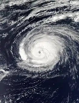 Hurricane Paulette just before its peak intensity north of Bermuda on September 14 | |
| Formed | September 7, 2020 |
|---|---|
| Dissipated | September 30, 2020 |
| (Remnant low after September 23) | |
| Highest winds | 1-minute sustained: 105 mph (165 km/h) |
| Lowest pressure | 965 mbar (hPa); 28.5 inHg |
| Fatalities | 1 total |
| Damage | ≥ $50 million (2020 USD) |
| Areas affected | Cape Verde, Bermuda, East Coast of the United States, Azores, Madeira |
| Part of the 2020 Atlantic hurricane season | |
Paulette brought hurricane-force sustained winds and heavy rain to Bermuda, causing widespread power outages. Storm surge caused considerable damage to several waterfront properties. Large swells affected the U.S. mainland, and a 60-year-old man drowned off the coast of New Jersey after getting caught in the rough surf. No impacts were recorded from Paulette's second stint as a tropical cyclone. Paulette's damage totals were estimated to be around $50 million.[1]
Meteorological history

At 12:00 UTC on August 30, the National Hurricane Center (NHC) began to track a tropical wave located over Africa for possible development once it moved into the Tropical Atlantic.[2] By 12:00 UTC on September 2, the wave emerged over water, where it began to slowly organize.[3] The wave merged with two disturbances to its southwest between September 3-4 and September 5 respectively and formed a broad area of low pressure on September 6, but convective activity remained disorganized.[4][5][6][7][8] Early the next morning, the low's shower and thunderstorm activity became more organized and better defined, and the NHC began issuing advisories for Tropical Depression Seventeen at 03:00 UTC on September 7. At the time of formation, the depression was located about 1,160 miles (1,865 km) west of the Cabo Verde Islands and about 1,425 miles (2,290 km) east of the Northern Leeward Islands.[9]
Before becoming a tropical depression, the storm had previously struggled to organize due to short-lasting convective bursts with little consistency.[10] It continued to have an elongated center, but at 15:00 UTC on September 7, ASCAT data confirmed that the depression had strengthened, and the NHC upgraded the system to Tropical Storm Paulette.[11] This was the earliest 16th named Atlantic storm ever recorded, shattering the previous record set by 2005's Hurricane Philippe by 10 days.[11][12] It moved generally west-northwestward over the warm Atlantic waters and gradually intensified despite the presence of southwesterly wind shear, which gave it a sheared appearance on satellite.[13] At 15:00 UTC on September 8, Paulette reached its first peak intensity with 1-minute sustained winds of 65 mph (100 km/h) with a minimum central pressure of 995 mbars (29.39 inHg).[14] It held this intensity for roughly 12 hours before increasing wind shear as a result of a large upper-level trough to the storm's northwest once again put a halt to intensification and weakened the storm.[15] The storm's circulation soon became exposed later on September 9, although weakening remained slow.[16]

Fluctuations in intensity became apparent as Paulette headed northwest and the storm's winds fell to 50 mph (80 km/h) later that day but very quickly raised back up to 65 mph (100 km/h) on September 10 despite Paulette being located in a region of at least 45 knots (50 mph) of wind shear, well above the proper values required for intensification of a typical tropical cyclone.[17] As it exited this unfavorable environment it continued to intensify, nearing hurricane strength and displaying an eye-like feature on visible satellite imagery.[18][19] A Hurricane Hunter reconnaissance aircraft flown into the storm later found Paulette had intensified to a hurricane on 21:00 UTC, September 12 on its approach to Bermuda.[20] Although occasional dry air intrusions prevented quick intensification of Paulette, the hurricane slowly became more organized into September 13 as a ragged eye formed.[21] Paulette later made landfall in Bermuda around 09:00 UTC, September 14 as a high-end Category 1 hurricane with winds of 90 mph (145 km/h) and a pressure of 973 mb (28.74 inHg).[22] Paulette continued to intensify after impacting Bermuda, becoming a Category 2 hurricane north of Bermuda and reaching its peak intensity at 18:00 UTC with winds of 105 mph (165 km/h) and a pressure of 965 mbar (28.50 inHg) as it turned northeast.[23] Paulette started to weaken 21 hours later as it began extratropical transition and the eyewall was eroded by dry air.[24] It completed the transition at 15:00 UTC on September 16 and the NHC issued their final advisory.[25]

The powerful extratropical cyclone subsequently slowed down some and turned southward in the direction of the Azores, where the NHC began to monitor it again for possible redevelopment.[26][27] Convective activity soon began to occur northeast of the circulation, although the circulation remained ill-defined.[28] Thunderstorms began to wrap around the low by September 20, and on September 22 at 03:00 UTC the NHC determined Tropical Storm Paulette had re-formed about 300 miles (480 km) south-southeast of the Azores.[29][30] Paulette continued eastward after its regeneration, obtaining a third peak intensity of 60 mph (95 km/h) and a pressure of 1002 mb (29.59 inHg) six hours later, although by that time, its thunderstorms were already beginning to quickly wane.[31] The storm briefly gained an eye-like feature surrounded by shallow convection before yet again becoming post-tropical at 03:00 UTC on September 23.[32][33] Early on September 24, Paulette's remnant low curved westward, as the system reached the south side of the Azores High. Paulette's remnant low continued moving westward for the next few days before turning back eastward, as the system made a clockwise loop.[34][35] Paulette passed south of the Azores again, before finally dissipating on September 30.
Preparations and impact

The approach of Paulette prompted the Bermuda government to issue a tropical storm watch at 03:00 UTC on September 12.[36] This was upgraded to a tropical storm warning and hurricane watch at 09:00 UTC before a hurricane warning was issued at 15:00 UTC.[37][38] Multiple observing stations in Bermuda started reporting tropical-storm-force wind gusts beginning at 23:00 UTC on September 13 with sustained tropical-storm-force winds coming soon after.[39] Early on September 14, a wind gust of 117 mph (189 km/h) was measured at the Marine Operations Center (MAROPS), which is elevated at 290 ft above sea level.[40] This came just over an hour after an island-wide power outage affected all of Bermuda, including the Bermuda Weather Service, with only cell phone service remaining active. This led to over 20,000 people losing electrical service.[41] By September 17, 250 customers still remained without power on the island.[42] There were no reported casualties or serious property damage in Bermuda but many trees and some power lines were downed across the island.[43][44] Total damage in Bermuda was estimated at $50 million.[1]
In the United States, swells as high as 10 ft (3 m) affected the East Coast on September 15 and prompted the issuance of several high surf advisories around the coastline.[45] Despite these warnings of high rip current risk by the National Weather Service, a 60-year-old man drowned while swimming in Lavallette, New Jersey after getting caught in rough surf produced by Hurricane Paulette.[46]
See also
- Tropical cyclones in 2020
- List of Category 2 Atlantic hurricanes
- List of Bermuda hurricanes
- Hurricane Fabian (2003) – Made a direct hit on Bermuda as a Category 3 hurricane, causing heavy damage
- Hurricane Igor (2010) – A large hurricane that passed close to Bermuda as a Category 1, causing minor damage
- Hurricanes Fay and Gonzalo (2014) – Two hurricanes that made landfalls on Bermuda a week apart
- Hurricane Nicole (2016) – Made a direct hit on Bermuda as a Category 3 hurricane, bringing moderate damage
- Hurricane Teddy (2020) – Another hurricane of the same year that also impacted Bermuda
References
- "Global Catastrophe Recap October 2020" (PDF). Aon. November 11, 2020. Retrieved November 11, 2020.
- Stacy Stewart (August 30, 2020). "Five-Day Graphical Tropical Weather Outlook". www.nhc.noaa.gov. Miami, Florida: National Hurricane Center. Retrieved September 7, 2020.
- "NHC Graphical Outlook Archive". www.nhc.noaa.gov. Retrieved September 12, 2020.
- "NHC Graphical Outlook Archive". www.nhc.noaa.gov. Retrieved September 12, 2020.
- "NHC Graphical Outlook Archive". www.nhc.noaa.gov. Retrieved September 12, 2020.
- "NHC Graphical Outlook Archive". www.nhc.noaa.gov. Retrieved September 13, 2020.
- John Cangialosi (September 6, 2020). "Two-Day Graphical Tropical Weather Outlook". www.nhc.noaa.gov. Miami, Florida: National Hurricane Center. Retrieved September 7, 2020.
- John Cangialosi (September 6, 2020). "Two-Day Graphical Tropical Weather Outlook". www.nhc.noaa.gov. Miami, Florida: National Hurricane Center. Retrieved September 7, 2020.
- Stacy Stewart (September 7, 2020). "Tropical Depression Seventeen Public Advisory Number 1". www.nhc.noaa.gov. Miami, Florida: National Hurricane Center. Retrieved September 7, 2020.
- Stacy Stewart (September 7, 2020). "Tropical Depression Seventeen Discussion Number 1". www.nhc.noaa.gov. Miami, Florida: National Hurricane Center. Retrieved September 7, 2020.
- David Zelinsky (September 7, 2020). "Tropical Storm Paulette Discussion Number 3". www.nhc.noaa.gov. Miami, Florida: National Hurricane Center. Retrieved September 7, 2020.
- Erdman, Jonathan (September 7, 2020). "Tropical Storm Paulette, Record Earliest 16th Storm, Forms in Eastern Atlantic While Tropical Storm Rene is Soon to Follow". weather.com. The Weather Channel. Retrieved September 7, 2020.
- "Tropical Storm PAULETTE Forecast Discussion Number 8". www.nhc.noaa.gov. Retrieved September 15, 2020.
- David Zelinsky (September 8, 2020). "Tropical Storm Paulette Public Advisory Number 7". www.nhc.noaa.gov. Miami, Florida: National Hurricane Center. Retrieved September 9, 2020.
- "Tropical Storm PAULETTE Forecast Discussion Number 10". www.nhc.noaa.gov. Retrieved September 15, 2020.
- "Tropical Storm PAULETTE Forecast Discussion Number 13". www.nhc.noaa.gov. Retrieved September 15, 2020.
- "Tropical Storm PAULETTE Forecast Discussion Number 15". www.nhc.noaa.gov. Retrieved September 15, 2020.
- "Tropical Storm PAULETTE Forecast Discussion Number 21". www.nhc.noaa.gov. Retrieved September 15, 2020.
- "Tropical Storm PAULETTE Forecast Discussion Number 24". www.nhc.noaa.gov. Retrieved September 15, 2020.
- "Hurricane PAULETTE Forecast Discussion Number 25". www.nhc.noaa.gov. Retrieved September 15, 2020.
- "Hurricane PAULETTE Forecast Discussion Number 28". www.nhc.noaa.gov. Retrieved September 15, 2020.
- "Hurricane PAULETTE Public Advisory Number 30". www.nhc.noaa.gov. Retrieved September 15, 2020.
- "Hurricane PAULETTE". www.nhc.noaa.gov. Retrieved September 16, 2020.
- "Hurricane PAULETTE". www.nhc.noaa.gov. Retrieved September 15, 2020.
- "Post-Tropical Cyclone PAULETTE". www.nhc.noaa.gov. Retrieved September 16, 2020.
- David Zelinsky (September 18, 2020). "Five-Day Graphical Tropical Weather Outlook". www.nhc.noaa.gov. Miami, Florida: National Hurricane Center. Retrieved September 18, 2020.
- "NHC Graphical Outlook Archive". www.nhc.noaa.gov. Retrieved September 18, 2020.
- "NHC Graphical Outlook Archive". www.nhc.noaa.gov. Retrieved September 22, 2020.
- "NHC Graphical Outlook Archive". www.nhc.noaa.gov. Retrieved September 22, 2020.
- Dan Brown (September 21, 2020). Tropical Storm Paulette Public Advisory Number 40 (Report). Miami, Florida: National Hurricane Center. Retrieved September 21, 2020.
- "Tropical Storm PAULETTE Forecast Discussion Number 41". www.nhc.noaa.gov. Retrieved September 24, 2020.
- "Tropical Storm PAULETTE Forecast Discussion Number 43". www.nhc.noaa.gov. Retrieved September 24, 2020.
- "Tropical Storm PAULETTE Forecast Discussion Number 44". www.nhc.noaa.gov. Retrieved September 24, 2020.
- "NHC Graphical Outlook Archive". www.nhc.noaa.gov. Retrieved September 28, 2020.
- "NHC Graphical Outlook Archive". www.nhc.noaa.gov. Retrieved September 28, 2020.
- "Tropical Storm PAULETTE". www.nhc.noaa.gov. Retrieved September 13, 2020.
- "Tropical Storm PAULETTE". www.nhc.noaa.gov. Retrieved September 13, 2020.
- "Tropical Storm PAULETTE". www.nhc.noaa.gov. Retrieved September 13, 2020.
- "Hurricane PAULETTE". www.nhc.noaa.gov. Retrieved September 13, 2020.
- "Hurricane PAULETTE". www.nhc.noaa.gov. Retrieved September 14, 2020.
- "Hurricane PAULETTE". www.nhc.noaa.gov. Retrieved September 14, 2020.
- "250 Without Power: BELCO Working To Restore". Bernews. September 17, 2020. Retrieved September 18, 2020.
- "Knocked down tress and power lines: Damage reported as Hurricane 'Paulette' makes rare landfall in Bermuda". Deccan Herald. September 15, 2020. Retrieved September 15, 2020.
- "Photos & Video: Post Hurricane Paulette". Bernews. September 15, 2020. Retrieved September 18, 2020.
- "Hurricane Paulette to bring 4-to-10-foot waves, dangerous swimming conditions to Massachusetts". masslive. September 15, 2020. Retrieved September 18, 2020.
- "Man drowns at New Jersey shore in seas churned by hurricane". WPVI. September 15, 2020. Retrieved September 15, 2020.
External links
| Wikimedia Commons has media related to Hurricane Paulette. |
Tropical cyclones of the 2020 Atlantic hurricane season | ||
|---|---|---|
 | ||
| ||
