Hurricane Sally
Hurricane Sally was a destructive Atlantic hurricane which became the first hurricane to make landfall in the U.S. state of Alabama since Ivan in 2004, coincidentally on the same date. The eighteenth named storm, and seventh hurricane of the extremely active 2020 Atlantic hurricane season, Sally developed from an area of disturbed weather which was first monitored over the Bahamas on September 10. The system grew a broad area of low-pressure on September 11, and was designated as a tropical depression late that day. Early the next day, the depression made landfall at Key Biscayne, and subsequently strengthened into Tropical Storm Sally that afternoon. Moderate northwesterly shear prevented significant intensification for the first two days, but convection continued to grow towards the center and Sally slowly intensified. On September 14, a center reformation into the center of the convection occurred, and data from a hurricane hunter reconnaissance aircraft showed that Sally rapidly intensified into a strong Category 1 hurricane. It further intensified into a Category 2 hurricane that evening. However, an increase in wind shear and upwelling of colder waters weakened Sally slightly back down to Category 1 on September 15. Despite this increase in wind shear, it unexpectedly re-intensified, reaching Category 2 status again early on September 16 before making landfall at peak intensity at 09:45 UTC on September 16 near Gulf Shores, Alabama, with maximum sustained winds of 105 mph (165 km/h).[1] The storm rapidly weakened after landfall, becoming a remnant low early the next day.
| Category 2 hurricane (SSHWS/NWS) | |
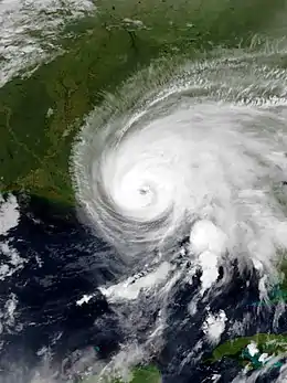 Hurricane Sally intensifying before landfall in Alabama on September 16 | |
| Formed | September 11, 2020 |
|---|---|
| Dissipated | September 18, 2020 |
| (Remnant low after September 17) | |
| Highest winds | 1-minute sustained: 105 mph (165 km/h) |
| Lowest pressure | 965 mbar (hPa); 28.5 inHg |
| Fatalities | 8 total |
| Damage | ≥ $7.3 billion (2020 USD) |
| Areas affected | The Bahamas, Cuba, U.S. Gulf Coast, Southeastern United States, Norway |
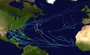
| Part of the 2020 Atlantic hurricane season | |
Numerous watches and warnings were issued in anticipation of the imminent approach of Sally and several coastline counties and parishes on the Gulf Coast were evacuated. In South Florida, heavy rain led to localized flash flooding while the rest of peninsula saw continuous shower and thunderstorm activity due to asymmetric structure of Sally. The area between Mobile, Alabama, and Pensacola, Florida, took the brunt of the storm with widespread wind damage, storm surge flooding, and over 20 inches (510 mm) of rainfall. Several tornadoes also occurred as well. Damage is estimated to be at least $7.3 billion (2020 USD).[2]
Meteorological history
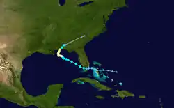
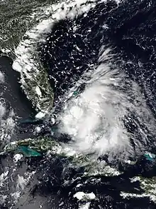
At 00:00 UTC on September 10, the NHC began to monitor an area of disturbed weather over the Bahamas for possible development.[3] Over the next two days, convection rapidly increased, became better organized, and formed a broad area of low-pressure on September 11.[4] At 21:00 UTC, the system had organized enough to be designated as Tropical Depression Nineteen.[5] At 06:00 UTC on September 12, the depression made landfall at Key Biscayne, with winds of 35 mph (55 km/h) and a pressure of 1007 mbar (29.74 inHg).[6] The system maintained its strength crossing Florida, but the NHC noted that a strong convective burst near the center of the cyclone had weakened considerably.[7] Shortly after moving into the Gulf of Mexico, the system strengthened into Tropical Storm Sally at 18:00 UTC the same day, becoming the earliest 18th tropical or subtropical storm in an Atlantic hurricane season, surpassing the old mark of October 2, which was previously set by Hurricane Stan in 2005.[8] As Sally moved north-northwestard, northwesterly shear from a nearby upper-level low caused the system to have a sheared appearance, but it continued to strengthen as it continued to gradually moved north-northwestward.[9] As shear relaxed some, a huge burst of convection and a center reformation caused Sally to rapidly intensify into a hurricane by 16:00 UTC on September 14 with winds of 85 mph (140 km/h) and a pressure of 985 mb (29.09 inHg).[10] It later intensified into a 100 mph (155 km/h) Category 2 hurricane five hours later, although its pressure had risen to 987 mb (29.15 inHg).[9]
This increase in strength did not last long as six hours later, a slight increase in wind shear and upwelling of colder waters caused by the storm's slow motion weakened Sally back to a Category 1 storm early the next day.[9] Despite its weakening, Sally began to develop a ragged eye, as shown on radar imagery, although it was open on its southern side.[11] Sally continued to slowly weaken as it slowed down tremendously and meandered first before turning northward, moving at only 2 mph (3.2 km/h).[12] Although its pressure continued to fall, Hurricane Hunter aircraft reported that wind speeds continued to drop.[9] However, as Sally approached the coast, its eye quickly became better defined and it abruptly began to reintensify.[13] By 05:00 UTC on September 16, the storm had reintensified back into a Category 2 hurricane and was still strengthening.[14] The storm then reached its peak intensity at 08:00 UTC with winds of 105 mph (165 km/h) and a pressure of 965 mbars (28.50 inHg).[15] Sally maintained its intensity before making its final landfall at around 09:45 UTC near Gulf Shores, Alabama.[1][16] Sally's eye quickly disappeared as the storm rapidly weakened while it moved slowly inland. It was downgraded to a Category 1 hurricane at 13:00 UTC and to a tropical storm at 18:00 UTC.[17][18] It further weakened to a tropical depression at 03:00 UTC on September 17 before degenerating into a remnant low at 15:00 UTC.[19][20] The remnants continued northeastward off the coast of the Carolinas before losing its identity within a cold front around 18:00 UTC on September 18.[21][22]
Preparations
Due to the possibility of the storm making landfall as a tropical storm, a tropical storm watch was issued for the coast of Southeastern Florida from south of Jupiter Inlet to north of Ocean Reef when advisories were first issued at 21:00 UTC on September 11.[5] At 03:00 UTC on September 12, another tropical storm watch was issued for the Florida panhandle from the Ochlockonee River to the Okaloosa/Walton County line.[23] That same day, numerous storm surge, tropical storm, and hurricane watches were then issued for a large portion of the US Gulf Coast east of New Orleans at 21:00 UTC, three hours after Sally was named.[8][24] Many of these watches were then upgraded to warnings at 09:00 UTC on September 13 with more watches and warnings issued in the hours that followed.[25][26] Several tornado, flash flood, and flood watches were issued.[27]
States of emergency were declared in the states of Louisiana, Mississippi, and Alabama in preparation for Sally's arrival.[28][29][30] Emergencies were also declared in the East Baton Rouge and St. Bernard parishes in Louisiana and Escambia, Santa Rosa and Okaloosa counties in Florida as well as New Orleans and Pensacola, Florida.[31][32][33][34][35]
Louisiana
The mayor of New Orleans, LaToya Cantrell, issued an evacuation for areas outside the levee system of the city, due to expected storm surge.[36] The governor of Louisiana declared a state of emergency for the entire state, which was still recovering from the devastating effects of Hurricane Laura just three weeks earlier.[28] Several parishes and areas were put under mandatory evacuation orders including all of St. Charles Parish, and parts of Orleans Parish, Jefferson Parish, Plaquemines Parish, and St. John the Baptist Parish.[37] Shelters were opened while public school and university classes were cancelled throughout southeastern Louisiana for September 15.[38] FEMA declared that they will be bringing additional resources to Louisiana for the storm's aftermath and not diverting resources away from Hurricane Laura's relief efforts.[38] Lakeshore Drive along Lake Pontchartrain was closed before the storm as well.[27]
Mississippi

A state of emergency was declared on the night of Sunday, September 13, 2020.[39] Mississippi governor Tate Reeves urged residents to prepare for Sally, which he said could produce up to 20 inches (51 cm) of rain in the southern part of the state. Some shelters were opened, although officials urged people who were evacuating to stay with friends, relatives, or in hotels, if possible, because of the threat of coronavirus superspreading.[40] Mandatory evacuations were ordered for parts of Harrison County and Hancock County.[38][37]
Alabama
Alabama governor Kay Ivey closed all beaches on the coast and called for evacuations of low-lying and flood prone areas.[40] Additionally, Dauphin Island mayor Jeff Collier strongly encouraged all people to evacuate the west end after water started to encroach on the main roadway.[41] A state of emergency was declared by governor Kay Ivey on September 14, 2020 as public schools and university classes were either cancelled or moved online in anticipation of the storm.[42]
Impact

The re-intensification and sudden track to the east by Sally prior to landfall caught many by surprise. Additionally, its slow movement caused coastal areas between Mobile, Alabama, and Pensacola, Florida, to be in the northern eye wall for hours. Over 500,000 customers in Louisiana, Alabama, Florida, and Georgia lost power and parts of I-10, including the Escambia Bay Bridge, were shut down.[43] Widespread tornado, special marine, severe thunderstorm, and flash flood warnings were issued, including several flash flood emergencies.[44][45][46][47][48][49][50][51]
Florida

Due to the asymmetrical structure of Sally, almost all of Florida saw continuous shower and thunderstorm activity starting on September 12. A low-topped supercell in the outer rainbands of Sally prompted a tornado warning east of Tampa near Sebring on September 12.[52] The next day, another storm prompted two tornado warnings in southwestern Lee County.[53] Several special marine warnings were also issued for the Florida coast due to possible waterspouts.[54][55] There was also a tornado reported in Marianna.[56] Sally caused heavy rainfall and moderate flooding in South Florida and the Florida Keys, with nearly 8.5 inches (220 mm) falling over Marathon, over 10 inches (250 mm) in Key West and peaking at 12 inches (300 mm) in Lower Matecumbe Key.[57][58] Tropical storm-force gusts were reported in portions of the Miami metropolitan area.[59]
The Panhandle area suffered the brunt of the storm in Florida. In Escambia County, which includes Pensacola, the sheriff kept police deputies out helping residents "as long as physically possible". Tiger Point saw 36 inches (91 cm) of rain, while Bellview saw 30 inches (76 cm). In Pensacola itself, over 24 inches (61 cm) of rain fell and storm surge flooding reached 5.6 feet (1.7 m), the third highest surge ever recorded in the city.[27] Many streets were flooded and several parked cars were totaled when water got into their engines. Late on September 15, twenty two barges in the Pensacola Bay broke loose due to heavy surf. Five of the barges washed up near downtown while the sixth was involved in another collision. The seventh lodged itself underneath the Garcon Point Bridge while the final one became lodged underneath the Pensacola Bay Bridge, causing the bridge to be temporarily closed.[60][61] The next morning, a crane fell onto the same bridge, destroying a portion of the roadway.[62] The Florida Department of Transportation was unable to assess any possible damage to the bridge due to ongoing high winds.[60] A water main break occurred in nearby Pensacola Beach, causing officials to advise residents to fill their bathtubs with water.[63] The city of Panama City reported releases of raw sewage from several locations due to flooding from Hurricane Sally, prompting The Florida Department of Health to issue advises against swimming in Panama City until further notice.[64] In Pensacola, a 27-year-old boater went missing when he left his home in a 12-foot jon, in an attempt to find his mother's pontoon boat that became untethered in the strong currents and whipping winds brought on by the hurricane; one week after his disappearance, his body was found washed ashore near the Blue Angel Recreation Park.[65] Another person in Pensacola also died after succumbing to carbon monoxide poisoning from indoor generator use.[66] The body of another missing boater, a 45-year-old female kayaker who had also gone missing at the height of the storm, was discovered, marking the third fatality of Pensacola and the state of Florida.[67] The Shoal River in Okaloosa county saw its highest level in 20 years as a result of all the rain that fell from Sally. This resulted in parts of Crestview, Florida being evacuated and bridges on I-10 and FL-85 being closed to all traffic.[68]
Alabama

Continuous onshore flow from Sally caused storm surge flooding to occur on Dauphin Island beginning early on September 14.[41] Two unoccupied riverboat casinos in Bayou La Batre near Mobile broke loose due to the constant wave action with one of them hitting a dock.[69] Fort Morgan, Alabama reported a wind gust of 121 miles per hour (195 km/h) while Mobile reported a wind gust of 83 miles per hour (134 km/h). Major structural damage was recorded at the landfall point in Gulf Shores as well as Mobile. A pier in Gulf Shores that was destroyed in Hurricane Ivan in 2004 was partially destroyed again by storm surge from Sally just days after it had reopened following renovations. There were also several reports of damage to condos in the Gulf Shores with a few being destroyed.[27] Meanwhile, in Downtown Mobile, a street light snapped, swinging wildly on its cable.[60] A gas station was destroyed in Spanish Fort, Alabama.[70][27][63] Several sewage overflows were reported across Mobile County following heavy rain from Hurricane Sally, causing contamination to Dog River and Rabbit Creek.[71] One person was declared dead and one other missing in Orange Beach, an area most impacted by flooding.[72] Another person died in Foley during the storm cleanup process.[73] Over 2,000 broken poles and 4,300 trees on power lines left over 71,000 households and businesses in southern and central Baldwin County without power, representing 95% of the service area of a local electrical cooperative, Baldwin EMC. Only 5 of 22 substations remained in service the day after the storm.[74][75] Two days after landfall, on September 18, Alabama governor Kay Ivey said in a news conference that 103,000 customers were still without power in Baldwin County, and another 60,000 in Mobile County.[75] Five days after landfall, Baldwin EMC had restored power to close to 60,000 meters, representing 75% of their subscribers, but 18,197 meters remained without power.[76]
Total damages in Alabama reached $311.895 million (2020 USD).[77]
Elsewhere
The winds from the outer bands of Sally caused the south side of Lake Pontchartrain in Louisiana to overflow its banks, flooding Lakeshore Drive. However, no serious damage was reported as the storm veered farther east than originally forecast.[27] Sally brought flooding to Mississippi, with the worst in Jackson County. At the peak of the storm, more than 10,000 people were without power along the gulf coast. Pascagoula police reported downed power lines and traffic lights in the city and a power outage on the eastern side of the city.[78] Some parts of South Mississippi also reported downed trees and signs.[79] Overall damage in Mississippi was expected to be much greater, but was reduced because the storm shifted east.[80] In Georgia, three tornadoes were confirmed and one person was killed and two others were injured after a large oak tree fell onto two homes and several cars in Atlanta.[81] Tornadoes also occurred in Eastover, South Carolina and Rincon, where trees, homes, sheds, and power lines were damaged.[82] Two other fatalities occurred in metro Atlanta, one in Cobb County where a man lost his life after a slick road caused a driver to lose control of his vehicle and hit the bus stop where the man was waiting at, and another in Gwinnett County where a 71-year-old woman was killed when a tree fell across the roadway, pinning her underneath.[83] The remnants of Hurricane Sally affected Northen Norway, causing stormy conditions and blocking vehicles from crossing highway E6 in the municipality of Rana.[84]
Aftermath
The storm caused widespread power outages across Baldwin County. Restoration of power took several days to bring back to 100%.[85] The cities of Gulf Shores and Foley suffered the most extensive damage in Baldwin County.[86][87] Due the large amount of damage in the city, a curfew was imposed in Mobile, Alabama, starting on September 16. Immediately after the storm, the Cajun Navy, a nonprofit rescue organization, began surveying damage in Alabama.[60] The agricultural industry of Alabama, which was already under stress due to COVID-related impacts, suffered another devastating blow with many farmers' fields completely flooded, crops torn apart, and structures destroyed. Strong winds and heavy rainfall devastated crops, leaving many farmers across the state without hopes for a successful harvest.[88]
See also
- Tropical cyclones in 2020
- List of Category 2 Atlantic hurricanes
- List of costliest Atlantic hurricanes
- List of Alabama hurricanes
- List of Mississippi hurricanes
- List of Florida hurricanes (2000-present)
- Hurricane Frederic (1979) – Category 4 hurricane that heavily impacted Alabama.
- Hurricane Elena (1985) – Category 3 hurricane that also stalled in the northeastern Gulf of Mexico.
- Hurricane Danny (1997) – Stalled over Mobile Bay as a Category 1 hurricane.
- Hurricane Georges (1998) – Stalled in Mississippi before crawling eastward to the Florida Panhandle, dumping rainfall and causing extensive river flooding over similar areas.
- Hurricane Ivan (2004) – Affected the same areas on the same date 16 years earlier at Category 3 status, causing extensive damage.
References
- Jay Reeves, Angie Wang and Jeff Martin (September 16, 2020). "Hurricane Sally blasts ashore in Alabama with punishing rain". yahoo.com. Retrieved September 16, 2020.CS1 maint: uses authors parameter (link)
- "Billion-Dollar Weather and Climate Disasters: Events". NOAA. Retrieved January 11, 2020.
- Eric Blake (September 9, 2020). "Two-Day Graphical Tropical Weather Outlook". nhc.noaa.gov. Miami, Florida: National Hurricane Center. Retrieved September 11, 2020.
- Robbie Berg (September 11, 2020). "Two-Day Graphical Tropical Weather Outlook". nhc.noaa.gov. Miami, Florida: National Hurricane Center. Retrieved September 11, 2020.
- Eric Blake (September 11, 2020). "Tropical Depression Nineteen Public Advisory Number 1". nhc.noaa.gov. Miami, Florida: National Hurricane Center. Retrieved September 11, 2020.
- Jack Beven (September 12, 2020). "Tropical Depression Nineteen Public Advisory Number 2A". nhc.noaa.gov. Miami, Florida: National Hurricane Center. Retrieved September 12, 2020.
- "Tropical Depression NINETEEN". www.nhc.noaa.gov. Retrieved January 24, 2021.
- Richard Pasch (September 12, 2020). "Tropical Storm Sally Public Advisory Number 4A". nhc.noaa.gov. Miami, Florida: National Hurricane Center. Retrieved September 12, 2020.
- "Tropical Storm SALLY Advisory Archive". nhc.noaa.gov. Retrieved September 14, 2020.
- "Hurricane SALLY". nhc.noaa.gov. Retrieved September 14, 2020.
- Daniel Brown (September 15, 2020). "Hurricane Sally Discussion 17". nhc.noaa.gov. Miami, Florida: National Hurricane Center. Retrieved September 15, 2020.
- "Hurricane Sally Advisory Number 16". nhc.noaa.gov. September 15, 2020. Retrieved September 15, 2020.
- "Hurricane SALLY". nhc.noaa.gov. Retrieved September 16, 2020.
- "Hurricane SALLY". nhc.noaa.gov. Retrieved September 16, 2020.
- "Hurricane SALLY". nhc.noaa.gov. Retrieved October 1, 2020.
- "Hurricane SALLY". nhc.noaa.gov. Retrieved September 16, 2020.
- "Hurricane SALLY". nhc.noaa.gov. Retrieved September 17, 2020.
- "Tropical Storm SALLY". nhc.noaa.gov. Retrieved September 17, 2020.
- "Tropical Depression SALLY". nhc.noaa.gov. Retrieved September 17, 2020.
- "Post-Tropical Cyclone SALLY". nhc.noaa.gov. Retrieved September 17, 2020.
- Service, NOAA's National Weather. "WPC Surface Analysis Archive". wpc.ncep.noaa.gov. Retrieved September 25, 2020.
- Service, NOAA's National Weather. "WPC Surface Analysis Archive". wpc.ncep.noaa.gov. Retrieved September 25, 2020.
- "Tropical Depression NINETEEN". nhc.noaa.gov. Retrieved September 13, 2020.
- "Tropical Storm SALLY". nhc.noaa.gov. Retrieved September 13, 2020.
- "Tropical Storm SALLY". nhc.noaa.gov. Retrieved September 13, 2020.
- "Tropical Storm SALLY". nhc.noaa.gov. Retrieved September 13, 2020.
- "Hurricane Sally Crawling Toward Gulf Coast With Potentially Historic and Life-Threatening Flooding". The Weather Channel. Retrieved September 16, 2020.
- Moreno, J. Edward (September 12, 2020). "Louisiana governor declares state of emergency preparing for Tropical Storm Sally". TheHill. Retrieved September 14, 2020.
- Ramseth, Lici Beveridge and Luke. "Hurricane Sally updates: More mandatory evacuations, shelters open". The Clarion-Ledger. Retrieved September 14, 2020.
- "Ivey closes beaches, recommends evacuations for Sally". al. September 14, 2020. Retrieved September 14, 2020.
- report, Staff. "Emergency declaration issued for East Baton Rouge ahead of Tropical Storm Sally". The Advocate. Retrieved September 14, 2020.
- "St. Bernard Parish declares state of emergency". wwltv.com. Retrieved September 14, 2020.
- Staff, WEAR (September 14, 2020). "Gov. DeSantis declares state of emergency for Escambia, Santa Rosa Counties ahead of Sally". WEAR. Retrieved September 16, 2020.
- Jeff Adelson. "New Orleans Mayor Cantrell declares emergency as Tropical Storm Sally moves toward coast". NOLA.com. Retrieved September 14, 2020.
- Little, Jim. "Pensacola declares state of emergency ahead of Hurricane Sally". Pensacola News Journal. Retrieved September 14, 2020.
- Simerman, John - Worst effects of Hurricane Sally shift east as New Orleans prepares for heavy rain, wind. NOLA.com (The Times Picayune and New Orleans Advocate) September 14, 2020
- "List of Evacuation Orders in Louisiana and Mississippi Ahead of Hurricane Sally". MSN. September 14, 2020. Retrieved September 14, 2020.
- WWL Staff (September 14, 2020). "Live Updates: Sally forecast as Cat 2 at landfall, Tangipahoa Parish sets up shelter of last resort". WWLTV. Retrieved September 14, 2020.
- Tim Darnell (September 13, 2020). "UPDATE: Sally now a hurricane; emergencies declared in Alabama, Mississippi". Atlanta Journal-Constitution. Retrieved September 14, 2020.
- "Hurricane Sally Threatens Gulf Coast With a Slow Drenching". NBC New York. Retrieved September 14, 2020.
- Alexander, Steve. "Dauphin Island mayor strongly encourages evacuating west end of island". FOX10 News. Retrieved September 14, 2020.
- Ron Brackett and Jan Wesner Childs (September 14, 2020). "Mississippi, Alabama and Louisiana Make Final Preparations in Advance of Hurricane Sally". The Weather Channel. Retrieved September 14, 2020.
- Manuel Bojorquez (September 17, 2020). "Sally leaves Gulf Coast with severe flooding; at least 2 dead". CBS. Retrieved September 17, 2020.
- akrherz@iastate.edu, daryl herzmann. "IEM :: Storm Based Warning Polygon Visual Summary". mesonet.agron.iastate.edu. Retrieved September 16, 2020.
- "All 9/15/2020 Flash Flood Warnings". IEM Archives. Retrieved September 16, 2020.
- akrherz@iastate.edu, daryl herzmann. "IEM :: Storm Based Warning Polygon Visual Summary". mesonet.agron.iastate.edu. Retrieved September 16, 2020.
- akrherz@iastate.edu, daryl herzmann. "IEM :: Storm Based Warning Polygon Visual Summary". mesonet.agron.iastate.edu. Retrieved September 16, 2020.
- akrherz@iastate.edu, daryl herzmann. "IEM :: Storm Based Warning Polygon Visual Summary". mesonet.agron.iastate.edu. Retrieved September 16, 2020.
- akrherz@iastate.edu, daryl herzmann. "IEM :: Storm Based Warning Polygon Visual Summary". mesonet.agron.iastate.edu. Retrieved September 17, 2020.
- akrherz@iastate.edu, daryl herzmann. "IEM :: Storm Based Warning Polygon Visual Summary". mesonet.agron.iastate.edu. Retrieved September 17, 2020.
- akrherz@iastate.edu, daryl herzmann. "IEM :: Storm Based Warning Polygon Visual Summary". mesonet.agron.iastate.edu. Retrieved September 17, 2020.
- akrherz@iastate.edu, daryl herzmann. "IEM :: Valid Time Event Code (VTEC) App". mesonet.agron.iastate.edu. Retrieved September 13, 2020.
- akrherz@iastate.edu, daryl herzmann. "IEM :: Storm Based Warning Polygon Visual Summary". mesonet.agron.iastate.edu. Retrieved September 14, 2020.
- akrherz@iastate.edu, daryl herzmann. "IEM :: Storm Based Warning Polygon Visual Summary". mesonet.agron.iastate.edu. Retrieved September 13, 2020.
- akrherz@iastate.edu, daryl herzmann. "IEM :: Storm Based Warning Polygon Visual Summary". mesonet.agron.iastate.edu. Retrieved September 13, 2020.
- "Storm Prediction Center Today's Storm Reports". spc.noaa.gov. Retrieved September 16, 2020.
- "Hurricane Sally causes flooding at Collier County RV resort". NBC2 News. September 14, 2020. Retrieved October 20, 2020.
- "Pictures: Tropical Storm Sally brings lots of rain & flooding". ABC7 Southwest Florida. September 13, 2020. Retrieved October 20, 2020.
- "Hurricane Warning Issued for Parts of Louisiana and Mississippi Ahead of Tropical Storm Sally". The Weather Channel. Retrieved September 16, 2020.
- "Hurricane Sally makes landfall: Part of Pensacola bridge collapses amid 30 inches of rain; 'catastrophic flooding' in Alabama, Florida". usatoday.com. September 16, 2020. Retrieved September 16, 2020.
- Blanks, Annie. "Construction barge breaks loose, strikes Three Mile Bridge during Hurricane Sally". Pensacola News Journal. Retrieved September 16, 2020.
- Staff, WEAR (September 16, 2020). "Hurricane Sally leaves section of Three Mile Bridge missing". WEAR. Retrieved September 16, 2020.
- "Hurricane Sally blasts ashore as a powerful Category 2 storm, bringing punishing rain, flooding". CNBC. September 16, 2020. Retrieved September 16, 2020.
- "Panama City reports unknown amount of sewage leaked during Hurricane Sally flooding". WMBB. September 18, 2020. Retrieved September 18, 2020.
- Warren-Hicks, Colin. "Body of missing boater lost during Hurricane Sally found Wednesday afternoon". Pensacola News Journal. Retrieved November 22, 2020.
- Kevin Robinson (September 19, 2020). "Second Pensacola death believed to be caused by Hurricane Sally". Pensacola News Journal. Retrieved September 19, 2020.
- Staff (September 23, 2020). "Body recovered near Innerarity Point was kayaker who went missing in storm, ECSO says". Pensacola News Journal. Retrieved September 23, 2020.
- "PHOTOS: Shoal River at Highest Level in 20 Years". nwfdailynews.com. Retrieved October 8, 2020.
- "Riverboat Casinos Break Loose in Alabama as Hurricane Sally Nears Coast - Videos from The Weather Channel | weather.com". The Weather Channel. Retrieved September 16, 2020.
- Blanks, Ryan W. Miller and Annie. "Hurricane Sally updates: At least 1 dead amid 'catastrophic flooding' in Alabama, Florida; Pensacola bridge, Gulf Shores pier sustain damage". USA TODAY.
- "Sewage overflows reported in Mobile County after Hurricane Sally". WALA-TV. September 17, 2020. Retrieved September 19, 2020.
- WSFA Staff (September 16, 2020). "Mayor: 1 dead, 1 missing in Orange Beach after Hurricane Sally". WSFA. Retrieved September 16, 2020.
- WKRG Staff (September 18, 2020). "Baldwin County Coroner: 2 confirmed dead after Hurricane Sally". WKRG. Retrieved September 18, 2020.
- "Baldwin EMC outage update: Over 71,000 without power". FOX10 News | WALA (A Meredith Corporation Station). September 18, 2020. Retrieved September 19, 2020.
- Sharp, John (September 18, 2020). "Power outages compound Hurricane Sally agony in coastal Alabama". AL.com. Advance Local Media LLC. Retrieved September 19, 2020.
- "Hurricane Sally". Baldwin EMC. Baldwin EMC. September 21, 2020. Archived from the original on September 21, 2020. Retrieved September 21, 2020.
- "Storm Events in Alabama (September 14—17, 2020)". National Centers for Environmental Information. Retrieved February 6, 2021.
- Rowe, Lici Beveridge and Keisha. "Sally Mississippi live updates: Hurricane Center downgrades to tropical storm". The Clarion-Ledger.
- Duncan, Desirae; Knowles, Lindsay (September 16, 2020). "Hurricane Sally causes downed trees, power outages in parts of South Mississippi". Wlox. Retrieved October 20, 2020.
- Perez, Mary; baker, Margaret (September 16, 2020). "Live updates: MS Coast sees few impacts as Sally moved east. 'We dodged the bullet.'". Sun Herald. Retrieved October 19, 2020.
- Adrianne M Haney (September 16, 2020). "1 person killed, 2 rescued after tree falls on house in southwest Atlanta". WXIA. Retrieved September 16, 2020.
- "Storm Prediction Center Today's Storm Reports". spc.noaa.gov. Retrieved September 17, 2020.
- Alexis Stevens (September 18, 2020). "Hurricane Sally's remnants blamed for 3 metro Atlanta deaths". The Atlanta Journal-Constitution. Retrieved September 18, 2020.
- Briefs, Northern Norway (September 21, 2020). "Storm cut Norway in half". News in English. Retrieved October 15, 2020.
- "Hurricane Sally". Baldwin EMC. Retrieved November 28, 2020.
- Kevin Byrne (September 17, 2020). "Mayor says Sally's impacts were 'probably worse than Ivan'". accuweather.com. AccuWeather. Retrieved November 28, 2020.
- Leada Gore (September 18, 2020). "Hurricane Sally damage: More photos, videos show flooding, buildings, homes destroyed". al.com. AL.com. Retrieved November 28, 2020.
- Ashley Bowerman (September 18, 2020). "Alabama farms take beating from Hurricane Sally, farmers predict major crop losses". WSFA. Retrieved September 18, 2020.
External links
| Wikimedia Commons has media related to Hurricane Sally. |
- The National Hurricane Center's Advisory Archive on Hurricane Sally
- National Hurricane Center (NHC)
Tropical cyclones of the 2020 Atlantic hurricane season | ||
|---|---|---|
 | ||
| ||