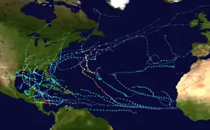
Hurricane Marco (2020)
Hurricane Marco was the first of two tropical cyclones to threaten the Gulf Coast of the United States within a three-day period, with the other being Hurricane Laura. The thirteenth named storm and third hurricane of the record-breaking 2020 Atlantic hurricane season, Marco developed from a fast-moving tropical wave west of the Windward Islands and south of Jamaica on August 20. The fast motion of the wave inhibited intensification initially, but as the wave slowed down and entered a more favorable environment, the system developed into a tropical depression, which in turn rapidly intensified into a strong tropical storm. Due to strong wind shear, Marco's intensification temporarily halted; however, after entering the warm waters of the Gulf of Mexico on August 23, Marco briefly intensified into a hurricane, only to quickly weaken later that evening due to another rapid increase in wind shear. Marco made landfall near the mouth of the Mississippi River on the evening of August 24, as a weak tropical storm and subsequently weakened to a tropical depression before becoming a remnant low early on the next morning. Marco's remnants subsequently dissipated on August 26.
| Category 1 hurricane (SSHWS/NWS) | |
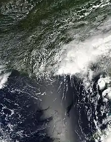
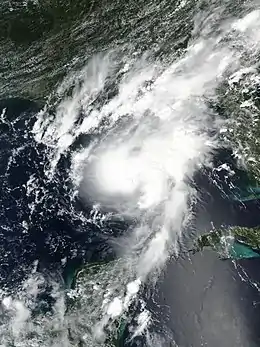 Hurricane Marco approaching Louisiana at peak intensity on August 23 | |
| Formed | August 20, 2020 |
|---|---|
| Dissipated | August 26, 2020 |
| (Remnant low after August 25) | |
| Highest winds | 1-minute sustained: 75 mph (120 km/h) |
| Lowest pressure | 991 mbar (hPa); 29.26 inHg |
| Fatalities | 1 total |
| Damage | ≥ $35 million (2020 USD) |
| Areas affected | Leeward Islands, Venezuela, Central America, Cayman Islands, Jamaica, Cuba, Yucatán Peninsula, Gulf Coast of the United States |
| Part of the 2020 Atlantic hurricane season | |
Heavy rains across the Yucatán Peninsula caused river rises and flooding throughout the region. One person was indirectly killed in Comitán, Mexico, due to the storm. Impacts in the United States were generally minor as the storm significantly weakened before landfall.
Meteorological history
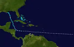
At 00:00 UTC on August 16, the National Hurricane Center (NHC) began monitoring a westward-moving tropical wave over the Central Atlantic that had the potential for development.[1] The disturbance quickly moved westward at a speed over 20 mph (32 km/h), which initially limited its development as it passed through the Windward Islands and into the Caribbean Sea. The system slowed down and gradually organized south of the Greater Antilles on August 19.[2] By 15:00 UTC on August 20, satellite imagery revealed that the wave had developed a well defined low-level center, prompting the NHC to designate it Tropical Depression Fourteen.[3] At the time the system was located 235 miles (378 km) east of the Nicaragua–Honduras border.[3] The storm continued westward toward Honduras, before making a sharp turn northward. Despite favorable conditions, the storm initially failed to intensify, with pulsing convection around a poorly defined center. Eventually, the storm's center became better defined and a small, but persistent cluster of convection formed over it. This allowed the depression to intensify, and the NHC upgraded the system to Tropical Storm Marco in the northwest Caribbean at 03:00 UTC on August 22. This was the earliest 13th named storm ever recorded in the Atlantic basin, breaking the record set by Maria of 2005 by 11 days.[4][5]
Soon after being named, Marco continued to contradict the forecasts and followed a more northerly course. Being a small system, Marco was able to quickly strengthen, reaching its initial peak intensity of 65 mph (105 km/h) and 992 mbar (29.3 inHg) just 12 hours after being named, with an almost closed eyewall being observed by Hurricane Hunters.[6][7] Contrary to prior predictions, Marco's track was shifted eastward at the 21:00 EDT advisory on August 22, as the system moved north-northeastward instead of north-northwestward, introducing the possibility of successive landfalls around Louisiana from both Laura and Marco.[7][8] An increase of southwesterly wind shear brought an abrupt end to the strengthening trend, as Marco moved through the Yucatán Channel, with the storm's minimum central pressure rising slightly and the eyewall mostly dissipating as the storm took on a sheared appearance.[9] This weakening period proved to be short-lived, as the shear relaxed somewhat when Marco moved into the warm waters of the Gulf of Mexico on August 23. Slow, but steady strengthening resumed and data from another Hurricane Hunter reconnaissance aircraft discovered sustained winds at hurricane strength in the northeastern eyewall. Subsequently, an update from the NHC confirmed that Marco had intensified into a Category 1 hurricane at 16:30 UTC on August 23.[10] It then reached its peak intensity at 21:00 UTC, with 1-minute sustained winds of 75 mph (120 km/h) and a minimum central pressure of 991 mbar (29.3 inHg).[11]
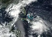
This strengthening proved to be short-lived, however, as upper-level wind shear increased again over the storm.[11] This caused Marco to weaken back to a tropical storm by 03:00 UTC on August 24, and the center of circulation became displaced from the storm's convection.[12] Relentless wind shear continued to plague the system as it turned westward near the Louisiana coastline, and Marco rapidly weakened to minimal tropical storm strength by 18:00 UTC.[13] At 23:00 UTC on August 24, Marco made landfall near the mouth of the Mississippi River, with 1-minute sustained winds at 40 mph (65 km/h) and a central pressure of 1,006 mbar (29.7 inHg), although the strongest winds were displaced in convection that was over waters well northeast of the center.[14] Afterward, Marco weakened further and fell to tropical depression intensity just offshore of Louisiana, near Grand Isle, at 03:00 UTC on August 25, before degenerating into a remnant low six hours later.[15][16] The remnant low continued to spin down as it slowly moved westward along the Louisiana coastline, ahead of the approaching Hurricane Laura, before opening up into a trough at 06:00 UTC on the next day.[17][18]
Preparations
Honduras issued tropical storm watches along its coastline when Tropical Depression Fourteen was designated, before quickly upgrading to warnings just hours later. Tropical Storm Watches, and later Tropical Storm Warnings and Hurricane Watches, were also issued for the eastern side of the Yucatán Peninsula, as the storm was first predicted to move over the peninsula as a strong tropical storm. When Marco moved to the north instead of northwest, a Tropical Storm Warning was issued by the Government of Cuba for the Pinar del Río Province and the Isle of Youth.[19][20]
Tropical Storm, Hurricane, and Storm Surge Watches were issued in Louisiana, Mississippi and Alabama when Marco's forecast track shifted significantly eastward on August 22. Many of these watches were upgraded to warnings as the storm continued its approach.[19] In Mississippi, mandatory evacuation orders were in place on August 23 at the Gulfport and Biloxi marinas and the harbor in Long Beach. All boats were ordered to be moved by sundown that same day. In Gulfport, the fuel dock was closed.[21] However, all the warnings were eventually downgraded and cancelled when the storm rapidly weakened as it approached the coast.[19] A tornado watch was issued for Far Southeast Alabama, the Florida Panhandle, Southwest Georgia, and the Coastal Waters at 20:40 UTC on August 24.[22]
Impacts
.gif)
Latin America and Cayman Islands
The Instituto Meteorológico Nacional of Costa Rica reported that heavy rain from the indirect effects of Marco affected parts of the country for three days. In Santa Cruz, Guanacaste Province, accumulations reached 17.0 in (431 mm); this was more than twice the average August rainfall of 9.1 in (231 mm). Areas in and around Santa Cruz reported flooding.[23]Moderate to heavy rains also caused some flooding in low-lying areas also some gusty winds at times in the Grand Cayman of the Cayman Islands.
In Mexico, the state of Chiapas was one of the areas hit hardest by Marco. One person was killed in Comitán and, following a landslide in Bochil, soldiers from the VII Military Region worked for several hours to enable the passage of vehicles to the city, with the help of Civil Protection personnel. In some municipalities of Chiapas, such as Tapachula, Escuintla and Acacoyagua, there was flooding due to the growth of rivers that come from mountains nearby.[24]
While traversing the Yucatán Channel, Marco brought heavy rain to parts of Pinar del Río Province in Cuba on August 23. The town of Isabel Rubio saw the greatest accumulations at 3.8 in (97 mm).[25] Minor flooding occurred in Mantua and Sandino. A few trees were downed during the storm.[26]
United States
Due to the sheared nature of the storm as it came ashore in the United States, rain bands extended as far northeast as Virginia. A tornado warning was issued for a storm just northeast of Panama City, Florida. Another tornado warning was issued for a storm near Charleston, South Carolina.[27] Numerous special marine warnings were also issued due to possible waterspouts.[28] However, no tornadoes or waterspouts were confirmed. Rainfall totals were highest along the Florida Panhandle, peaking at 11.81 inches (300 mm) near Apalachicola on Monday morning. Several roadways were flooded in Panama City Beach that evening as well.[29] However, heavy rainfall extended much further inland with flash flood warnings being issued as far northeast as the North Carolina—Virginia border.[30] Due to Marco being much weaker than anticipated, no wind damage occurred and the peak wind gust from the storm was only 38 mph (61 km/h), which was recorded in Petit Bois Island, Mississippi.[29] The remnants of the storm brought heavy rainfall and flash flooding to Southeastern Oklahoma on August 26 before dissipating.[31] Overall, Marco caused at least $35 million USD in damages throughout the impacted areas.[32]
See also
- Tropical cyclones in 2020
- Other storms of the same name
- List of Category 1 Atlantic hurricanes
- Tropical Storm Arlene (2005) – a similar storm that affected similar areas
- Hurricane Cindy (2005) – a storm that had a similar track
- Hurricane Nate (2017) – also caused flooding in Central America and Cuba
- Tropical Storm Alberto (2018) – a storm that affected similar areas
References
- Stacy Stewart (August 16, 2020). "Five-Day Graphical Tropical Weather Outlook". www.nhc.noaa.gov. Miami, Florida: National Hurricane Center. Retrieved August 20, 2020.
- Andrew Latto (August 19, 2020). "Five-Day Graphical Tropical Weather Outlook". www.nhc.noaa.gov. Miami, Florida: National Hurricane Center. Retrieved August 20, 2020.
- Robbie Berg (August 20, 2020). "Tropical Depression Fourteen Public Advisory Number 1". www.nhc.noaa.gov. Miami, Florida: National Hurricane Center. Retrieved August 20, 2020.
- David Zelinsky (August 22, 2020). "Tropical Storm Marco Discussion Number 7". www.nhc.noaa.gov. Miami, Florida: National Hurricane Center. Retrieved August 23, 2020.
- Kimberly Miller, Doyle Rice (August 21, 2020). "Two Gulf hurricanes at the same time? Tropical Storm Laura has formed". www.usatoday.com. Retrieved August 21, 2020.
- Robbie Berg (August 22, 2020). "Tropical Storm Marco Discussion Number 9". www.nhc.noaa.gov. Miami, Florida: National Hurricane Center. Retrieved August 24, 2020.
- Robbie Berg (August 22, 2020). "Tropical Storm Marco Discussion Number 10". www.nhc.noaa.gov. Miami, Florida: National Hurricane Center. Retrieved August 22, 2020.
- Jonathan Erdman (August 22, 2020). "Tropical Storms Laura and Marco Could Deliver Back-to-Back Landfalls on U.S. Gulf Coast; Here's How Rare That Is". weather.com. The Weather Company. Retrieved August 22, 2020.
- David Zelinsky (August 23, 2020). "Tropical Storm Marco Discussion Number 11". www.nhc.noaa.gov. Miami, Florida: National Hurricane Center. Retrieved August 24, 2020.
- Andrew Latto (August 23, 2020). "Hurricane Marco Tropical Cyclone Update". www.nhc.noaa.gov. Miami, Florida: National Hurricane Center. Retrieved August 23, 2020.
- Andrew Latto (August 23, 2020). "Hurricane Marco Discussion Number 14". www.nhc.noaa.gov. Miami, Florida: National Hurricane Center. Retrieved August 24, 2020.
- David Zelinsky (August 24, 2020). "Hurricane Marco Discussion Number 15". www.nhc.noaa.gov. Miami, Florida: National Hurricane Center. Retrieved August 24, 2020.
- Andrew Latto (August 24, 2020). "Tropical Storm Marco Special Discussion Number 18". www.nhc.noaa.gov. Miami, Florida: National Hurricane Center. Retrieved August 27, 2020.
- David Zelinsky (August 24, 2020). "Tropical Storm Marco Tropical Cyclone Update". www.nhc.noaa.gov. Miami, Florida: National Hurricane Center. Retrieved August 27, 2020.
- David Zelinsky (August 25, 2020). "Tropical Depression Marco Discussion Number 20". www.nhc.noaa.gov. Miami, Florida: National Hurricane Center. Retrieved August 27, 2020.
- Stacy R. Stewart (August 25, 2020). "Post-Tropical Cyclone Marco Discussion Number 21". www.nhc.noaa.gov. Retrieved August 27, 2020.
- "WPC Surface Analysis valid for 08/26/2020 at 00 UTC". wpc.ncep.noaa.gov. Weather Prediction Center. August 26, 2020. Retrieved August 26, 2020.
- "WPC Surface Analysis valid for 08/26/2020 at 06 UTC". wpc.ncep.noaa.gov. Weather Prediction Center. August 26, 2020. Retrieved August 26, 2020.
- "Hurricane Marco Advisory Archive". www.nhc.noaa.gov. Miami, Florida: National Hurricane Center. 2020. Retrieved August 24, 2020.
- "Hurricane Marco, Tropical Storm Laura form dual threat to Gulf Coast; Florida Keys under tropical storm watch". orlandosentinel.com. Orlando Sentinel. August 23, 2020. Retrieved August 23, 2020.
- "Marco downgraded to tropical storm as Laura intensifies near Cuba". sunherald.com. Sun Herald. August 23, 2020. Retrieved August 24, 2020.
- "Storm Prediction Center Tornado Watch 448". www.spc.noaa.gov. Retrieved August 24, 2020.
- Hugo Solano (August 24, 2020). "Afectación por tormenta Marco dejó en tres días en Santa Cruz más del doble de la lluvia que cae en todo el mes". La Nación (in Spanish). Retrieved August 24, 2020.
- Fredy Martín Pérez (August 23, 2020). "Muere niña en Chiapas por afectaciones de la tormenta tropical "Marco"". El Universal. Retrieved August 23, 2020.
- ""Laura" afecta con lluvias a Dominicana y "Marco" avanza por el Golfo de México". Vanguardia (in Spanish). Institute of Meteorology of the Republic of Cuba. August 23, 2020. Retrieved August 24, 2020.
- "Tormenta Marco deja inundaciones en Pinar del Río". Periódico Cubano (in Spanish). August 23, 2020. Retrieved August 24, 2020.
- akrherz@iastate.edu, daryl herzmann. "IEM :: Storm Based Warning Polygon Visual Summary". mesonet.agron.iastate.edu. Retrieved August 24, 2020.
- akrherz@iastate.edu, daryl herzmann. "IEM :: Storm Based Warning Polygon Visual Summary". mesonet.agron.iastate.edu. Retrieved August 24, 2020.
- "Marco Weakens and May Still Bring Heavy Rain to Parts of Gulf Coast Into Tuesday". The Weather Channel. Retrieved August 25, 2020.
- akrherz@iastate.edu, daryl herzmann. "IEM :: Storm Based Warning Polygon Visual Summary". mesonet.agron.iastate.edu. Retrieved August 24, 2020.
- akrherz@iastate.edu, daryl herzmann. "IEM :: Storm Based Warning Polygon Visual Summary". mesonet.agron.iastate.edu. Retrieved August 30, 2020.
- "Global Catastrophe Recap September 2020" (PDF). Aon. October 8, 2020. Archived (PDF) from the original on October 8, 2020. Retrieved October 8, 2020.
External links
| Wikimedia Commons has media related to Hurricane Marco (2020). |
- The National Hurricane Center's Advisory Archive on Hurricane Marco
- National Hurricane Center (NHC)
- Weather Prediction Center (WPC)
