Hyndburn
Hyndburn /ˈhaɪndbərn/ is a local government district with borough status in Lancashire, England. Its council is based in Accrington. The borough, which takes its name from the River Hyndburn, had a population of 80,734 at the 2011 Census.[1]
Borough of Hyndburn | |
|---|---|
Borough | |
 Coat of Arms | |
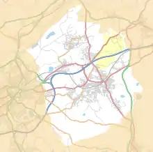
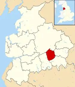 Shown within Lancashire and England | |
| Sovereign state | United Kingdom |
| Constituent country | England |
| Region | North West England |
| Ceremonial county | Lancashire |
| Founded | 1974 |
| Admin. HQ | Accrington |
| Government | |
| • Type | Hyndburn Borough Council |
| • Leadership: | Leader & Cabinet |
| • MPs: | Sara Britcliffe |
| Area | |
| • Total | 28.19 sq mi (73.00 km2) |
| Area rank | 247th |
| Population (mid-2019 est.) | |
| • Total | 81,043 |
| • Rank | Ranked 286th |
| • Density | 2,900/sq mi (1,100/km2) |
| Time zone | UTC+0 (Greenwich Mean Time) |
| • Summer (DST) | UTC+1 (British Summer Time) |
| Postcode | BB1, BB5, BB6 |
| Area code(s) | 01254 |
| ONS code | 30UG (ONS) E07000120 (GSS) |
| Ethnicity | 80.7% White 11.2% Asian 1.2% Other[1] |
| Website | hyndburnbc.gov.uk |
It was formed in 1974, by the amalgamation of the Borough of Accrington, the Urban Districts of Church, Clayton-le-Moors, Great Harwood, Oswaldtwistle /ˈɒzəl.twɪzəl/ and Rishton, and part of the Burnley Rural District.
In March 2010, Hyndburn was voted the 10th best council in The Times "Best Public Sector Places to Work".[2] The borough also made it to The Times Best Companies Guide.
Rename
In June 2007, the council proposed changing the name of Hyndburn, and replace it with Accrington & Districts, to aid recognition of the borough by those not familiar with the area.[3] In December 2007, after a public consultation, the plans were stalled.[4] In May 2008, however, this plan was shelved.
Education
There are approximately nine state secondary schools in Hyndburn. These include The Hyndburn Academy, St Christopher's Church of England High School, Accrington Academy, Rhyddings Business and Enterprise School, Mount Carmel Roman Catholic High School, The Hollins, along with Broadfield Specialist School, and North Cliffe School.[5]
The Percentage of pupils achieving 5 or more GCSEs at grades A*-C has increased from 43.7% in 2001 up to 75.9% in 2011. Absences has dropped from 12,052 in 2006 to 9,545 in 2011, mainly due to schools competing.[6]
Geography
The district is polycentric and is located between the larger settlements of Blackburn and Burnley. It is linked to both areas by the M65 motorway and the East Lancashire railway line.
Places in Hyndburn
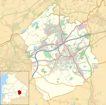
- Accrington
- Altham
- Baxenden
- Belthorn (part)
- Church
- Clayton-le-Moors
- Great Harwood
- Huncoat
- Knuzden (considered a suburb of Blackburn)
- Oswaldtwistle
- Rishton
- Tottleworth
- Whitebirk (part) (considered a suburb of Blackburn)
Neighbouring districts
Neighbouring Districts | |
|---|---|
Freedom of the Borough
The following people and military units have received the Freedom of the Borough of Hyndburn.
Individuals
- Ronald Hill MBE: 10 July 2012. [7]
- Julie Hesmondhalgh: 28 January 2015. [8]
- David Lloyd: 6 July 2018.
- Councillor Bernard Dawson: 6 July 2018.
References
- UK Census (2011). "Local Area Report – Hyndburn Local Authority (E07000120)". Nomis. Office for National Statistics. Retrieved 11 May 2019.
- "Hyndburn Council in top 75 places to work". lancashiretelegraph.co.uk. March 18, 2010. Retrieved June 2, 2015.
- "Should it be Hyndburn or Accrington?". lancashiretelegraph.co.uk. June 1, 2007. Retrieved June 2, 2015.
- "Name change bid on ice". lancashiretelegraph.co.uk. December 4, 2007. Retrieved June 2, 2015.
- http://www.hyndburnbc.gov.uk/site/scripts/services_info.php?serviceID=243
- "Archived copy". Archived from the original on 2010-04-13. Retrieved 2011-03-06.CS1 maint: archived copy as title (link)
- https://www.bbc.com/news/uk-england-lancashire-18772353
- https://www.bbc.com/news/uk-england-lancashire-31021485
- https://www.lancs.live/news/cricket-star-david-lloyd-bernard-14876451
- https://www.warmemorialsonline.org.uk/memorial/206138
External links
- Accrington Web Hyndburn's local community forum
- Civic Arts Centre Listings for what's on at the Civic Arts Centre