In Amguel
In Amguel (Arabic: عين امقل, lit. Amguel spring) is a town and commune in Tamanrasset District, Tamanrasset Province, Algeria. According to the 2008 census it has a population of 4,208,[1] up from 3,030 in 1998,[2] with an annual growth rate of 3.4%.[1] Its postal code is 11100 and its municipal code is 1109.
In Amguel
عين امقل | |
|---|---|
Commune and town | |
 | |
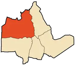 Location of In Amguel commune within Tamanrasset Province | |
 In Amguel Location of In Amguel within Algeria | |
| Coordinates: 23°41′37″N 5°9′53″E | |
| Country | |
| Province | Tamanrasset Province |
| District | Tamanrasset District |
| Area | |
| • Total | 93,438 km2 (36,077 sq mi) |
| Elevation | 1,026 m (3,366 ft) |
| Population (2008)[1] | |
| • Total | 4,208 |
| • Density | 0.045/km2 (0.12/sq mi) |
| Time zone | UTC+1 (CET) |
| PMA seats (as of 2007) | 7 |
| ONS code | 1109 |
| Postal code | 11100 |
Geography
In Amguel lies at an elevation of 981 metres (3,219 ft) on the southern bank of a wadi that cuts through a plateau lying to the northwest of the Hoggar Mountains. The numerous wadis in the area support some vegetation, but beyond them the land is barren and rocky.
In Amguel will be remembered for was the scene of several underground Nuclear Tests conducted by the French military. They included the now infamous Béryl incident which released a cloud of radioactive dust outside the tunnel entrance, contaminating officials viewing the test.
Climate
In Amguel has a hot desert climate (Köppen climate classification BWh), with very hot summers and mild winters, and very little precipitation throughout the year.
| Climate data for In Amguel | |||||||||||||
|---|---|---|---|---|---|---|---|---|---|---|---|---|---|
| Month | Jan | Feb | Mar | Apr | May | Jun | Jul | Aug | Sep | Oct | Nov | Dec | Year |
| Average high °C (°F) | 20.8 (69.4) |
23.4 (74.1) |
27.2 (81.0) |
31.8 (89.2) |
35.4 (95.7) |
38.1 (100.6) |
38.3 (100.9) |
37.5 (99.5) |
35.8 (96.4) |
31.8 (89.2) |
27.2 (81.0) |
22.5 (72.5) |
30.8 (87.5) |
| Daily mean °C (°F) | 13.1 (55.6) |
15.4 (59.7) |
19.0 (66.2) |
23.6 (74.5) |
27.6 (81.7) |
31.0 (87.8) |
31.3 (88.3) |
30.7 (87.3) |
28.8 (83.8) |
24.5 (76.1) |
19.6 (67.3) |
15.0 (59.0) |
23.3 (73.9) |
| Average low °C (°F) | 5.5 (41.9) |
7.5 (45.5) |
10.9 (51.6) |
15.5 (59.9) |
19.8 (67.6) |
23.9 (75.0) |
24.4 (75.9) |
24.0 (75.2) |
21.8 (71.2) |
17.3 (63.1) |
12.1 (53.8) |
7.5 (45.5) |
15.9 (60.5) |
| Average precipitation mm (inches) | 1 (0.0) |
1 (0.0) |
2 (0.1) |
1 (0.0) |
3 (0.1) |
3 (0.1) |
2 (0.1) |
5 (0.2) |
5 (0.2) |
2 (0.1) |
1 (0.0) |
2 (0.1) |
28 (1) |
| Source: climate-data.org[3] | |||||||||||||
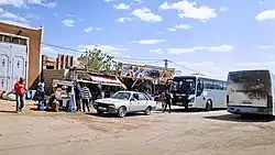
Transportation
In Amguel is located on the N1 national highway, leading north to In Salah and south to Tamanrasset. Just to the south of the town, the N55 branches from the N1, leading to Bordj El Houasse.
Education
4.2% of the population has a tertiary education, and another 11.4% has completed secondary education.[4] The overall literacy rate is 71.1%, and is 77.7% among males and 63.8% among females.[5]
Localities
The commune is composed of eight localities:[6]
References
- "Population: Wilaya de Tamanrasset" (PDF) (in French). Office National des Statistiques Algérie. Archived from the original (PDF) on 13 November 2011. Retrieved 30 May 2013.
- "Algeria Communes". Statoids. Retrieved 8 March 2013.
- "Climate data for: In Amguel". climate-data.org. Retrieved 30 May 2013.
- "Structure relative de la population résidente des ménages ordinaires et collectifs âgée de 6 ans et plus selon le niveau d'instruction et la commune de résidence" (PDF) (in French). Office National des Statistiques Algérie. Archived from the original (PDF) on 13 November 2011. Retrieved 30 May 2013.
- "Taux d'analphabétisme et taux d'alphabétisation de la population âgée de 15 ans et plus, selon le sexe et la commune de résidence " (PDF) (in French). Office National des Statistiques Algérie. Archived from the original (PDF) on 13 November 2011. Retrieved 30 May 2013.
- "Décret n° 84-365, fixant la composition, la consistance et les limites territoriale des communes. Wilaya de Tamanghasset" (PDF) (in French). Journal officiel de la République Algérienne. 19 December 1984. p. 1496. Archived from the original (PDF) on 5 May 2015. Retrieved 2 March 2013.
Places adjacent to In Amguel | |
|---|---|
| Tamanrasset District | .svg.png.webp) | |||||
|---|---|---|---|---|---|---|
| In Salah District | ||||||
| Tazrouk District | ||||||
| Abalessa District | ||||||
| In Ghar District | ||||||
| Tin Zaouatine District | ||||||
| In Guezzam District | ||||||