International Boundary Marker No. 1, U.S. and Mexico
International Boundary Marker No. 1, U.S. and Mexico is a monument on the Mexico–U.S. border, on the west bank of the Rio Grande River near El Paso, Texas. It was listed on the National Register of Historic Places in 1974.[1]
International Boundary Marker No. 1, U.S. and Mexico | |
 | |
 | |
| Nearest city | El Paso, Texas |
|---|---|
| Coordinates | 31.783889°N 106.529755°W |
| Area | 0.1 acres (0.040 ha) |
| Built | 1855 |
| Built by | Emory-Salazar Commission |
| NRHP reference No. | 74001195[1] |
| Added to NRHP | September 10, 1974 |
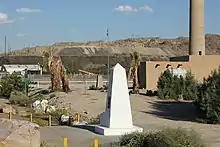
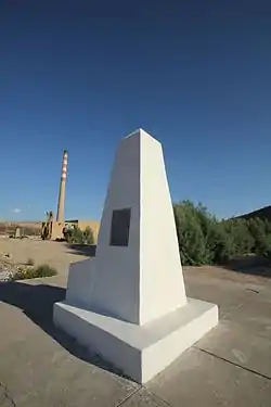
The monument was placed there in 1855 by the Emory-Salazar Commission. It is a dressed cut stone monument 12 feet (3.7 m) tall, 5 by 5 feet (1.5 m × 1.5 m) at its base and 2.5 by 2.5 feet (0.76 m × 0.76 m) at its top. The monument was repaired in 1892 by the Barlow-Blanco Commission, and again in 1929 by the International Boundary Commission. It was repainted in 1933 and in 1959, the latter time by the International Boundary and Water Commission (IBWC). It was refurbished in 1966 by both sections of the IBWC, which stripped its old plaster coating down to the original masonry monument and re-faced it with white marbleized concrete. A 9 by 9 metres (30 ft × 30 ft) concrete slab platform was added then, too.[2]
It has also been known as Western Land Boundary Marker No. 1, U.S. and Mexico.
It is located in Doña Ana County, New Mexico, west of El Paso off Interstate 10.
References
- "National Register Information System". National Register of Historic Places. National Park Service. November 2, 2013.
- Morris H. Raney (1974). "National Register of Historic Places Inventory/Nomination: International Boundary Marker No. 1, U.S. and Mexico / Western Land Boundary Marker No. 1, U.S. and Mexico". National Park Service. Retrieved February 6, 2019. With accompanying photo from 1973
| Topics | |
|---|---|
| Lists by state |
|
| Lists by insular areas | |
| Lists by associated state | |
| Other areas | |
| Related | |
| |