Interstate 180 (Illinois)
Interstate 180 (I-180) is a north–south spur highway that runs from Princeton, Illinois to the small town of Hennepin, Illinois on its southern terminus. It is 13.19 miles (21.23 km) long.[3]
| ||||
|---|---|---|---|---|
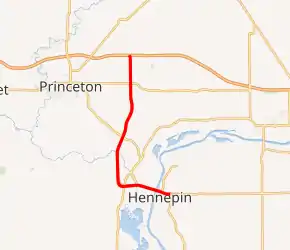
I-180 highlighted in red | ||||
| Route information | ||||
| Auxiliary route of I-80 | ||||
| Maintained by IDOT | ||||
| Length | 13.19 mi[1] (21.23 km) | |||
| Existed | 1967–present | |||
| History | Completed in 1969[2] | |||
| Major junctions | ||||
| South end | ||||
| North end | ||||
| Location | ||||
| Counties | Putnam, Bureau | |||
| Highway system | ||||
| ||||

Route description
Interstate 180 begins as a continuation of Route 71 at a diamond interchange with Route 26 northeast of Hennepin. The interchange is located adjacent to a former steel mill that was most recently operated by ArcelorMittal until 2009.[4] The freeway travels northwest, carrying I-180 and Route 26 in a concurrency, and crosses the Illinois River on the north side of Hennepin to enter Bureau County.[1]
On the west side of the river, Route 26 separates from I-180 and the freeway crosses over Route 29 before splitting at a Y-interchange. I-180 turns north, intersecting an expressway that connects to Route 29, and travels northeast across Big Bureau Creek to intersect Route 26. The freeway intersects U.S. Route 6 east of Princeton and continues due north to its terminus, a trumpet interchange with I-80. I-180 has four lanes for its entire length.[1]
History
Construction of I-180 was completed in 1969.[2] The freeway was built primarily to connect Interstate 80 to a new Jones & Laughlin steel plant built in 1965 in Hennepin, IL.[5] However, the steel plant closed soon after I-180 was built, and did not re-open until August 2002. Federal auditors criticized its construction and called it a political favor that was put ahead of other requests from Tucson, Arizona and Tacoma, Washington.[6]
I-180 is one of the least traveled interstates in the nation, serving 1,950–3,600 vehicles per day as of 2013.[7]
Exit list
| County | Location | mi | km | Exit | Destinations | Notes |
|---|---|---|---|---|---|---|
| Putnam | Hennepin | 0.00 | 0.00 | Continues beyond southern terminus | ||
| 14 | South end of IL 26 concurrency | |||||
| Illinois River | 1.0 | 1.6 | Gudmund "Sonny" Jessen Bridge | |||
| Bureau | Bureau Junction | 2.5 | 4.0 | 12 | North end of IL 26 concurrency; northbound exit and southbound entrance | |
| 3.5 | 5.6 | — | Access via unnamed connector expressway | |||
| 8.0 | 12.9 | 7 | ||||
| Princeton | 12.0 | 19.3 | 3 | |||
| 13.2 | 21.2 | — | Northern terminus; I-80 exit 61 | |||
1.000 mi = 1.609 km; 1.000 km = 0.621 mi
| ||||||
References
- Google (September 29, 2019). "Interstate 180" (Map). Google Maps. Google. Retrieved September 29, 2019.
- Scott, Tony (December 21, 2006). "Strong opinions on Prairie Parkway plans". Oswego Ledger-Sentinel. Archived from the original on December 28, 2010. Retrieved February 15, 2008.
- United States Department of Transportation - Federal Highway Administration (October 31, 2002). "Route Log - Auxiliary Routes of the Eisenhower National System Of Interstate and Defense Highways". Retrieved January 30, 2007.
- Smith, Gary L. (April 19, 2017). "Shuttered Hennepin steel mill being demolished". Journal Star. Peoria, Illinois. Retrieved September 29, 2019.
- "Boom Town 1965". Time. July 9, 1965. Retrieved July 9, 2012.
- Polk, James R. (August 4, 1970). "Federal Auditors Criticize a $40-Million Interstate Highway Spur to Illinois Steel Plant". Capital Journal. p. 26. Retrieved July 10, 2018 – via Newspapers.com.

- Illinois Department of Transportation (2013). "T2 GIS Data". Archived from the original on March 2, 2016. Retrieved February 24, 2016.
External links
| Wikimedia Commons has media related to Interstate 180 (Illinois). |
- Kurumi's Roads Page -- Interstate 180
- Illinois Highway Ends - I-180
- Roads of the Mid-South and West: Interstate 180
| ||
| ||