Interstate 238
Interstate 238 (I-238) is an auxiliary Interstate Highway in the San Francisco Bay Area in the U.S. state of California. It comprises the northernmost 2.126 miles (3.421 km) of Route 238, as defined by the California Streets and Highways Code. Originally signed as State Route 238 (SR 238) until 1983, it connects I-580 in Castro Valley (where SR 238 continues south) with I-880 in San Leandro.
| ||||
|---|---|---|---|---|

I-238 highlighted in red | ||||
| Route information | ||||
| Defined by Streets and Highways Code § 538 | ||||
| Maintained by Caltrans | ||||
| Length | 2.126 mi[1][2] (3.421 km) | |||
| Existed | May 1983 by FHWA[3]–present | |||
| Major junctions | ||||
| South end | ||||
| North end | ||||
| Location | ||||
| Counties | Alameda | |||
| Highway system | ||||
| ||||
.svg.png.webp)
The numbering of I-238 does not fit within the usual conventions of existing three-digit auxiliary Interstate Highways, where a single digit is prefixed to the two-digit number of its parent Interstate Highway, because I-38 does not exist. The I-238 number was specifically requested by the State of California so it could match the California Streets and Highways Code and because all three-digit combinations of I-80 (the primary two-digit Interstate in the Bay Area) were already being used in the state.
Route description
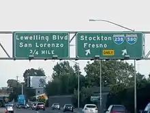
Although the 2.16-mile-long (3.48 km) I-238 goes in an east–west direction from Castro Valley to San Leandro, Caltrans officially signs it as a north–south freeway since the rest of SR 238 is more north–south. The southern (geographically eastern) terminus of I-238 is at its interchange with I-580 and SR 238 in Castro Valley. From there, it enters into the southern portion of the census-designated place of Ashland, running parallel to its border with Cherryland. Then after entering San Leandro, I-238 ends at its northern (geographically western) terminus with I-880.
I-238 is part of the California Freeway and Expressway System,[4] and is part of the National Highway System,[5] a network of highways that are considered essential to the country's economy, defense, and mobility by the Federal Highway Administration.[6] I-238 and I-880 are used as an alternate truck route between Castro Valley and Oakland; trucks over 4.5 short tons (4.1 t) are prohibited through the latter on I-580.[7]
Numbering
The number does not follow established rules for numbering Interstates, as there is no Interstate 38. As it connects two auxiliary routes of I-80, it would normally use a three-digit number ending in 80, but of the nine possible numbers, two (180 and 480) were in use by State Routes (the latter an Interstate until 1968 though SR 480 was deleted in 1991), and the remainder were already in use by other California auxiliary routes. (I-880 was designated at the same time as I-238.)
History
The section of road that is now I-238 had no signed number before the 1964 renumbering; it was pre-1964 Legislative Route 228 (along with an unbuilt extension west to unbuilt SR 61, which is still included in the SR 238 definition).
The segment from what is now I-580 to I-880 was built as a freeway in 1956.[2] The rest of SR 238 south to I-680 in Fremont was also planned to be upgraded to a freeway (parallel to present I-880), but after it was unsuccessfully submitted to the Interstate Highway System in October 1968,[3] and after several lawsuits, it was cancelled in 2003.[8]
When present, I-880 was added to the Interstate Highway System as a renumbering of part of SR 17, the short piece of SR 238 connecting I-880 to I-580 was also added; both were non-chargeable routes (not eligible for Interstate Completion funds). Both numbers—I-238 and I-880—were approved by the American Association of State Highway and Transportation Officials (AASHTO) on July 7, 1983.[3] The interchanges with I-580 and I-880 were rebuilt from 1988 to 1994, in part to add missing ramps between I-238 and I-880 towards the south.[2] Prior to the completion of the ramps, access was provided by Hesperian Boulevard.
On July 7, 1983, while approving the designation, AASHTO said:
This is to inform you that your application for the elimination of Route 180 and extension of Route 580, and the establishment of Route 880 and Route 238 have been approved.
However, since the I-238 designation does not fit the overall national numbering sequence and was necessitated only because all three [-digit] combinations of I-80 have been used, the Committee has a further option to offer for your consideration. If the I-580 designation [were] continued from Castro Valley to San Lorenzo and then used in place of the proposed I-880 designation northerly to Oakland and over existing I-180 between Albany and San Rafael, then existing I-580 between Castro Valley and Oakland could be designated I-180. The Committee does recognize this option would involve considerable resigning, however.
On July 27, 1983, Caltrans responded:
We already have a State Route 180 in our Fresno area, and this route is separated from I-580 in Castro Valley by about 100 miles [160 km]. We are therefore unable to recommend the designation of existing I-580 between Castro Valley and Oakland as I-180.[9]
With the decommissioning of SR 480 in 1991, the "480" designation was once again made available. However, there has been no push since then to renumber I-238 to I-480.
In September 2006, a project began to reconstruct the entire length of I-238, including a reconfigured interchange with I-880 and an added travel lane in each direction. Additionally, almost all of the bridges and overpasses were replaced with new ones meeting current earthquake resistance standards. The project was completed in October 2009, six months ahead of schedule.[10]
Exit list
Mileage is based on the rest of SR 238. The entire route is in Alameda County.
| Location | mi[11] | km | Exit[11] | Destinations | Notes |
|---|---|---|---|---|---|
| Castro Valley | 14.47 | 23.29 | — | South end of I-238; continuation beyond I-580 | |
| 14 | Left southbound exit and northbound entrance; I-580 exit 34 | ||||
| Ashland | 14.93 | 24.03 | 15 | Northbound signage omits Mission Blvd. despite the name change when SR 185 cross I-238 | |
| San Leandro | 16.03 | 25.80 | 16A | Northbound exit and southbound entrance; I-880 north exit 31A | |
| 16.28 | 26.20 | 16B | Hesperian Boulevard – San Lorenzo | Northbound exit and southbound entrance | |
| 16.68 | 26.84 | 17A | Washington Avenue | Northbound exit and southbound entrance | |
| 16.70 | 26.88 | 17B | Northbound exit and southbound entrance; north end of I-238; I-880 south exit 31 | ||
| 1.000 mi = 1.609 km; 1.000 km = 0.621 mi | |||||
See also
 California Roads portal
 San Francisco Bay Area portal
References
- California Department of Transportation. "State Truck Route List". Sacramento: California Department of Transportation. Archived from the original (XLS file) on June 30, 2015. Retrieved June 30, 2015.
- California Department of Transportation (July 2007). "Log of Bridges on State Highways". Sacramento: California Department of Transportation.
- Faigin, Daniel P. (December 25, 2013). "Interstate Highway Types and the History of California's Interstates". California Highways. Self=published. Retrieved December 25, 2013.
- "Article 2 of Chapter 2 of Division 1". California Streets and Highways Code. Sacramento: California Office of Legislative Counsel. Retrieved February 6, 2019.
- Federal Highway Administration (March 25, 2015). National Highway System: San Francisco, CA (PDF) (Map). Scale not given. Washington, DC: Federal Highway Administration. Retrieved September 4, 2017.
- Natzke, Stefan; Neathery, Mike & Adderly, Kevin (June 20, 2012). "What is the National Highway System?". National Highway System. Washington, DC: Federal Highway Administration. Retrieved July 1, 2012.
- "California Interstate Route 580 Special Restriction History". California Department of Transportation. Retrieved April 7, 2011.
- Faigin, Daniel P. "Routes 233 through 240". California Highways. Self-published. Retrieved January 26, 2013.
- Casey. "Indigestion 238". Casey's Roads and Highways Page. Retrieved January 26, 2013.
- Moore-Lewis, Phyllis (October 29, 2009). "Caltrans Celebrates Widening of Interstate 238 With Ribbon-Cutting Ceremony" (PDF) (Press release). California Department of Transportation. Retrieved September 14, 2012.
- "Interstate 238 Freeway Interchanges" (PDF). California Numbered Exit Uniform System. California Department of Transportation. October 19, 2018. Retrieved October 17, 2020.
External links
| Wikimedia Commons has media related to Interstate 238. |
- Indigestion 238: A history of the route and a full explanation of its numbering
- I-238 California: Kurumi
- California @ AARoads.com - Interstate 238
- Caltrans: Route 238 highway conditions
- California Highways: I-238
| ||
| ||
| Signed | |
|---|---|
| Unsigned | |
| Lists | |
| Other | |
Major Interstates highlighted | |