Kherlen River
Kherlen River (also known as Kern or Kerülen; Mongolian: Хэрлэн гол; Chinese: 克鲁伦河; pinyin: Kèlǔlún hé) is a river of 1,254 km length in Mongolia and China.[1]
| Kherlen River 克鲁伦河 (Kèlǔlún hé) | |
|---|---|
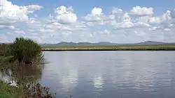 Near Ondorkhaan | |
 | |
| Etymology | Mongolian: kherlen, "hederated" |
| Native name | Хэрлэн гол |
| Location | |
| Country | Mongolia, People's Republic of China |
| Mongolian Aimags | Khentii, Dornod |
| Chinese Region | Inner Mongolia |
| Chinese Prefecture | Hulunbuir |
| Physical characteristics | |
| Source | |
| • location | Burkhan Khaldun, Khentii Mountains |
| Mouth | Hulun Nuur |
• coordinates | 48°44′N 117°5′E |
| Length | 1,254 km (779 mi) |
Course
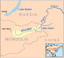
The river has its origin in the south slopes of the Khentii mountains, near the Burkhan Khaldun mountain in the Khan Khentii Strictly Protected Area, about 180 km northeast of Ulaanbaatar.[1] This area is the watershed between the arctic (Tuul River) and pacific (Kherlen, Onon) basins and named Three river basins.
From there the Kherlen flows in a mostly eastern direction through the Khentii aimag. On its further way it crosses the eastern Mongolian steppe past Ulaan Ereg and Choibalsan, entering China at 48°3′N 115°36′E, emptying into Hulun Nuur after another 164 km.
Kherlen-Ergune-Amur
In years with high precipitation, the normally exitless Hulun Lake may overflow at its northern shore, and the water will meet the Ergune River after about 30 km.[1] The Ergune marks the border between Russia and China for about 944 km, until it meets the Amur River. The system Kherlen-Ergune-Amur has a total length of 5,052 km.
See also
References
- Brutsaert, Wilfried; Sugita, Michiaki (December 2008). "Is Mongolia's groundwater increasing or decreasing? The case of the Kherlen River basin". Hydrological Sciences Journal. London: Taylor & Francis Informa Ltd. 53 (6): 1221–1229. doi:10.1623/hysj.53.6.1221. Retrieved 19 January 2015.