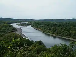
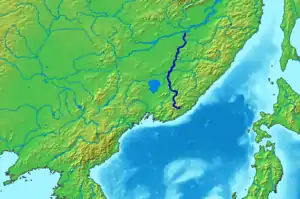
Ussuri
The Ussuri or Wusuli (Russian: Уссури; Chinese: 乌苏里江; pinyin: Wūsūlǐ Jiāng) runs through Khabarovsk and Primorsky Krais, Russia and the southeast region of Northeast China. It rises in the Sikhote-Alin mountain range, flowing north and forming part of the Sino-Russian border (which is based on the Sino-Russian Convention of Peking of 1860), until it joins the Amur as a tributary to it near Khabarovsk. It is approximately 897 kilometers (557 mi) long. The Ussuri drains the Ussuri basin, which covers 193,000 square kilometers (75,000 sq mi).[1] Its waters come from rain (60%), snow (30–35%), and subterranean springs. The average discharge is 1,150 cubic metres per second (41,000 cu ft/s), and the average elevation is 1,682 metres (5,518 ft).
| Ussuri | |
|---|---|
 | |
| Location | |
| Country | China, Russia |
| Physical characteristics | |
| Mouth | Amur |
• coordinates | 48.2666°N 134.7204°E |
| Length | 897 km (557 mi) |
| Basin size | 193,000 km2 (75,000 sq mi) |
| Basin features | |
| Progression | Amur→ Sea of Okhotsk |
| Ussuri | |||||||||
|---|---|---|---|---|---|---|---|---|---|
 | |||||||||
| Chinese name | |||||||||
| Traditional Chinese | 烏蘇里江 | ||||||||
| Simplified Chinese | 乌苏里江 | ||||||||
| |||||||||
| Manchu name | |||||||||
| Manchu script | ᡠᠰᡠᡵᡳ ᡠᠯᠠ | ||||||||
| Romanization | usuri ula | ||||||||
| Russian name | |||||||||
| Russian | река Уссури | ||||||||
| Romanization | reka Ussuri | ||||||||
Names
The Ussuri has been known by many names. In Manchu, it was called the Usuri Ula or Dobi Bira (River of Foxes) and in Mongolian the Üssüri Müren.[2]
History
- The Ussuri has a reputation for catastrophic floods. It freezes up in November and stays under the ice until April. The river teems with different kinds of fish: grayling, sturgeon, humpback salmon (gorbusha), chum salmon (keta), and others.
- During World War II, the river marked one of the boundaries which Soviet forces crossed into Manchuria in Operation August Storm in 1945.
- The Sino-Soviet border conflict of 1969 took place at the Soviet Damansky Island on the Ussuri River.
Tributaries
Major tributaries of the Ussuri are, from source to mouth:
- Arsenyevka (left)
- Sungacha (left)
- Muling (left)
- Bolshaya Ussurka (right)
- Bikin (right)
- Naoli (left)
- Khor (right)
See also
References
- Уссури, Great Soviet Encyclopedia
- Narangoa 2014, p. 299.
Sources
- Narangoa, Li (2014). Historical Atlas of Northeast Asia, 1590-2010: Korea, Manchuria, Mongolia, Eastern Siberia. New York: Columbia University Press. ISBN 9780231160704.CS1 maint: ref=harv (link)
External links
- Ussuri River at the Encyclopædia Britannica
- Article containing a detail map[dead link as of 18 March, 2017]
- http://www.unu.edu/unupress/unupbooks/80349e/80349E10.GIF
Heilongjiang topics | |
|---|---|
| General | |
| Geography | |
| Education | |
| Visitor attractions | |
| |