Tumen River
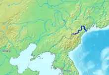
The Tumen River, also known as the Tuman River or Duman River (Korean pronunciation: [tumanɡaŋ]),[lower-alpha 1] is a 521-kilometre (324 mi) long river that serves as part of the boundary between China, North Korea and Russia, rising on the slopes of Mount Paektu and flowing into the Sea of Japan. The river has a drainage basin of 33,800 km2 (13,050 sq mi).[2]
| Tumen River Duman River (두만강; 豆滿江) or Tuman River | |
|---|---|
 | |
 Location of the Tumen River | |
| Etymology | Mongolian, "ten thousand" & Old Korean "ten thousand (드먼 (Tŭmŏn))" |
| Native name | 图们江 (Chinese) |
| Location | |
| Country | North Korea (DPRK), China (PRC), Russia |
| Province (DPRK) | North Hamgyong, Ryanggang |
| Province (PRC) | Jilin |
| Federal subject (Russia) | Primorsky Krai |
| Physical characteristics | |
| Source | Paektu Mountain |
| Mouth | Sea of Japan (East Sea) |
• location | Sea of Japan (East Sea), Russia, North Korea |
• coordinates | 42°17′34″N 130°41′56″E |
• elevation | 0 m (0 ft) |
| Length | 521 km (324 mi) |
| Basin size | 33,800 km2 (13,100 sq mi) |
| Tumen River | |||||||||
|---|---|---|---|---|---|---|---|---|---|
| Chinese name | |||||||||
| Traditional Chinese | 圖們江 | ||||||||
| Simplified Chinese | 图们江 | ||||||||
| |||||||||
| Korean name | |||||||||
| Chosŏn'gŭl | 두만강 | ||||||||
| Hancha | 豆滿江 | ||||||||
| |||||||||
| Mongolian name | |||||||||
| Mongolian Cyrillic | Түмэн гол | ||||||||
| |||||||||
| Manchu name | |||||||||
| Manchu script | ᡨᡠᠮᡝᠨ ᡠᠯᠠ | ||||||||
| Romanization | Tumen ula | ||||||||
| Russian name | |||||||||
| Russian | Туманная река | ||||||||
| Romanization | 'Tumannaya Reka' | ||||||||
The river flows in northeast Asia, on the border between China and North Korea in its upper reaches, and between North Korea and Russia in its last 17 kilometers (11 mi) before entering the Sea of Japan. The river forms much of the southern border of Jilin Province in Northeast China and the northern borders of North Korea's North Hamgyong and Ryanggang provinces. Baekdu Mountain on the Chinese-North Korean border is the source of the river,[3] as well as of the Amnok River, also called the Yalu River (which forms the western portion of the border of North Korea and China).
The name of the river comes from the Mongolian word tümen, meaning "ten thousand" or a myriad. This river is badly polluted by the nearby factories of North Korea and China; however, it still remains a major tourist attraction in the area. In Tumen, Jilin, a riverfront promenade has restaurants where patrons can gaze across the river into North Korea.[3] The Russian name of the river is Tumannaya, literally meaning foggy.
In 1938 the Japanese built the Tumen River Bridge, where the Quan River meets the Tumen River, between the villages of Wonjong (Hunchun) and Quanhe. Important cities and towns on the river are Hoeryong and Onsong in North Korea, Tumen and Nanping (南坪镇, in the county-level city of Helong) in China's Jilin province.
In 1995, the People's Republic of China, Mongolia, Russia, North Korea and South Korea signed three agreements to create the Tumen River Economic Development Area.[4][5][6][7]
Noktundo
Noktundo, a former island (now effectively a peninsula) at the mouth of the Tumen, has been a boundary contention between Russia and North Korea.[8] The Qing Dynasty ceded the island to Russia as part of the Primorsky Maritimes (East Tartary) in the 1860 Treaty of Peking.[8] In 1990, the former Soviet Union and North Korea signed a border treaty which made the border run through the center of the river, leaving territory of the former island on Russian side. South Korea refuses to acknowledge the treaty and demanded that Russia return the territory to Korea.[9]
Illegal crossings
The Tumen has been crossed for years by North Korean refugees defecting across the Chinese border. Most refugees from North Korea during the 1990s famine crossed over the Tumen River, and most recent refugees have also used it, as it is far easier than crossing the Amnok.[10]
The river is considered the preferred way to cross into China because, unlike the swift, deep and broad Amnok River which runs along most of the border between the two countries, the Tumen is shallow and narrow.[3] In some areas it can be crossed on foot, or by short swims.[3] It also freezes in winter allowing dry crossings.[10][11]
Defectors who wish to cross the Tumen often ignore its pollutants and dangerous border patrol, and spend weeks if not months or years waiting for the perfect opportunity to cross. "Long, desolate stretches of the Chinese-North Korean border are not patrolled at all", according to a New York Times article.[3]
Refugees rarely cross the Tumen into Russia. This is because Russia's short stretch of the river is far better patrolled than China's stretch.[3] In addition, the rewards for doing so aren't as high since the ethnic Korean community in Russia is far smaller to receive sufficient support from, as opposed to China, which has a larger Korean population.
The Tumen is also crossed illegally by soldiers and others seeking food and money. Some Chinese villagers have left the border area because of the attacks.[10]
The history of conflict in the area (examples include incidents during the Battle of Lake Khasan) was alluded to in singer Kim Jeong-gu's song 'Tearful Tumen River (눈물 젖은 두만강)', which became an ode to families separated by such tragedies and by defections during the Korean War.[12] The humanitarian crisis along the Tumen River was dramatized in the 2010 dramatic feature-length film. , Dooman River.[13]
 Bridge of Tumen River, built in 1941
 Bridge of Tumen River, shot in 2018
 North Korea is on the other side of the Tumen River
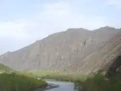
 The Tumen River, at the border between North Korea and China. Picture taken from the Chinese side of the Tumen River at Tumen City; the city of Namyang, North Korea is on the other side of the river
Notes
- Tumen River is a stream in China and has an elevation of 5 metres. Tumen River is close to Mys Sesura.In the 19th century, the river was also known to the West as the Mi Kiang.[1]
References
Citations
- EB (1878), p. 390.
- "DRAINAGE BASINS OF THE SEA OF OKHOTSK AND SEA OF JAPAN" (PDF). www.unece.org.
- Onishi, Norimitsu (22 October 2006). "Tension, Desperation: The China-North Korean Border". The New York Times. Much of the information comes from the captions to the large illustrated map published with the newspaper article and available online with it.
- "Accord on Tumen River Area Development to Be Signed". Archived from the original on 2019-12-15. Retrieved 2010-01-23. Cite journal requires
|journal=(help)(sourced from HighBeam Research) - "Tumen River Area Development Program". Network of East Asian Think-tanks (NEAT). 2009. Archived from the original on 15 January 2015.
- Kim, Myung-sung (14 January 2015). 최고 싱크탱크(think tank)도 "두만강 지역 개발하자" [From top think tank: "Let's develop the Tumen River area"]. Chosun News (in Korean). Archived from the original on 15 January 2015.
- "JPRI Working Paper No. 53". www.jpri.org.
- Головнин, В. И. (2008). "Прошлое как оружие (The past as a weapon)". Россия в глобальной политике (in Russian). 6 (35). Archived from the original on 6 December 2010.
- "The problem of the Noktundo island in the media in South Korea (Проблема острова Ноктундо в средствах массовой информации Южной Кореи)" (in Russian). ru.apircenter.org. Archived from the original on 10 September 2013. Retrieved 2015-06-30.
- Zhai, Keith & Kim, Sam (14 January 2015). "North Koreans Walk Across Frozen River to Kill Chinese for Food". Bloomberg News. Archived from the original on 15 January 2015.
- Moon, Sunghui. "North Korea Tightens Security Before Major Military Parade". Translated by Jun, Leejin; Gerin, Roseanne. Radio Free Asia. Archived from the original on January 25, 2018.
[...] adding that winter is the optimal time of year for North Koreans who wish to defect to cross the frozen Tumen River that separates the country from China, if security is not too heavy.
- Kim, Seon-hee [a.k.a. Sonya] (24 March 2018). "VOD ~ 디지털 KBS" (in Korean). @ 15m 19s mark in video: KBS.
[Translation] I heard that the song consoled many of those who lost their families, or had to leave their hometowns under Japanese occupation and during the Korean war. It made me realize the power of music once again
CS1 maint: location (link) - Bardot, Nicolas (2010). "La Rivière Tumen". Film de Culte (in French). Retrieved 15 January 2015.
Sources
- , 'Encyclopædia Britannica, 9th ed., Vol. VI, New York: Charles Scribner's Sons, 1878, pp. 390–394.
- Nianshen Song. 2018. Making Borders in Modern East Asia: The Tumen River Demarcation, 1881–1919. Cambridge University Press.
External links
| Wikimedia Commons has media related to Tumen River. |
