Kingston SE
Kingston SE (formerly Kingston) is a town in the Australian state of South Australia located in the state's south-east coastline on the shores of Lacepede Bay. It is located about 240 kilometres (150 miles) southeast of the state capital of Adelaide and 138 kilometres (86 miles) north-west of the centre of the city of Mount Gambier. At the 2016 census, Kingston SE had a population of 1,648.[2]
| Kingston SE South Australia | |||||||||||||||
|---|---|---|---|---|---|---|---|---|---|---|---|---|---|---|---|
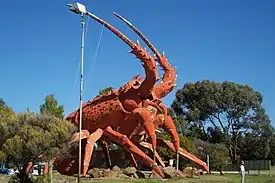 Lobster sculpture located at the entrance to the town | |||||||||||||||
 Kingston SE | |||||||||||||||
| Coordinates | 36°49′S 139°51′E[1] | ||||||||||||||
| Population | 1,648 (2016 census)[2] | ||||||||||||||
| Established | 1861 (town) 3 December 1998 (locality)[1][3] | ||||||||||||||
| Postcode(s) | 5275[4] | ||||||||||||||
| Time zone | ACST (UTC+9:30) | ||||||||||||||
| • Summer (DST) | ACDT (UTC+10:30) | ||||||||||||||
| Location |
| ||||||||||||||
| LGA(s) | Kingston District Council[1] | ||||||||||||||
| State electorate(s) | MacKillop[5] | ||||||||||||||
| Federal Division(s) | Barker[6] | ||||||||||||||
| |||||||||||||||
| |||||||||||||||
| Footnotes | Locations[4] Adjoining Localities[1] | ||||||||||||||
History
Kingston, South Australia was established in the 1800s by Archibald, his brother James Cooke and James' wife Mrs. Mary Macpherson Cooke. Much later a Sir George Strickland Kingston, a South Australian politician, surveyor and architect was chosen, for the co-incidence of his name, to open the Kingston Post Office on 9 February 1869.[7] The extension on its name is to distinguish Kingston in the South East (of South Australia) from another 'Kingston' in the state which is now officially named "Kingston On Murray". The extension was added in July 1940.[8] The present-day town of Kingston SE includes the original Kingston, as well as the towns of Port Caroline and Maria Creek.[9]
The town was connected to Naracoorte by a 3 ft 6 in (1,067 mm) railway known as the Kingston-Naracoorte railway in 1876, providing a port for the grain and wool grown away from the coast. The rails were converted to broad gauge 5 ft 3 in (1,600 mm) with a new station built on the edge of town in 1959. The railway closed on 28 November 1987 then was dismantled on 15 September 1991.[10]
Media
The region was formerly serviced by two newspapers: the Kingston Weekly, the newspaper of The Kingston Traders' Association, was issued between 22 March 1946 and 30 March 1951. Later, the South-East Kingston Leader was started in Kingston, and was published from 1962 until 21 November 2001 when it was renamed Coastal Leader, and is now a member of Fairfax Media Limited.
Today
The main industries are fishing, wine-making, sheep and cattle farming and recreation, the district having a large influx of tourists during holiday periods throughout the year.
The northern entrance to the town is dominated by the Big Lobster, named "Larry" by people in Kingston.[11]
The town has an Australian rules football team competing in the Kowree-Naracoorte-Tatiara Football League.[12]
Climate
Kingston has a warm-summer Mediterranean climate (Csb).
| Climate data for Cape Jaffa | |||||||||||||
|---|---|---|---|---|---|---|---|---|---|---|---|---|---|
| Month | Jan | Feb | Mar | Apr | May | Jun | Jul | Aug | Sep | Oct | Nov | Dec | Year |
| Record high °C (°F) | 41.6 (106.9) |
40.8 (105.4) |
37.3 (99.1) |
33.1 (91.6) |
27.2 (81.0) |
22.4 (72.3) |
19.5 (67.1) |
23.3 (73.9) |
27.5 (81.5) |
33.1 (91.6) |
37.2 (99.0) |
40.3 (104.5) |
41.6 (106.9) |
| Average high °C (°F) | 24.6 (76.3) |
24.6 (76.3) |
22.7 (72.9) |
19.9 (67.8) |
17.0 (62.6) |
14.7 (58.5) |
14.0 (57.2) |
14.6 (58.3) |
16.1 (61.0) |
18.5 (65.3) |
21.4 (70.5) |
22.8 (73.0) |
19.2 (66.6) |
| Average low °C (°F) | 13.6 (56.5) |
13.6 (56.5) |
12.4 (54.3) |
10.6 (51.1) |
9.2 (48.6) |
8.0 (46.4) |
7.5 (45.5) |
7.8 (46.0) |
8.5 (47.3) |
9.1 (48.4) |
10.8 (51.4) |
12.3 (54.1) |
10.3 (50.5) |
| Record low °C (°F) | 6.5 (43.7) |
6.3 (43.3) |
5.2 (41.4) |
1.3 (34.3) |
0.0 (32.0) |
−0.7 (30.7) |
0.1 (32.2) |
0.2 (32.4) |
1.0 (33.8) |
2.6 (36.7) |
3.4 (38.1) |
4.7 (40.5) |
−0.7 (30.7) |
| Average rainfall mm (inches) | 16.6 (0.65) |
17.6 (0.69) |
22.6 (0.89) |
33.5 (1.32) |
50.6 (1.99) |
69.3 (2.73) |
81.0 (3.19) |
71.5 (2.81) |
47.9 (1.89) |
33.8 (1.33) |
26.7 (1.05) |
24.5 (0.96) |
495.6 (19.5) |
| Average rainy days (≥ 0.2mm) | 5.6 | 4.9 | 8.5 | 12.5 | 16.9 | 18.6 | 19.6 | 21.4 | 16.8 | 12.8 | 8.7 | 8.5 | 154.8 |
| Source: Bureau of Meteorology[13] | |||||||||||||
See also
References
- "Search result for "Kingston SE(Locality Bounded)" (Record no SASA0036846) with the following layers selected – "Suburbs and Localities", "Place names (gazetteer)" and "Development Plan Layers"". Property Location Browser. Government of South Australia. Archived from the original on 12 October 2016. Retrieved 31 August 2016.
- Australian Bureau of Statistics (27 June 2017). "Kingston SE (Urban Centre)". 2016 Census QuickStats. Retrieved 1 January 2020.

- "GEOGRAPHICAL NAMES ACT 1991 Notice to Assign Boundaries and Names to Places (in the District Council of Lacepede)" (PDF). The South Australian Government Gazette. Government of South Australia: 1711. 3 December 1998. Retrieved 4 December 2018.
- "Postcode for Kingston SE, South Australia". postcodes-australia.com. Retrieved 31 August 2016.
- "District of MacKillop Background Profile". Electoral Commission SA. Retrieved 29 March 2016.
- "Federal electoral division of Barker" (PDF). Australian Electoral Commission. Retrieved 28 March 2016.
- Premier Postal History, Post Office List, retrieved 11 April 2008
- "NEW TOWN NAMES APPROVED". The Chronicle. LXXXIII (4, 728). South Australia. 1 August 1940. p. 13. Retrieved 31 August 2016 – via National Library of Australia.
- "Kingston SE". Placenames of South Australia. Retrieved 23 December 2016 – via State Library of South Australia.
- Diesel Days on the Kingston S.E. Goods Milne, Rod Australian Railway Historical Society Bulletin, October, 1997 pp356-364
- http://www.abc.net.au/backyard/stories/s1020963.htm Retrieved 2008.09.30
- Full Points Footy, Kowree-Naracoorte-Tatiara, archived from the original on 13 May 2007, retrieved 25 July 2008
- "Cape Jaffa (The Limestone)". Climate statistics for Australian locations. Bureau of Meteorology. April 2014. Retrieved 3 April 2014.
