Kotalpur, Hooghly
Kotalpur is a village and a gram panchayat in the Jangipara CD block in the Srirampore subdivision of Hooghly district in the Indian state of West Bengal.
Kotalpur | |
|---|---|
Village | |
 Kotalpur Location in West Bengal, India  Kotalpur Kotalpur (India) | |
| Coordinates: 22.7017°N 88.0872°E | |
| Country | |
| State | West Bengal |
| District | Hooghly |
| Population (2011) | |
| • Total | 6,948 |
| Languages | |
| • Official | Bengali, English |
| Time zone | UTC+5:30 (IST) |
| PIN | 712404 |
| Telephone/STD code | 03212 |
| Lok Sabha constituency | Sreerampur |
| Vidhan Sabha constituency | Jangipara |
| Website | hooghly |
Geography
| Cities and towns in Chanditala I, Chanditala II and Jangipara CD Blocks in Srirampore subdivision in Hooghly district M: municipal city/ town, CT: census town, R: rural/ urban centre, Owing to space constraints in the small map, the actual locations in a larger map may vary slightly |
Location
Kotalpur is located at 22.7017°N 88.0872°E
Urbanisation
Srirampore subdivision is the most urbanized of the subdivisions in Hooghly district. 73.13% of the population in the subdivision is urban and 26.88% is rural. The subdivision has 6 municipalities and 34 census towns. The municipalities are: Uttarpara Kotrung Municipality, Konnagar Municipality, Serampore Municipality, Baidyabati Municipality, Rishra Municipality and Dankuni Municipality. Amongst the CD Blocks in the subdivision, Uttarapara Serampore (census towns shown in a separate map) had 76% urban population, Chanditala I 42%, Chanditala II 69% and Jangipara 7% (census towns shown in the map above).[1][2] All places marked in the map are linked in the larger full screen map.
Demographics
According to the 2011 Census of India, Kotalpur had a total population of 6,948 of which 3,484 (50%) were males and 3,464 (50%) were females. Population in the age range 0–6 years was 915. The total number of literate persons in Kotalpur was 4,718 (78.20% of the population over 6 years).[3]
Culture
David J. McCutchion mentions the Rajrajeswara temple as an at chala having terracotta panoramic battle scenes above the archway and smaller figures around the façade.[4]
The Rajrajeswara temple (at Sr No S-WB-62) at Kotalpur is included in the List of State Protected Monuments in West Bengal by the Archaeological Survey of India.[5]
Kotalpur picture gallery
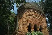 Rajrajeswara temple, photographed in 2011.
References
- "District Statistical Handbook 2014 Hooghly". Table 2.2, 2.4(a). Department of Statistics and Programme Implementation, Government of West Bengal. Archived from the original on 21 January 2019. Retrieved 3 October 2018.
- "C.D. Block Wise Primary Census Abstract Data(PCA)". 2011 census: West Bengal – District-wise CD Blocks. Registrar General and Census Commissioner, India. Retrieved 3 October 2018.
- "2011 Census – Primary Census Abstract Data Tables". West Bengal – District-wise. Registrar General and Census Commissioner, India. Retrieved 25 September 2020.
- McCutchion, David J., Late Mediaeval Temples of Bengal, first published 1972, reprinted 2017, pages 35. The Asiatic Society, Kolkata, ISBN 978-93-81574-65-2
- "Protected Monuments in West Bengal". Archaeological Survey of India. Retrieved 27 September 2020.
External links
| Wikimedia Commons has media related to Kotalpur, Hooghly. |