Singjor
Singjor is a village in Chanditala I community development block of Srirampore subdivision in Hooghly district in the Indian state of West Bengal.[1]
Singjor | |
|---|---|
Village | |
 Singjor Location in West Bengal, India  Singjor Singjor (India) | |
| Coordinates: 22.696374°N 88.18553°E | |
| Country | |
| State | West Bengal |
| District | Hooghly |
| Government | |
| • Type | Panchayati raj (India) |
| • Body | Gram panchayat |
| Population (2011) | |
| • Total | 1,589 |
| Languages | |
| • Official | Bengali, English |
| Time zone | UTC+5:30 (IST) |
| PIN | 712701 |
| ISO 3166 code | IN-WB |
| Vehicle registration | WB |
| Lok Sabha constituency | Serampore |
| Vidhan Sabha constituency | Chanditala |
| Website | wb |
Geography
Singjor is located at 22.696374°N 88.18553°E.
Gram panchayat
Villages and census towns in Bhagabatipur gram panchayat are: Bhadua, Bhagabatipur, Jalamadul, Kanaidanga, Metekhal and Singjor.[2]
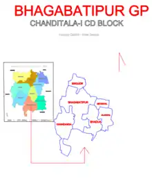
Map of BHAGABATIPUR GP
Demographics
As per 2011 Census of India, Singjor had a total population of 1,589 of which 848 (53%) were males and 741 (47%) were females. Population below 6 years was 208. The total number of literates in Singhjor was 1,219 (88.27% of the population over 6 years).[3]
References
- "banglarbhumi.gov.in". WEST BENGAL ->HUGLI(হুগলী) ->CHANDITALA-I (চণ্ডীতলা-১) Mouza Information. Archived from the original on 22 December 2016.
- "Kanaidanga". Indian Village Directory. Retrieved 12 October 2018.
- "C.D. Block Wise Primary Census Abstract Data(PCA)". 2011 census: West Bengal – District-wise CD Blocks. Registrar General and Census Commissioner, India. Retrieved 7 October 2018.
Cities, towns and locations in Hooghly district | |||||||||
|---|---|---|---|---|---|---|---|---|---|
| Cities, municipalities and census towns |
| ||||||||
| Locations other than cities and towns |
| ||||||||
| Neighbourhoods | |||||||||
| Related topics |
| ||||||||
This article is issued from Wikipedia. The text is licensed under Creative Commons - Attribution - Sharealike. Additional terms may apply for the media files.
