Pandua, Hooghly
Pandua is a census town in the Pandua CD block in the Chinsurah subdivision of the Hooghly district in the Indian state of West Bengal.[1]
Pandua | |
|---|---|
Census Town | |
 Pandua Location in West Bengal, India  Pandua Pandua (India) | |
| Coordinates: 23.08°N 88.28°E | |
| Country | |
| State | West Bengal |
| District | Hooghly |
| Elevation | 19 m (62 ft) |
| Population (2011) | |
| • Total | 30,700 |
| Languages | |
| • Official | Bengali, English |
| Time zone | UTC+5:30 (IST) |
| PIN | 712149 |
| Vehicle registration | WB |
| Lok Sabha constituency | Hooghly |
| Vidhan Sabha constituency | Pandua |
Geography
| Cities and towns in the Chinsurah subdivision (except Polba Dadpur and Dhaniakhali CD Blocks) in Hooghly district M: municipal city/ town, CT: census town, R: rural/ urban centre, Owing to space constraints in the small map, the actual locations in a larger map may vary slightly |
Location
Pandua is located at 23.08°N 88.28°E.[2] It has an average elevation of 19 metres (62 feet).
Pandua, Purusattompur and Namajgram form a cluster of census towns.[2]
Pandua CD block is a flat alluvial plain, known as the Hooghly-Damodar Plain, that forms part of the Gangetic Delta.[3]
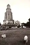
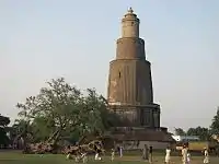
The place is best known for its minar[4] and the ruins of Pandu Raja's Palace where all important state ceremonies were held.[5] The 13th century minar soars to a height of 125 feet.[6]
History
According to Binoy Ghosh, the tall Pandua minar can be seen by those travelling in trains or along the Grand Trunk Road. It is locally said that Shah Sufiuddin defeated the Hindu king of the Pandua and Mahanad area and built this victory pillar. Mahiuddin Ostagar of Santipur composed a poem, Panduar Kechha, in which he describes how Muslim domination of the area was achieved. There was a king named Pandu in Pandua. Inside his palace there was a well blessed by the gods. When the body of a dead person was immersed in its waters, the person regained life. During the reign of king Pandu, mostly Hindus lived in Pandua, and there were a few Muslims. One day a Muslim peasant killed a cow on his son’s birthday. This enraged the Hindus and they killed the son. The Muslim peasant complained to king Pandu but he did not take any action. The peasant carried the dead body of his son to the Badshah at Delhi, Feroze Shah. After listening to the complaint, he sent his nephew, Shah Sufi, at the head of an army, to Pandua. He waged war but initially he was unsuccessful, because of the life-giving properties of the divine well. Frustrated Shah Sufi was almost on the verge of returning to Delhi, when a cowherd boy revealed the secret of the divine well to Shah Sufi. The boy, dressed as a yogi, entered the palace and threw some beef into the well, thereby destroying its divine properties. The Muslim forces captured Pandua, and Shah Sufi remained back in Pandua. He built a large mosque there.[7]
Historically, there is no evidence of the existence of king Pandu, but there were many minor Hindu kings in the Saptagram-Pandua area. Within a century of Bakhtiyar Khilji’s conquest, the Muslim thrust into the southern parts of the Rarh region, that included present-day Hooghy district, started from the end of the 13th century to the 14th century. It was during the rule of the Balban sultans in Delhi (1286-1328) that the efforts were made to establish Islam, not only by capturing the thrones and political power, but also establish Islam socially. Their modus operandi was “to enter the territory of the Hindu rajas as squatters on some prtext or other. Then they would bring down the regular army of the Muslim State upon these infidel kings to punish them for infringing the rights of Mussalmans.”[8][7]
According to the available records, Zafar Khan had come to the Tribeni area towards the end of the 13th century and Shah Sufiuddin had come to the Pandua area towards the beginning of the 14th century. During the period that followed Muslim Ghazis built many mosques and tombs on the ruins of Hindu temples. There is tell-tale evidence of the historical role of Muslim Ghazi-Pirs in the Pandua-Mahanad-Tribeni area.[7]
The Shrikkhala Devi Shrine as a Shakti Peeth
The mythology of Daksha yaga and Sati's self immolation had immense significance in shaping the ancient Sanskrit literature and even had impact on the culture of India. It led to the development of the concept of Shakti Peethas and there by strengthening Shaktism. Enormous mythological stories in puranas took the Daksha yaga as the reason for its origin. It is an important incident in Shaivism resulting in the emergence of Shree Parvati in the place of Sati Devi and making Shiva a grihastashrami (house holder) leading to the origin of Ganapathy and Subrahmanya.[9]
Shakti Peethas are shrines or divine places of the Mother Goddess. These are places that are believes to have enshrined with the presence of Shakti due to the falling of body parts of the corpse of Sati Devi, when Lord Shiva carried it and wandered throughout Aryavartha in sorrow. There are 51 Shakti Peeth linking to the 51 alphabets in Sanskrit.
Note: The lists of shrines provided in the linked articles does not mention any shaktipeeth in the Pandua area and no references are there to show the existence of a shakti peeth at/around Pandua.
Demographics
According to the 2011 Census of India, Pandua had a total population of 30,700 of which 15,597 (51%) were males and 15,103 (49%) were females. Population in the age range 0–6 years was 2,986. The total number of literate persons in Pandua was 22,604 (81.56% of the population over 6 years).[10]
As of 2001 India census, Pandua had a population of 27,126. Males constitute 51% of the population and females 49%. Pandua has an average literacy rate of 67%, higher than the national average of 59.5%: male literacy is 72%, and female literacy is 62%. In Pandua, 12% of the population is under 6 years of age.[11]
Civic administration
CD block HQ
The headquarters of Pandua CD block are located at Pandua.[14]
Economy
This is a rich agricultural area with several cold storages.[15]
S.R.Industry, manufacturer of construction and agricultural machinery was established at Pandua in 1996.[16]
Transport
State Highway 13/ GT Road passes through Pandua.[17][18]
Pundooah railway station situated on Howrah-Bardhaman main line.
Healthcare
Pandua has a rural hospital (with 30 beds).[19]
Visitor attractions
- Bari Masjid: The meaning of the bari is "the big mosque which shows the incredible architecture styled with Bricks". It was built by Shah Sufiuddin in 14th century.
- Pandua Minar: It was built by Shah Sufiuddin in 1340 AD and it is symbol of victory
Pandua picture gallery


Pandua mosque
Monument of National Importance
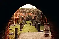 The mosque
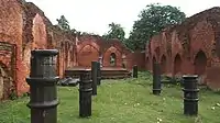 Bari masjid
.jpg.webp) The mosque
The mosque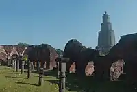 The minar in the distance
The other Pandua
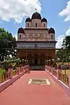 Mahanad Kali temple
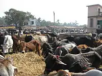 Cattle market
References
- District-wise list of statutory towns Archived 2007-09-30 at the Wayback Machine
- "Census of India 2011, West Bengal: District Census Handbook, Hooghly" (PDF). Map of Pandua CD Block, page 385. Directorate of Census Operations, West Bengal. Retrieved 25 September 2018.
- "District Census Handbook: Hugli, Series-20, Part XIIA" (PDF). Physiography, Page 17. Directorate of Census Operations, West Bengal, 2011. Retrieved 28 September 2018.
- Husain, ABM (2012). "Chhota Pandua Minar". In Islam, Sirajul; Jamal, Ahmed A. (eds.). Banglapedia: National Encyclopedia of Bangladesh (Second ed.). Asiatic Society of Bangladesh.
- Das, Dipakranjan (2012). "Bari Mosque". In Islam, Sirajul; Jamal, Ahmed A. (eds.). Banglapedia: National Encyclopedia of Bangladesh (Second ed.). Asiatic Society of Bangladesh.
- Minars and Minarettes of India
- Ghosh, Binoy, Paschim Banger Sanskriti, (in Bengali), part II, 1976 edition, pages 312-316 , Prakash Bhaban, Kolkata.
- The author has quoted from History of Bengal, Dacca University, Vol II, p. 69
- "Kottiyoor Devaswam Temple Administration Portal". kottiyoordevaswom.com/. Kottiyoor Devaswam. Retrieved 20 July 2013.
- "C.D. Block Wise Primary Census Abstract Data(PCA)". 2011 census: West Bengal – District-wise CD Blocks. Registrar General and Census Commissioner, India. Retrieved 10 June 2016.
- "Census of India 2001: Data from the 2001 Census, including cities, villages and towns (Provisional)". Census Commission of India. Archived from the original on 16 June 2004. Retrieved 10 June 2016.
- "District Statistical Handbook 2014 Hooghly". Tables 2.1, 2.2. Department of Statistics and Programme Implementation, Government of West Bengal. Archived from the original on 21 January 2019. Retrieved 3 October 2018.
- "Hooghly District Police". West Bengal Police. Archived from the original on 5 July 2017. Retrieved 20 June 2017.
- "District Census Handbook: Hugli, Series-20, Part XIIA" (PDF). Map of Hooghly district with CD Block HQs and Police Stations (on the fifth page). Directorate of Census Operations, West Bengal, 2011. Retrieved 20 June 2017.
- "List of functioning Cold Storage of West Bengal District wise as on 18.01.07". West Bengal State Marketing Board. Archived from the original on 22 January 2009. Retrieved 28 January 2009.
- "S.R.Industry". indiamart.com. Retrieved 14 July 2017.
- "Road - Highway". Public Works Department, Government of West Bengal. Retrieved 24 February 2017.
- Google maps
- "Health & Family Welfare Department". Health Statistics. Government of West Bengal. Retrieved 15 July 2017.
External links
| Wikimedia Commons has media related to Pandua (Hooghly). |
- Pandua Image gallery
- Travel article on Pandua by Rangan Datta
- Rangan Datta's Home Page
- Shrinkhala Shaktipith at Pandua
