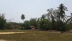
Krishnarampur
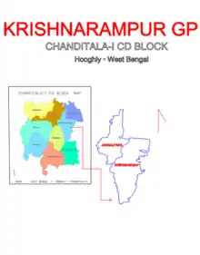
Krishnarampur is a village and a gram panchayat in Chanditala I community development block in Srirampore subdivision of Hooghly district in the state of West Bengal, India. It is under Chanditala police station.[1]
Krishnarampur | |
|---|---|
Village | |
 | |
 Krishnarampur Location in West Bengal, India  Krishnarampur Krishnarampur (India) | |
| Coordinates: 22.721831°N 88.216765°E | |
| Country india | |
| State | West Bengal |
| District | Hooghly |
| Government | |
| • Type | Panchayati raj (India) |
| • Body | Gram panchayat |
| Population (2011) | |
| • Total | 10,044 |
| Languages | |
| • Official | Bengali, English |
| Time zone | UTC+5:30 (IST) |
| ISO 3166 code | IN-WB |
| Vehicle registration | WB |
| Lok Sabha constituency | Serampore |
| Vidhan Sabha constituency | Chanditala |
| Website | wb |
Before Krishnarampur, whose name was "Kristrampur". It is believed that the name was changed after 1947. At that time rice was very popular here. There were many big rice warehouses here. From all the unique areas, bullock carts used to come here to buy and sell paddy rice, then from Krishnarampur to Howrah rice was traded through Martin's Light Railways (MLR).
Between 1907-1908, Martin's Light Railways (MLR) was fully operational here from Howrah to Shiakhala.
Until 1947 it was run by the British government and Martin.co. These have been run privately since the country became independent in 1947. This railway line was finally closed in 1971.
Between 1907-1908, Martin's Light Railways (MLR) was fully operational here from Howrah to Shiakhala.
Geography
Krishnarampur is located at 22.721831°N 88.216765°E.
Gram panchayat
Villages and census towns in Krishnarampur gram panchayat are: Krishnarampur and Jangalpara.[2]
Demographics
As per 2011 Census of India, Krishnarampur had a total population of 10,044 of which 5,024 (50%) were males and 5,020 (50%) were females. Population below 6 years was 912. The total number of literates in Krishnarampur was 7,734 (84.69% of the population over 6 years).[3]
Transport
- Railway
Baruipara railway station its nearest railway station on Howrah-Bardhaman chord, which is a part of the Kolkata Suburban Railway system.
- Road
The main road is SH 15 (Ahilyabai Holkar Road). It is the main artery of the village and it is connected to NH 19 (old numbering NH 2)/Durgapur Expressway.
- Bus
Private Bus
- 26 Bonhooghly - Champadanga
- 26A Serampore - Aushbati
- 26C Bonhooghly - Jagatballavpur
Bus Routes without Numbers
- Howrah Station - Bandar (Dhanyaghori)
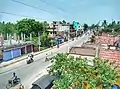
Krishnarampur gallery


References
- "banglarbhumi.gov.in". WEST BENGAL ->HUGLI(হুগলী) ->CHANDITALA-I (চণ্ডীতলা-১) Mouza Information. Government of West Bengal. Archived from the original on 22 December 2016. Retrieved 6 October 2018.
- "Krishnarampur". Indian Village Directory. Retrieved 12 October 2018.
- "C.D. Block Wise Primary Census Abstract Data(PCA)". 2011 census: West Bengal – District-wise CD Blocks. Registrar General and Census Commissioner, India. Retrieved 7 October 2018.
Cities, towns and locations in Hooghly district | |||||||||
|---|---|---|---|---|---|---|---|---|---|
| Cities, municipalities and census towns |
| ||||||||
| Locations other than cities and towns |
| ||||||||
| Neighbourhoods | |||||||||
| Related topics |
| ||||||||
